drought

Near Record Warmth and Quite Dry…until the 30th: September 2015 Recap

October 4, 2015 - 3:30pm -- Dave Robinson

Wildfire photo

The ninth month of 2015 served as a bookend of sorts to an extended warm season. The average statewide temperature of 70.7° was 4.5° above the 1981–2010 normal and ranks as the 3rd warmest on record (since 1895). This ranking is the same as that achieved in May, with the intervening months all above average, though not nearly as much so as these shoulder months. Five of the ten warmest Septembers have occurred since 2002. A look back at the past five months finds that this most recent May through September interval was the third warmest on record. Even more notable than the recent run of warm Septembers, eight of the top ten warm seasons occurred within the last 18 years and four within the last six years.

What had been a rather dry month with drought concerns ended on a damp note on the 30th with a wet episode that extended into early October. Through the 29th, the month ranked as the 14th driest. However, an approximate statewide-average rainfall of 1.50” on the 30th brought the monthly average to 3.44” (-0.63”) and with it the rank of 63rd driest.

New Jersey Smart Lawn Watering Initiative: Conserving Water Starts With You!

September 15, 2015 - 4:49pm -- Jessica Raff

Grass photo

About 70% of the fresh water used around the world is devoted to irrigation, and a similar figure holds true with respect to New Jersey’s water use. Much of this in New Jersey is put towards lawn watering. It is apparent to anyone paying attention to the frequency and timing of when lawns are watered that, just as research suggests, many New Jersey homeowners are over-irrigating their lawns. This wastes precious water that could be conserved wisely by employing more efficient irrigation methods. This article outlines a simple way that you can participate in our New Jersey Smart Lawn Watering Initiative without investing in new sprinkler equipment or devoting large amounts of time to lawn management. By following the instructions discussed below, you can save water and money, while keeping your lawn green and beautiful.

Consistently Warm and a Mixed Distribution of Precipitation: August & Summer 2015 Recaps

September 2, 2015 - 9:58pm -- Dave Robinson

Dry Reservior

This month had quite a variety of weather conditions around the state. This resulted in some areas experiencing flash flooding and others encroaching drought conditions. Damage resulted from the flooding and one storm even produced a nocturnal “heat burst.” Some minor brush fires and declining river, ground water, and reservoir levels accompanied subnormal rain totals. The dry conditions helped produce some wide daily swings from cool nighttime temperatures to consistently warm daytime maximums. Preliminary values show August 2015 to have a statewide average rainfall of 2.18”. This is 2.03” below normal and ranks as the 13th driest since statewide records commenced in 1895 (Table 1). The 74.5° average temperature was 1.1° above the 1981–2010 mean and ranks 21st warmest.

Drought? What Drought?: June 2015 Recap

July 4, 2015 - 7:34pm -- Dave Robinson

Roll Cloud photo

Toward the end of May, the threat of a significant drought loomed over the Garden State, as May proved to be the 3rd driest on record. Crops were in bad shape or not growing at all, and reservoir levels were declining at a faster than seasonal rate. However, New Jersey had yet to reach the point where average and timely rainfall could not remedy the situation. Not only was this prescription filled, it was done in abundance. June rainfall averaged 8.21" across NJ. This was 4.19" above the 1981-2010 normal and ranked 4th wettest since 1895 (Table 1). It joined four other Junes in the past 13 years to rank in the top eight over this 121-year period. As explained in last month's report, the rains that fell during the daytime and evening hours of May 31st factored into the June total, much as the localized afternoon and evening rains on June 30th (discussed below) will count toward the July total.

Third Warmest and Driest as Drought Concerns Arise, and a Pronounced Transition: May and Spring 2015 Recap

June 4, 2015 - 8:52pm -- Dave Robinson

Sea fog photo

May 2015 was a warm and dry month across New Jersey. As the month ended, drought concerns were looming large, though rainfall in the north during the afternoon and evening of the 31st and continuing into the first days of June resulted in at least a temporary braking of the downward slide. Based on data gathered at long-term National Weather Service Cooperative Observing (COOP) stations, May rainfall averaged 1.08" across NJ. This is 2.92" below the 1981-2010 mean and ranks as the 3rd driest May since records commenced in 1895.

As those who have been reading these monthly narratives for some time now know, precipitation that falls at COOP stations after observation time on the last day of the month gets recorded as falling on the first day of the next month. Most COOP stations observe in the morning, thus the heavy showers that fell across north Jersey on the 31st were not factored into this May average, except for a few stations such as Newark Airport (which registered 3.83" on the 31st alone) that observe at midnight. The last time this situation had a notable impact on monthly rainfall was a daytime heavy rain event on April 30, 2014.

Drought Invading New Jersey

May 28, 2015 - 11:14am -- Dave Robinson

30-Day Percent of Normal Precipitation

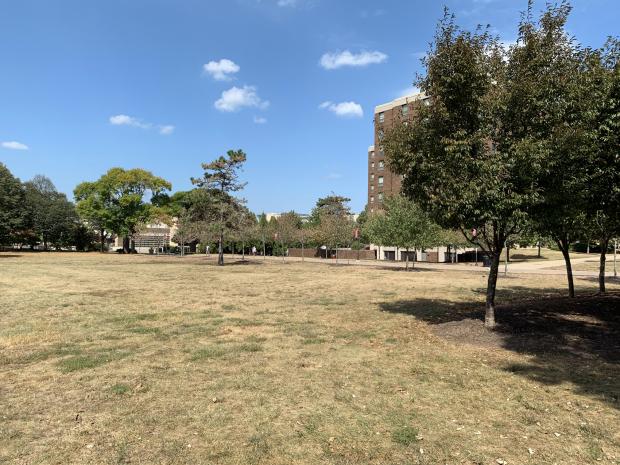
Whether it is a browning lawn, dry garden soil, or pollen that hasn’t washed off your car in weeks, many of us in New Jersey have recognized that the state is in the midst of an extended period of very meager rainfall. Along with the aforementioned impacts, the flow of water in streams and ground water levels as monitored in wells are below, and in some cases, well below seasonal levels. While it is fortunate that surface reservoirs in northern and central NJ are close to seasonal levels (quite full), there is less water than normal flowing into them and early season lawn watering is drawing water out of them at an unseasonable pace.

Advice provided by our office, by those within the National Weather Service and the NJ Department of Environmental Protection, and by others associated with the weekly US Drought Monitor has led to this week’s Monitor map depicting the northern third of NJ in D1 (defined as moderate drought) and the remainder of the state down to around the Atlantic City Expressway in D0 (abnormally dry). D1 can be expected to occur once every 5-10 years during a particular month, while D0 can be found every 3-5 years. While the type of conditions being experienced in parts of NJ right now are drought like, I am hesitant to call the north in “moderate” drought, and would prefer saying “minor” drought. However, this is the definition of the nomenclature decided upon by a national committee, thus within the Monitor map it is “moderate” in the north.

Increasingly Dry in the North: September 2014 Recap

October 6, 2014 - 3:04pm -- Dave Robinson

Dry grass

Combined with below-average precipitation in August, the northern half of New Jersey has become quite dry. Conversely, rainfall has been more common in the south, thus despite a drier-than-average September, the two-month total is slightly above average. Looking first at September, statewide precipitation averaged 2.82". This is 1.25" below the 1981-2010 average and ranks as the 46th driest September since 1895. From Hunterdon, Somerset, and Union counties northward, only 1.49" fell, which is 3.00" below average and ranks as 7th driest. The southern counties averaged 3.47", which is 0.40" below average and ranks as 56th wettest.

Encroaching Drought?: November and Fall 2013 Summary

December 1, 2013 - 12:00am -- Dave Robinson

Dry reservoir photo

The first statewide nor'easter of the season on the 26th-27th provided much needed rainfall and kept the month from becoming one of the driest on record. Storm specifics are found below, confirming that this event accounted for the bulk of the statewide monthly average of 2.83" and at least temporarily staved off worsening drought conditions. This was 0.81" below the 1981-2010 normal and ranked as the 52nd driest of the past 119 years. Temperatures seesawed a fair bit but overall, colder than average conditions prevailed for the second consecutive November. The statewide average of 43.0° was 2.6° below normal and tied with 1906, 1919, 1940 and 1986 as the 36th coolest on record. Rather frequent frontal passages resulted in winds gusting to 40 mph or greater on twelve November days.

Pages

Subscribe to RSS - drought