smoke

Is That All There Is?/Dodging Extremes, With a Few Exceptions: August/Summer 2023 Recaps

September 7, 2023 - 6:45pm -- Dave Robinson

The confluence of the Raritan and Millstone Rivers as seen from the Delaware-Raritan Canal Towpath in Franklin Township (Somerset County) on August 20th. Photo by Dave Robinson.

It is not as if August 2023 was devoid of strong thunderstorms that produced locally heavy rain and three minor tornadoes. There were also some hot and humid days and even a few days with smoke high aloft, a rather persistent feature of this summer’s weather (more on this in earlier June and July recaps and the summer summary later in this report). However, with temperatures a bit below normal and statewide rainfall leaning that way too, it just was not a particularly notable August in the weather/climate department. Mind you, most folks hardly complained of 90° maximum temperatures being rather scarce, there being no soaking tropical system, and, for the most part, fine weather for outdoor activities.

Statewide, the average temperature of 72.9° was 0.7° below the 1991–2020 normal. This ranked as the 48th warmest August of the past 129, but the coolest since 2017. Three of the past four months have been below normal, something not accomplished since January, March, and April 2018. The average high of 82.4° was 1.4° below normal, ranking 60th warmest. The low of 63.4° was 0.1° above normal, raking 31st warmest. The northern climate division averaged 70.7° (-1.2°, 53rd warmest), the southern division 74.2° (-0.4°, 46th warmest), and coastal division 74.5° (-0.2°, 38th warmest).

Precipitation averaged 4.03” across NJ, which is 0.54” below normal and ranks as 61st driest (68th wettest) since 1895. There was a north/south difference in rainfall, with the north averaging 5.02” (+0.46”, 41st wettest/89th driest), the south 3.45” (-1.12”, 49th driest/81st wettest), and coastal NJ 3.14” (-1.46”, 42nd driest/88th wettest).

Sultry: July 2023 Recap

August 7, 2023 - 5:22pm -- Dave Robinson

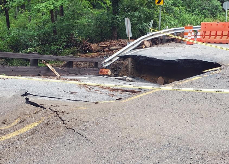
The aftermath of flash flooding in Warren County on July 16th as seen along Brass Castle Creek on Harmony Brass Castle Road by Hartsman Corner Road, Washington Township.

Yet another warmer-than-normal July is in the books. Nine of New Jersey’s 11 hottest Julys dating back to 1895 have occurred since 2010. Unlike last year where the heat was accompanied by the 12th driest July, this year was a wet and humid one, the 22nd wettest on record. The statewide average temperature of 77.2° was 1.8° above the 1991–2020 normal and 3.3° above the 1895–2021 period-of-record mean, ranking 10th warmest on record (tied with 2016). The average high was 87.0°, 1.3° above normal and ranking 18th warmest. The average low was 67.4°, 2.3° above normal and ranking 4th warmest. The northern climate division averaged 75.2° (+1.5°, 12th warmest), the southern division 78.5° (+2.0°, 10th), and the coast 78.3° (+2.1, 8th).

The 6.27” statewide average precipitation was 1.56” above normal to earn the 22nd wettest ranking. The northern division averaged 7.37” (+2.65”, 16th wettest), southern division 5.64” (+0.90”, 30th), and the coast 5.09” (+0.71”, 36th). The largest totals were found in Warren County and adjacent northwest counties, with some totals over a foot. The Pinelands region received the least, with totals of 2.50” to 3.50”.

Strange, Just Plain Strange: June 2023 Recap, Plus First Half of 2023 Review

July 11, 2023 - 9:38pm -- Dave Robinson

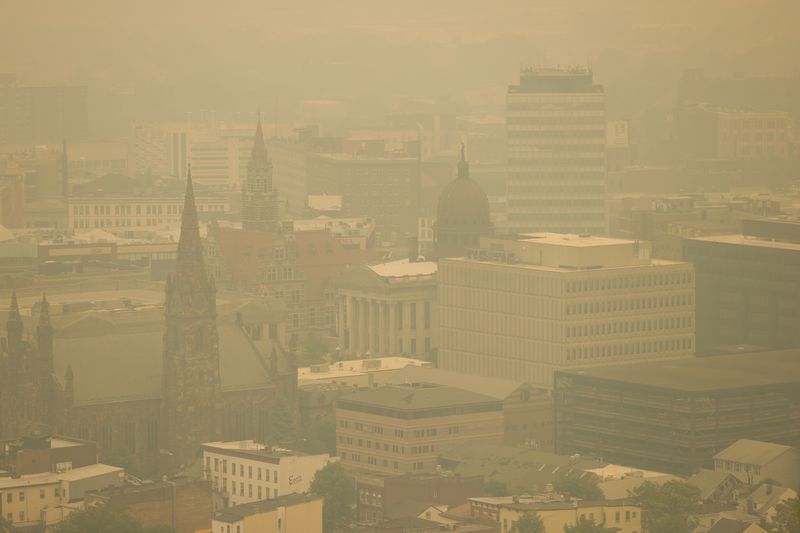
Wildfire smoke blankets downtown Paterson (Passaic County) on June 7th. Photo by Steve Hockstein/NJ Advance Media.

There is rarely a month in New Jersey where something interesting, exciting, and different than normal doesn’t occur in the weather and climate department. However, not often do you find a month like this past June where one is left with their head spinning as smoke from near and distant wildfires darkened the sky, creating exceptionally unhealthy air quality, where growing drought concerns were quieted in most locations by late-month downpours, where two tornadoes touched down, and with temperatures averaging cooler than normal for the second consecutive month. Strange, indeed.

June temperatures across the state averaged 67.8°. This was 2.5° below the 1991–2020 mean and tied as the 36th coolest June since 1895. The average daily maximum temperature of 79.0° was 2.0° below normal and ranks 40th coolest. The daily minimum averaged 56.6°, 3.0° below normal and was 35th coolest. The northern NJ climate division averaged 66.1° (-2.5°, 33rd coolest), the southern division averaged 68.9° (-2.5°, 36th coolest), and the coastal division averaged 68.2° (-2.3°, 45th coolest). Both May and June averaged below normal, the first such back-to-back occurrence in NJ since April and May 2020.

NJ June precipitation averaged 3.87”. This was 0.43” below normal, however, it ranks as the 53rd wettest of the past 129 years (or 77th driest) due to the skewed nature of the distribution of monthly precipitation over this period. The north averaged 5.13” (+0.52”, 29th wettest [101st driest]), the south 3.19” (-0.95”, 51st driest [79th wettest]), and the coast 2.20” (-1.65”, 28th driest [102nd wettest]).

Smoke Gets In Your Skies, and Another Mild One: May and Spring 2023 Recaps

June 7, 2023 - 6:43pm -- Dave Robinson

Wildfire smoke from western Canada contributed to a scenic sunrise on May 11 in Brigantine (Atlantic County). Photo courtesy of Connie Pyatt Photography.

When the headline for this monthly report alludes to hazy May skies that were frequently overhead, you know it was a quiet period weather-wise across the Garden State. Such was the case during the middle two weeks of May and at month’s end, with smoke from wildfires in western Canada frequently passing well overhead, followed by smoke from fires in Nova Scotia and a few in NJ. Otherwise, May temperatures were cooler than normal, and rainfall sparse.

The statewide average temperature of 59.3° was 1.9° below the 1991–2020 normal. This ranked as the 52nd coolest May since 1895. It was the coolest month compared to normal since January 2022. Following the third mildest April on record, May was only 4.0° milder than the previous month. This is the third smallest temperature difference on record between these two months. The average high temperature of 71.7° was 0.6° below normal, ranking 60th warmest and 68th coolest. The average low temperature of 46.9° was 3.3° below normal, ranking 26th coolest. The northern division averaged 57.8° (-2.1°, 50th coolest), the southern division 60.3° (-1.9°, 50th coolest), and the coastal division 59.6° (-1.4°, 63rd coolest).

Subscribe to RSS - smoke