Overview
The first month of 2024 provided a potpourri of weather happenings, including excessive rainfall and flooding, multiple snowfalls, frequent strong winds, frigid days, occasional warmth, and culminating with persistent dismal (aka damp, cloudy) conditions. Something for anyone or perhaps not favored conditions for most people. Totaling up the multiple precipitation episodes, this month emerged as the 6th wettest January on record dating back to 1895 (Table 1). It was the wettest January in 25 years and follows this past December, which was the wettest on record. The statewide 6.39” of rain and melted snow was 2.90” above the 1991–2020 normal. The northern climate division averaged 6.70” (+3.20”, 5th wettest), the southern division 6.18” (+2.71”, 7th wettest), and the coastal division 6.48” (+2.97”, 6th wettest; Figure 1).
| Rank | Year | January Avg. Precip. |
|---|---|---|
| 1 | 1979 | 9.12” |
| 2 | 1978 | 7.56” |
| 3 | 1999 | 7.19” |
| 4 | 1937 | 6.55” |
| 4 | 1936 | 6.55” |
| 6 | 2024 | 6.39” |
| 7 | 1915 | 6.30” |
| 8 | 1949 | 5.87” |
| 9 | 1996 | 5.73” |
| 10 | 1994 | 5.42” |
Table 1. The 10 wettest Januarys across NJ since 1895.
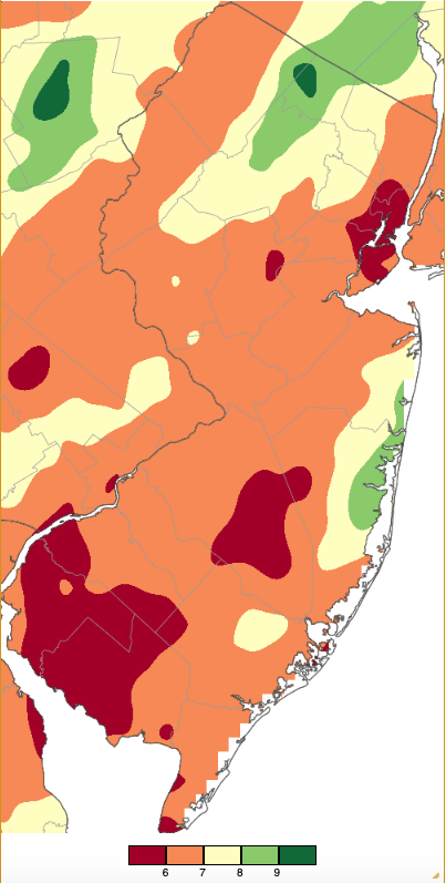
Figure 1. January 2024 precipitation across New Jersey based on a PRISM (Oregon State University) analysis generated using NWS Cooperative, CoCoRaHS, NJWxNet, and other professional weather station observations from approximately 7 AM on December 31, 2023 to 7 AM on January 31, 2024. Note the scale in inches at the bottom of the map. Totals range from 5.00”–5.99” (dark red) to 9.00”–9.99” (dark green).
January snowfall averaged 7.0” across NJ. This is just 0.2” below normal and ranks as the 53rd snowiest January of the past 130 years. Snow divisions include the north, which averaged 8.9” (-0.5”, 52nd snowiest), central coming in with 5.9” (-1.8”, 65th snowiest), and south with 6.6” (+0.9”, 43rd snowiest).
Temperatures fluctuated throughout the month, ultimately averaging 34.7° statewide. This was 3.0° above normal and ranks as the 20th mildest January. The north averaged 32.3° (+3.4°, 17th mildest), south 36.1° (+2.7°, 22nd mildest), and coast 36.9° (+2.5°, 24th mildest). The statewide average maximum of 42.0° was 1.7° above normal, ranking as the 30th warmest. The statewide average minimum of 27.4° was 4.2° above normal, ranking 16th mildest.
Precipitation and Storms
Much like this past December, the wettest NJ locations received over 2.5 times their normal January precipitation. The driest spots were over 2” above normal. Topping the list was Vernon Township (Sussex County) with 9.84”, followed by West Milford (Passaic) 9.62”, Berkeley Township (Ocean) 8.70”, Mine Hill Township (Morris) 8.68”, and Wayne (Passaic) 8.63”. Brigantine (Atlantic) saw the least with 5.58” followed by Upper Deerfield (Cumberland) 5.62”, Ocean City (Cape May) 5.68”, Long Beach Township (Ocean) 5.74”, Franklin Township (Somerset) 5.75”, and New Providence (Union) 5.78”.
Top monthly snowfall totals at CoCoRaHS locations were Montague (Sussex) 17.9”, Vernon Township 17.2” and 14.0” (two locations), Stillwater Township (Sussex) 14.5”, Andover (Sussex) 12.4”, Frelinghuysen Township (Warren) 12.4”, and Newton (Sussex) 12.3”.
The first storm of the month arrived during the afternoon of the 6th with rain in the south and snow in central and northern areas. Later that day, the snow turned to sleet and/or rain in central and northeast areas, with some light snow wrapping around the system as it departed on the 7th. Precipitation totals were as high as 1.72” in Berkeley Township, Point Pleasant Beach (Ocean) 1.54”, Wildwood Crest (Cape May) 1.47”, and Neptune (Monmouth) 1.47”. Of 244 CoCoRaHS reports, 126 received from 1.00”–1.72” (Figure 2).
Snow totals from this event exceeded 1.0” in 12 counties, with eight of these having at least one station with 4.0” or more (Figure 3, Table 2). High Point Ranger Station (Sussex) was buried under 14.0”, with eight other Sussex stations reporting double digit totals (Figure 4). A satellite image from the morning of the 8th shows where accumulating snow was deposited during the course of this storm.
The 6th was the first of 11 January days with wind gusts of 40 mph or higher at NJWxNet stations, five of which exceeded 50 mph. Extremes this day were 53 mph at Little Egg Harbor Township (Ocean), Atlantic City Marina (Atlantic) 50 mph, Sea Girt (Monmouth) 46 mph, and Harvey Cedars (Ocean) 43 mph.
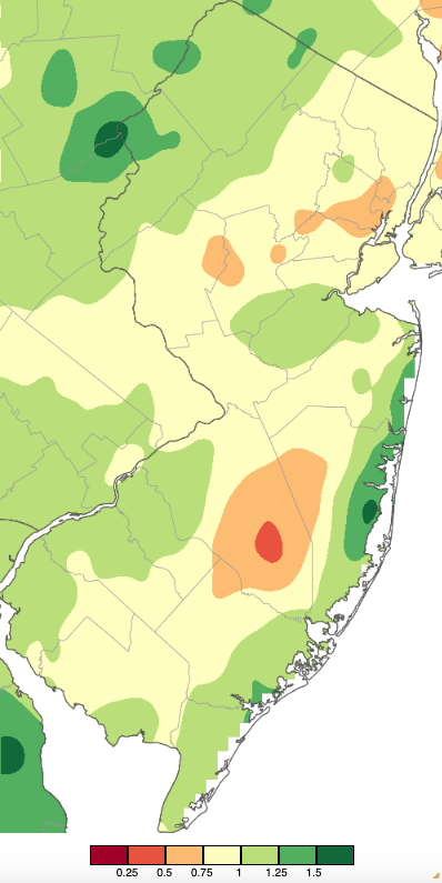
Figure 2. Precipitation across New Jersey from 7 AM on January 6th through 7 AM January 8th based on a PRISM (Oregon State University) analysis generated using NWS Cooperative, CoCoRaHS, NJWxNet, and other professional weather station observations. Note the scale in inches at the bottom of the map. Totals range from 0.00”–0.24” (dark red) to 1.50”–1.74” (dark green).
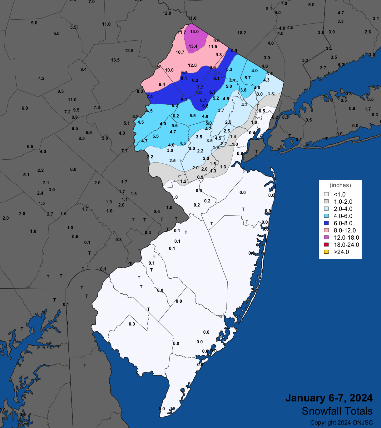
Figure 3. Snowfall from mid-day on January 6th through the morning of January 7th. Observations are from CoCoRaHS, NWS Cooperative Observer, and NWS Spotter reports.
| County | Location | Snowfall |
|---|---|---|
| Bergen | Franklin Lakes | 6.2” |
| Essex | Cedar Grove | 4.2” |
| Hunterdon | Califon | 5.6” |
| Morris | Green Pond | 8.1” |
| Passaic | West Milford Township | 5.3” |
| Somerset | Watchung | 4.8” |
| Sussex | High Point Ranger Station | 14.0” |
| Warren | Blairstown Township | 9.4” |
Table 2. Maximum snowfall for the January 6th to January 7th storm in counties where at least 4.0” fell. Observations are from CoCoRaHS, NWS Cooperative Observer, and NWS Spotter reports.
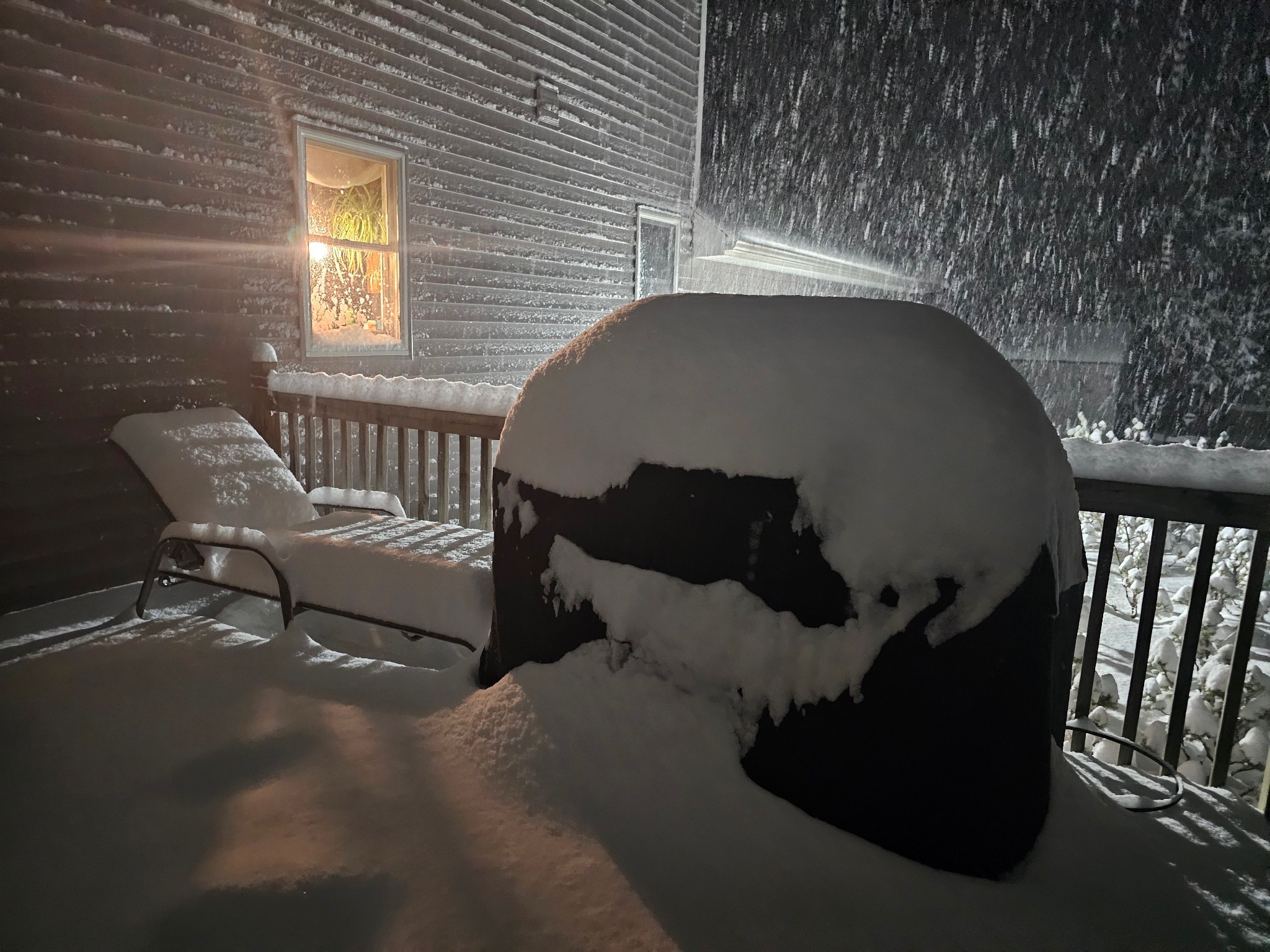
Figure 4. Heavy snow falling in a Wantage (Sussex) backyard the evening of January 6th where the storm total reached 13.5”(courtesy of Shawn Viggiano).
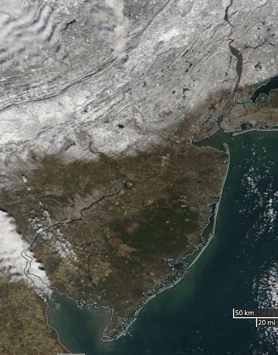
Figure 5. NASA MODIS visible satellite image on the morning of January 8th showing snow cover over New Jersey and surroundings north of approximately Route 1. The dark spot in west central NJ is unfrozen Round Valley Reservoir (Hunterdon). NJ skies are mostly cloud-free with some clouds lying in the southwest and others to the northwest over Pennsylvania’s Poconos.
The next storm arrived during the morning of the 9th with rain over most of NJ, though in the northwest, 1.3” of snow fell at Montague and 0.3” in Hardyston (Sussex) before turning to rain. Excessive rainfall and warm temperatures that melted most of the northern snowpack resulted in extensive flooding of streams and rivers, just about equaling the flooding in the third week of December. West Milford received 4.39”, Randolph Township (Morris) 4.18”, and Vernon Township 4.12”. Of 278 CoCoRaHS reports, 71 were from 3.00”–3.99”, 183 from 2.00”–2.99”, and 21 from the state minimum of 1.64” at Upper Deerfield to 1.99” (Figure 6). Major river flooding occurred on the Passaic River, where the river crested at Little Falls (Passaic) on the 11th at 9.71’. This was the 13th highest level in over a century and was just 0.56’ below the 9th highest level this past December 20th. The Raritan River at Bound Brook (Somerset) crested at 33.70’ on the 10th, the 10th highest level in over a century and remarkably just 0.02’ below the 9th highest of 33.72’ this past December 18th.
This storm was one of the windiest since Post Tropical Storm Sandy in 2012. Gusts at NJWxNet stations reached as high as 64 mph at Logan (Gloucester), Upper Deerfield 62 mph, Lower Alloways Creek Township (Salem) 60 mph, 50–59 mph at 16 locations, and 40–49 mph at 17 sites (Figure 7). The persistence of southeasterly winds pushed water up Delaware Bay into the tidal portion of the Delaware River, raising the water level at the Burlington (Burlington) gage to a record 11.99’ (period of record unavailable but at least 20 years; Figure 8). Flooding occurred along the river and in nearby tributaries. High winds also resulted in downed trees and powerlines at many locations across the state. Winds remained strong on the 10th, reaching 49 mph at Lower Alloways Creek Township, Little Egg Harbor Township 48 mph, Vernon Township 46 mph, and nine sites from 40–45 mph.
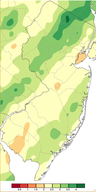
Figure 6. Precipitation across New Jersey from 7 AM on January 9th through 7 AM January 10th based on a PRISM (Oregon State University) analysis generated using NWS Cooperative, CoCoRaHS, NJWxNet, and other professional weather station observations. Note the scale in inches at the bottom of the map. Totals range from 0.00”–0.49” (dark red) to 4.00”–4.49” (dark green).
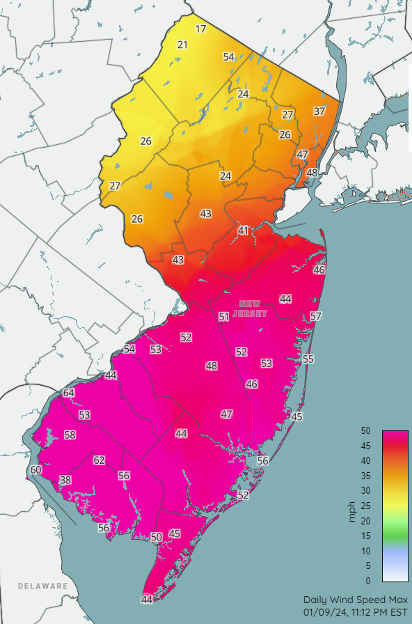
Figure 7. Peak wind gusts (mph) at NJWxNet stations on January 9th.
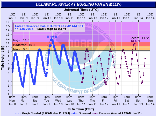
Figure 8. Tide heights at the Delaware River gage at Burlington from 8 AM on January 8th to 8 AM on January 11th (blue line) and projected heights onward to January 14th (purple line). A record-high level was observed early on January 10th (courtesy of NOAA National Ocean Service).
Yet more rain arrived during the evening of the 12th, mostly ending by dawn on the 13th. Of 272 CoCoRaHS reports, Berkeley Township caught the most with 1.87”, followed by Ocean Gate (Ocean) 1.83”, Pine Beach (Ocean) 1.72”, and Beachwood (Ocean) 1.69”. At 99 stations between 1.00”–1.87” fell, with Warren Township (Somerset) at 0.45” catching the least (Figure 9). Winds gusted to 41 mph at Lower Alloways Creek Township on the 12th, and on the 13th, 62 mph at Vernon Township and 40–49 mph at 18 locations.
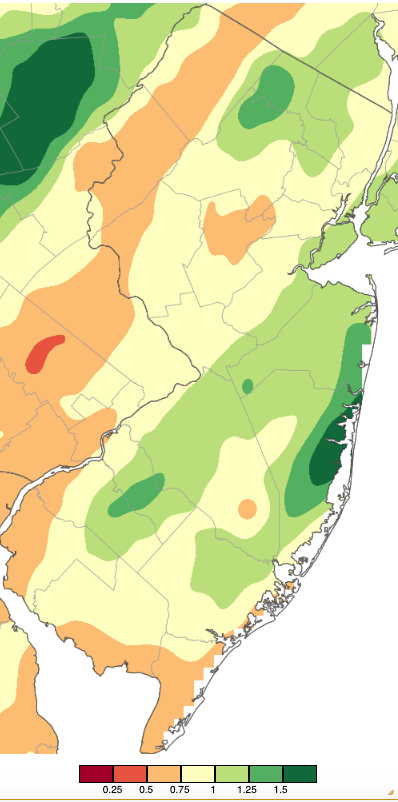
Figure 9. Precipitation across New Jersey from 7 AM on January 12th through 7 AM January 13th based on a PRISM (Oregon State University) analysis generated using NWS Cooperative, CoCoRaHS, NJWxNet, and other professional weather station observations. Note the scale in inches at the bottom of the map. Totals range from 0.00”–0.24” (dark red) to 1.50”–1.74” (dark green; same as Figure 2).
Cold air arrived on the 14th with scattered snow squalls and flurries and afternoon and evening winds gusting as high as 59 mph in Vernon Township, Lower Alloways Creek Township 51 mph, Fortescue (Cumberland) 50 mph, and 40–49 mph at 20 locations. This was followed by light snow moving into NJ first in the south and later up north on the evening of the 15th, later turning to sleet and freezing rain in some locations and light rain near the coast before ending as flurries on the 16th. Rain and melted snow amounted to no more than the 0.68” in Medford Lakes (Burlington) and 0.63” at Barnegat Light (Ocean). Every county had a location receiving at least 1.0” of snow, with nine counties seeing 3.0” or more (Figure 10). The top total in the state was 4.0” in Franklin (Sussex; Table 3). The peak wind gust in this event was 41 mph at High Point Monument (Sussex) on the 16th.
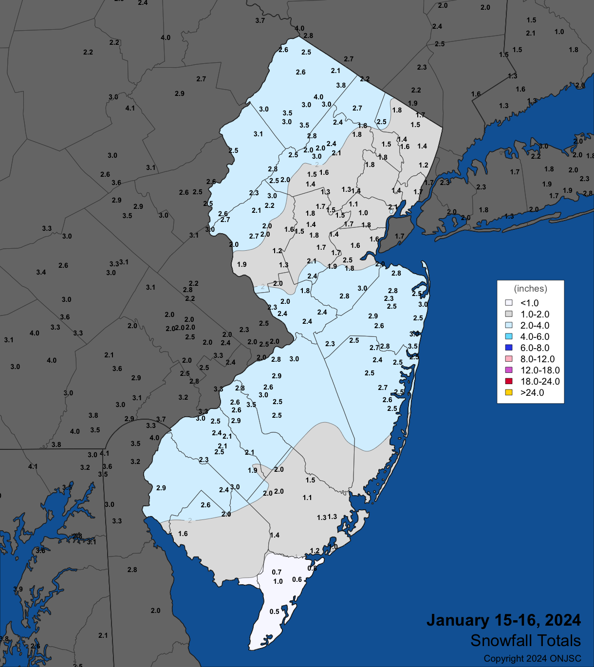
Figure 10. Snowfall from the evening of January 15th into the morning of January 16th. Observations are from CoCoRaHS, NWS Cooperative Observer, and NWS Spotter reports.
| County | Location | Snowfall |
|---|---|---|
| Burlington | 4 locations | 3.0” |
| Camden | Greentree | 3.5” |
| Gloucester | 3 locations | 3.0” |
| Hunterdon | Califon | 3.0” |
| Middlesex | Old Bridge Township | 3.0” |
| Monmouth | Manasquan | 3.5” |
| Morris | Mount Olive Township | 3.2” |
| Sussex | Franklin | 4.0” |
| Warren | Frelinghuysen Township | 3.1” |
Table 3. Maximum snowfall for the January 15th to January 16th storm in counties where at least 3.0” fell. Observations are from CoCoRaHS, NWS Cooperative Observer, and NWS Spotter reports.
Snow returned early on the 19th, bringing the first statewide snowfall since January 28–29, 2022. This was an all-snow event with melted totals only as high as 0.59” at Toms River (Ocean), Haddon Heights (Camden) 0.55”, and Moorestown (Burlington) 0.52”. Before snow tapered off in the late afternoon, an inch or more fell in every county and 4.0” or more in 10 counties, all in the southern half of the state (Figure 11). The top total of 6.5” was measured in Hopewell Township (Cumberland; Table 4).
Wind gusts following the storm on the 20th and 21st blew and drifted the snow and brought sub-zero wind chills across much of the state. Gusts on the 20th reached 48 mph at High Point Monument and 41–43 mph at three other NJWxNet locations. High Point Monument reached 52 mph and Wantage 47 mph on the 21st.
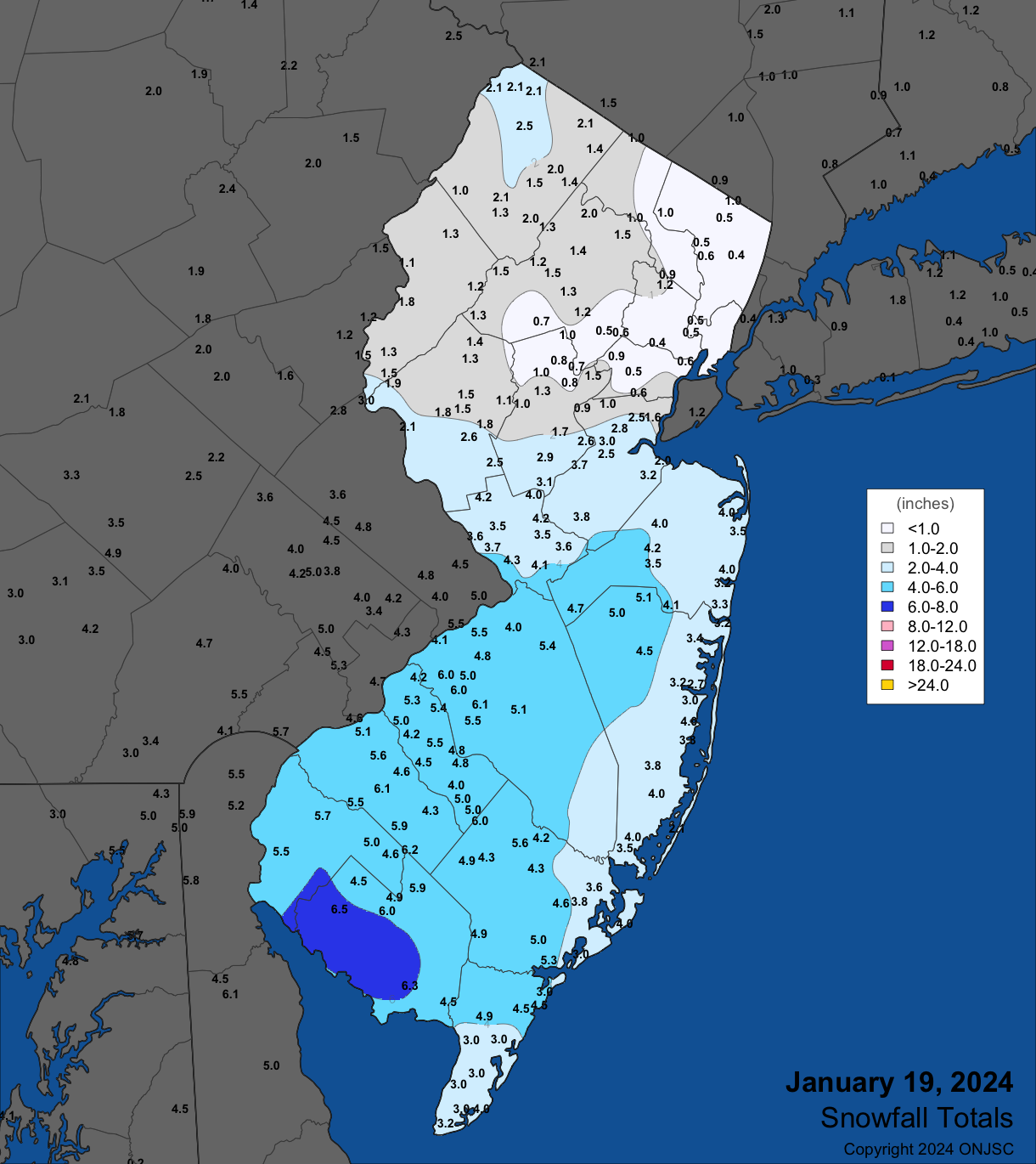
Figure 11. Snowfall from early morning to late afternoon January 19th. Observations are from CoCoRaHS, NWS Cooperative Observer, and NWS Spotter reports.
| County | Location | Snowfall |
|---|---|---|
| Atlantic | Hammonton | 6.0” |
| Burlington | Medford Township | 6.1” |
| Camden | Berlin | 6.0” |
| Cape May | Dennisville | 4.9” |
| Cumberland | Hopewell Township | 6.5” |
| Gloucester | Malaga | 6.2” |
| Mercer | Hamilton Township | 4.3” |
| Monmouth | Upper Freehold Township | 4.7” |
| Ocean | Jackson Township | 5.1” |
| Salem | Woodstown | 5.7” |
Table 4. Maximum snowfall for the January 19th storm in counties where at least 4.0” fell. Observations are from CoCoRaHS, NWS Cooperative Observer, and NWS Spotter reports.
Clear skies on the morning of the 21st resulted in satellite images showing the entire state to be snow covered (Figure 12). This was to be the last day with clear skies across NJ until February 3rd. While skies briefly cleared several times in the south, central and northern areas were locked in with clouds throughout. Accompanying the clouds was frequent light rain, drizzle, and fog. A persistent period of wet conditions from the 24th to early on the 27th saw 1.01” and 0.97”accumulate at Vernon Township (two locations) and 0.96” at both Montague and Knowlton Township (Warren). The wind gusted to 40 mph at Vernon Township on the 25th. Mid-morning solar radiation observations on the 26th exemplify the dreary conditions, with values about 10% of what would be expected on a sunny late-January morning except where skies were brighter right along the southeast coast (Figure 13). Also illustrating the persistent cloudy conditions late in the month were suppressed diurnal temperatures. For instance, Hillsborough-Duke (Somerset) saw diurnal ranges of 3°–8° on six of the last eight days of the month, with the other two days only achieving 12° and 14° ranges.
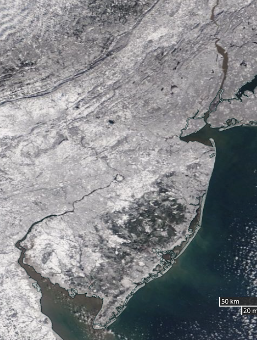
Figure 12. NASA MODIS visible satellite image on the morning of January 21st showing snow cover over all of New Jersey and surrounding states. The dark area in south Jersey is the Pinelands, where the coniferous trees “hide” the underlying snow cover from the satellite view.
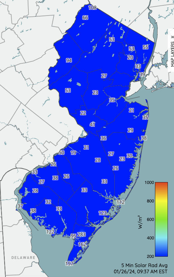
Figure 13. Solar radiation (in watts per meter squared) observed at NJWxNet stations at 9:37AM on January 26th. These are low values for this time of day, indicative of the thick cloud cover on this morning and over many days toward the end of the month. Under clear skies, values at this time of day in late January are approximately 350 watts per meter squared.
The final precipitation event of January included moderate to heavy rain early to mid-morning on the 28th, resuming at a lighter intensity during the afternoon and bringing 0.2” of snow to Wantage on the back end. Yet again, Vernon Township was among the wettest locations with 1.58”, followed by Roxbury Township (Morris) and another Vernon Township location both with 1.55” and Mine Hill Township 1.54”. Of 241 CoCoRaHS reports, 145 caught 1.00”–1.58”, and Toms River seeing the least with 0.57” (Figure 14). The wind gusted to 41 mph at Little Egg Harbor Township on the 28th. Onshore winds resulted in minor back-bay flooding from the 28th–31st.
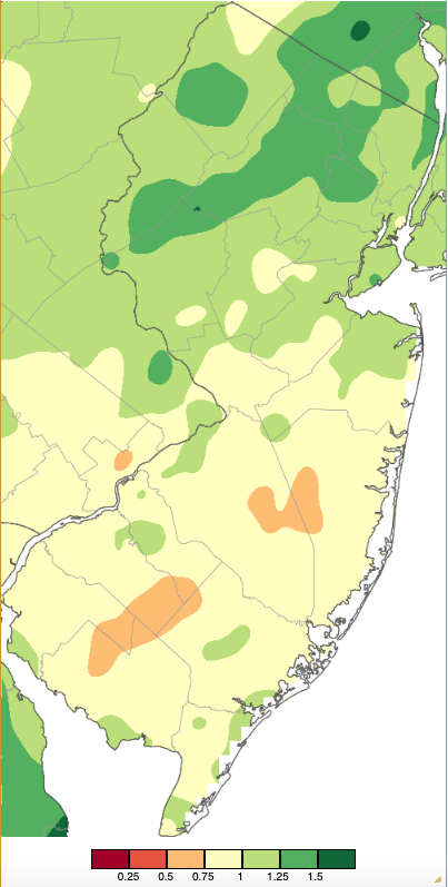
Figure 14. Precipitation across New Jersey from 7 AM on January 27th through 7 AM January 29th based on a PRISM (Oregon State University) analysis generated using NWS Cooperative, CoCoRaHS, NJWxNet, and other professional weather station observations. Note the scale in inches at the bottom of the map. Totals range from 0.00”–0.24” (dark red) to 1.50”–1.74” (dark green; same as Figures 2 and 9).
The highest barometric pressure readings across NJ in January were in the 30.50”–30.65” range on the 22nd, while the lowest were from 29.00”–29.10” in the wet and windy storm on the 10th.
Temperature
There were 14 January days when one or more of the 67 Rutgers NJ Weather Network station had a high temperature at or above 50°. Five of these saw temperatures of 60° or higher. Those days where the highs reached into the 50°–59° range included the 1st, 6th, 8th, 11th, 12th, 14th, 23rd, 24th, and 27th. The first day into the 60°s was the 9th, with West Deptford (Gloucester) up to 61°, four stations at 60° and 59 locations topping out in the 50°s. High Point Monument and Wantage were coolest at 48°, as much of the snow in the north melted, a situation that continued into the 10th with Mannington (Salem) up to 60° and all of the other NJWxNet stations from 51° (High Point Monument and Wantage) to 59°.
The 13th was one of the mildest days of January across much of NJ, with Howell (Monmouth), Jersey City (Hudson), and Oceanport (Monmouth) up to 62°, 23 stations either 60° or 61°, and the remainder of the network from 50° (High Point Monument) to 59° (Figure 15).
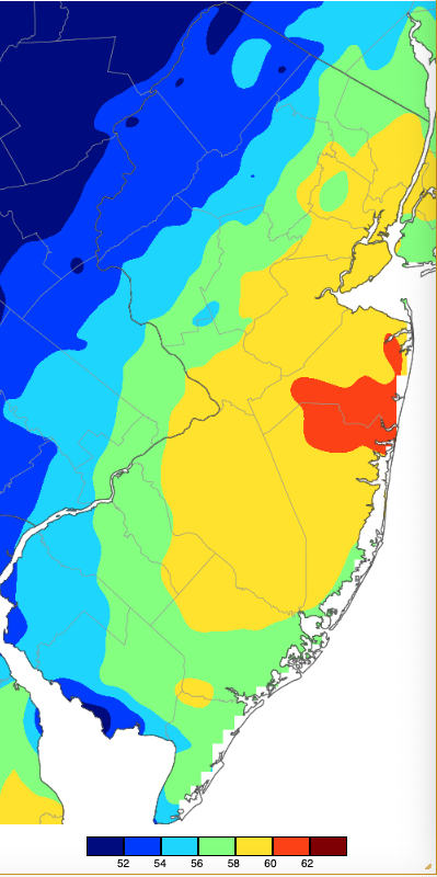
Figure 15. Maximum temperatures on January 13th based on a PRISM (Oregon State University) analysis generated using NWS, NJWxNet, and other professional weather stations. Note the 2° scale beneath the map.
A wide disparity in maximums occurred on the 24th when Woodbine (Cape May) rose to 59° while the high was only 35° in Wantage. Cape May Court House (Cape May) reached 63° on the 25th, with 14 stations 60°–62° and High Point Monument coolest at 47° (Figure 16). The mildest readings were in the south. The 26th again saw a wide range in high temperatures that included excessive warmth confined mainly to Cape May County where Cape May Court House reached a state monthly maximum of 72° followed by Dennis Township and Woodbine at 71°, and West Cape May 70°. Next mildest was 60° at Fortescue, while High Point Monument and High Point (Sussex) only made it to 42°.
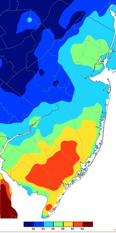
Figure 16. Maximum temperatures on January 25th based on a PRISM (Oregon State University) analysis generated using NWS, NJWxNet, and other professional weather stations.
There were three January days where no NJWxNet station reached the freezing point for a maximum. This included the 15th, 17th, and 20th. On the other hand, there were four days when not a single station dipped to or below the freezing point for a minimum. This included the 10th, 25th, 26th, and 27th.
Daily minimums dropped to 20° or lower at one or more NJWxNet station on seventeen January days. Eight of these saw lows of 10° or colder. The 11°–20° days included the 2nd to 6th, 8th, 9th, 14th, and 23rd. The 9th at Hillsborough-Duke exhibited a diurnal range of 39° from a low of 20° to high of 59°.
The 15th found High Point Monument down to 9°, with 18 locations from 12°–20°. The Monument was 10° on the 16th when 51 stations were 12°–20°. A state monthly minimum of 2° at Walpack (Sussex) on the 17th also included lows of 4° at Sandyston (Sussex) and High Point Monument, ten locations from 6°–10°, and the remaining 54 NJWxNet stations from 11°–18°. Fortescue, West Cape May, and Seaside Heights (Ocean) were at 18°. The 18th found Pequest (Warren) down to 4°, six sites 6°–10°, and 48 from 11°–20°. Fortescue was least cold at 29°. High Point Monument fell to 10° and 22 stations from 13°–20° on the 19th. Walpack took low honors on the 20th at 5°, with six stations 6°–10° and 57 from 11°–20°. High Point Monument was 8°, three stations 9°, and 55 from 11°–20° on the 21st. The coldest morning of January occurred on the 22nd when Walpack equaled its low mark of the 17th at 2°, Hopewell Township (Mercer) fell to 3°, ten locations reached 4°–10°, and 50 NJWxNet stations were 11°–20°. West Cape May was least cold at 25° (Figure 17).
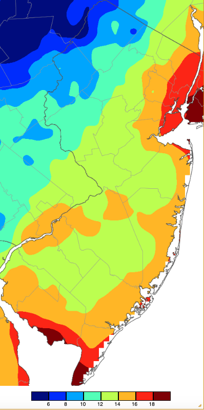
Figure 17. Minimum temperatures on January 17th based on a PRISM (Oregon State University) analysis generated using NWS, NJWxNet, and other professional weather stations.


