February Overview
The second month of 2022 and third month of winter continued a theme since December. Whether you call it a see saw, swing, or merry-go-round, it fits the theme of playground equipment as it never seemed any one particular variety of weather became established for all that long. More will be said about winter at the end of this report, but when it came to February, the end result was a somewhat warmer-than-normal month with about average precipitation and a dearth of snowfall. The statewide average temperature of 35.6° was 1.7° above the 1991–2020 normal, ranking as the 19th mildest since 1895. There was an above-average spread between the average high of 46.7° (+3.6°, 12th mildest) and low of 24.4° (-0.2°, 40th mildest), the 22.3-degree range being 3.8 degrees wider than normal. The north averaged 32.0° (+0.7°, 26th mildest), the south 37.7° (+2.2°, 16th mildest), and coast 37.9° (+1.9°, 18th mildest).
Rain and melted snow/sleet averaged 2.93”. This is 0.07” above normal and ranks as the 60th wettest/69th driest. The north averaged 3.45” (+0.66”, 44th wettest), south 2.62” (-0.27”, 49th driest), and coast 2.54” (-0.53”, 44th driest). More geographically specific, the far south was driest and the northwest wettest (Figure 1).
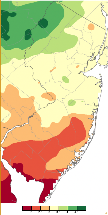
Figure 1. February 2022 precipitation across New Jersey based on a PRISM (Oregon State University) analysis generated using NWS Cooperative and CoCoRaHS observations from 7AM on January 31st to 7AM on February 28th. Note the scale in inches at the bottom of the map. Totals range from 1.50”–2.00” (dark red) to 4.50”–5.00” (dark green).
Snowfall averaged 2.1” across NJ. This is 6.1” below normal and ranks as the 25th least snowy February since 1895. The southern counties averaged 0.9” (Ocean and Burlington and southward: note the difference between the county breakdown for precipitation and temperature). This is 5.7” below normal and ranks as the 26th least snowy February. Central counties (Middlesex, Monmouth, Mercer, Hunterdon, Somerset, and Union) averaged 2.6” (-6.5”, 32nd least snowy). Counties to the north averaged 3.7” (-6.5”, 33rd least snowy).
Precipitation and Storms
Looking at individual stations across NJ, the most precipitation was observed in Stillwater Township (Sussex) with 4.86”, followed by Knowlton Township (Warren) at 4.60”, Newton (Sussex) 4.37”, Wantage (Sussex) 4.35”, and both Randolph (Morris) and Frelinghuysen (Warren) townships with 4.33”. On the dry side were the Cape May County locations of Wildwood Crest at 1.62”, three Lower Township sites with 1.71”, 1.82”, and 1.91”, Middle Township 1.84”, and Ocean City 1.98”. Upper Deerfield (Cumberland) only saw 1.88”. A number of southern locations had under an inch of snowfall, while top honors went to Sparta (Sussex) at 6.1”, Vernon Township (Sussex) 5.9”, Newton 5.5”, Blairstown (Warren) 5.2”, and both Frelinghuysen and Knowlton townships with 5.0”.
The morning of the 3rd began with light rain and foggy conditions across the Garden State. Fog, with light to moderate rain, continued into the evening. It was rain again during the morning and afternoon of the 4th, some of it freezing in the north, until a front moved through from north to south, rapidly dropping temperatures upwards of 20 degrees. Some light snow fell along the coast during the evening, with little or no accumulation. The northwest was, by a large margin, the wettest region of NJ during this extended event, with 2.54” accumulating in Knowlton Township, Frelinghuysen Township 2.47”, Hackettstown (Warren) and Blairstown each 2.46”, and Stillwater Township 2.41” (Figure 2). Of 225 CoCoRaHS reports 19 came in from 2.00”–2.54” and 145 from 1.00”–1.99”.
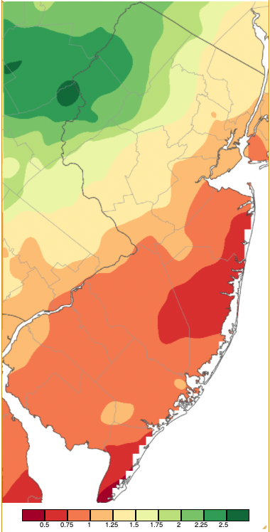
Figure 2. Precipitation across New Jersey from 7AM on February 3rd through 7AM February 5th based on a PRISM (Oregon State University) analysis generated using NWS Cooperative and CoCoRaHS observations. Note the scale in inches beneath the map.
Periods of light snow amounting to no more than a few tenths of an inch fell in the north during the morning of the 7th. The evening saw rain fall, especially in the southeast. Maurice River Township (Cumberland) received 1.06”, Wildwood Crest 0.83”, and three Lower Township sites caught 0.80”, 0.73”, and 0.69”.
The only plowable snow of the month fell in northern and central areas during the morning and afternoon of the 13th, later leaving a dusting further south. All 21 counties saw at least one location receive a measurable amount (0.1” or more), with 11 receiving 3” or more, and Sussex and Warren counties with 4.0”–5.0” totals (Figure 3). Hardwick (Warren) and Sparta each measured 5.0”, Highland Lakes (Sussex) 4.6”, Harmony (Warren) and Knowlton townships 4.5”, and Andover (Sussex) 4.4”. A visible satellite image on the 15th showed the distribution of snow cover across northern, central, and southwest Jersey locations but snow-free ground in the southeast (Figure 4).
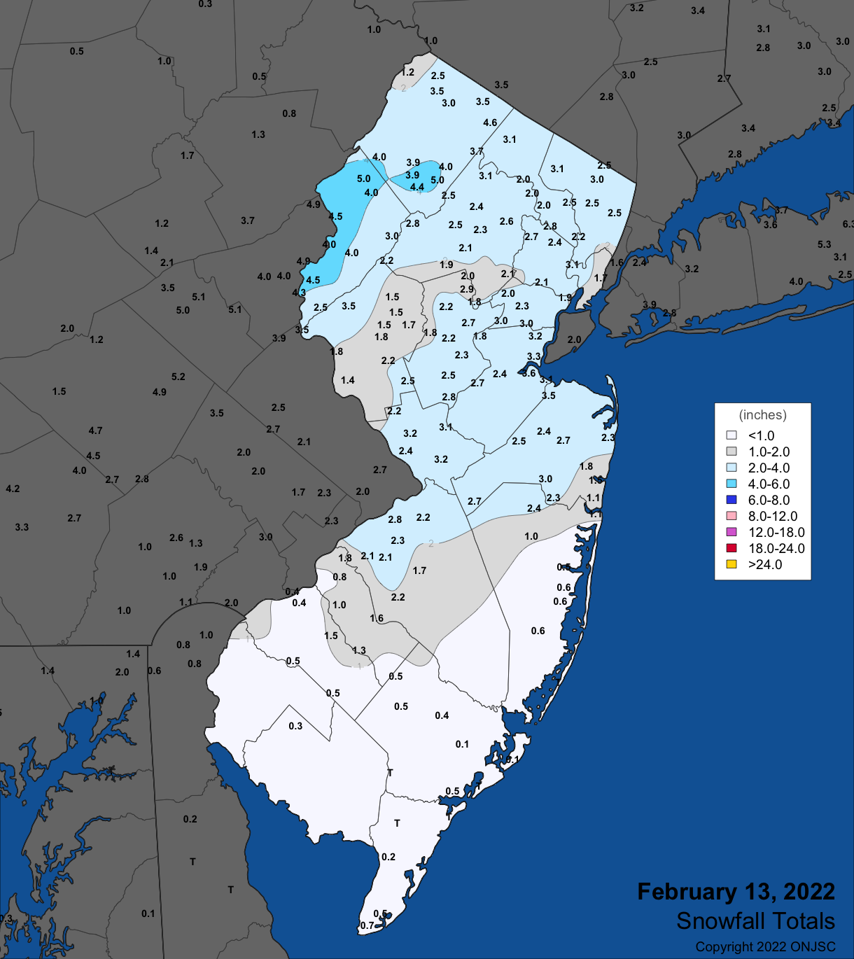
Figure 3. Snowfall on February 13th. Observations are from CoCoRaHS, NWS Cooperative Observer, and NWS Trained Spotter reports.
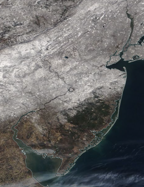
Figure 4. NASA MODIS visible satellite image showing snow cover across northern, central and parts of southwest NJ and surrounding areas to the east, north, and west on the morning of February 15th. The only cloud cover is seen along the central Delaware Bay coast and in the region close to Cape May (Cape May).
Rain commenced during the late evening of the 17th, culminating in a fast-moving squall line crossing the state in a few hours surrounding dawn on the 18th (Figure 5). In some areas, a burst of heavy rain was accompanied by lightning and rumbles of thunder. Total event precipitation included 1.17” in Randolph Township, Boonton (Morris) 1.08”, Denville (Morris) 1.05”, and Wayne (Passaic) 0.92”. Some 114 CoCoRaHS stations caught 0.50”–0.90”. Temperatures were exceedingly mild for February nighttime hours ahead of the frontal passage, quickly falling 20 to 25 degrees behind it as seen at Hillsborough-Duke (Somerset; Figure 6). With dry air rushing in, dew points fell well below freezing. Winds howled with High Point Monument (Sussex) gusting to 66 mph, Lower Alloways Creek Township (Salem) 59 mph, Little Egg Harbor Township (Ocean) 57 mph, Atlantic City Marina (Atlantic) and Harvey Cedars (Ocean) each 55 mph, Pennsauken (Camden) 54 mph, Moorestown (Burlington) 51 mph, Sea Girt (Monmouth) 50 mph, 9 NJWxNet stations from 45–49 mph, and 16 from 40–45 mph. Winds continued strong into the 19th, gusting to 54 mph at Lower Alloways Creek Township, Logan Township (Gloucester) and Seaside Heights (Ocean) each 53 mph, High Point Monument, Fortescue (Cumberland), and Harvey Cedars each 52 mph, Little Egg Harbor Township 51 mph, Pennsauken 50 mph, and 18 stations from 40–49 mph. Snow squalls on the afternoon of the 19th lightly whitened the ground in some locations.
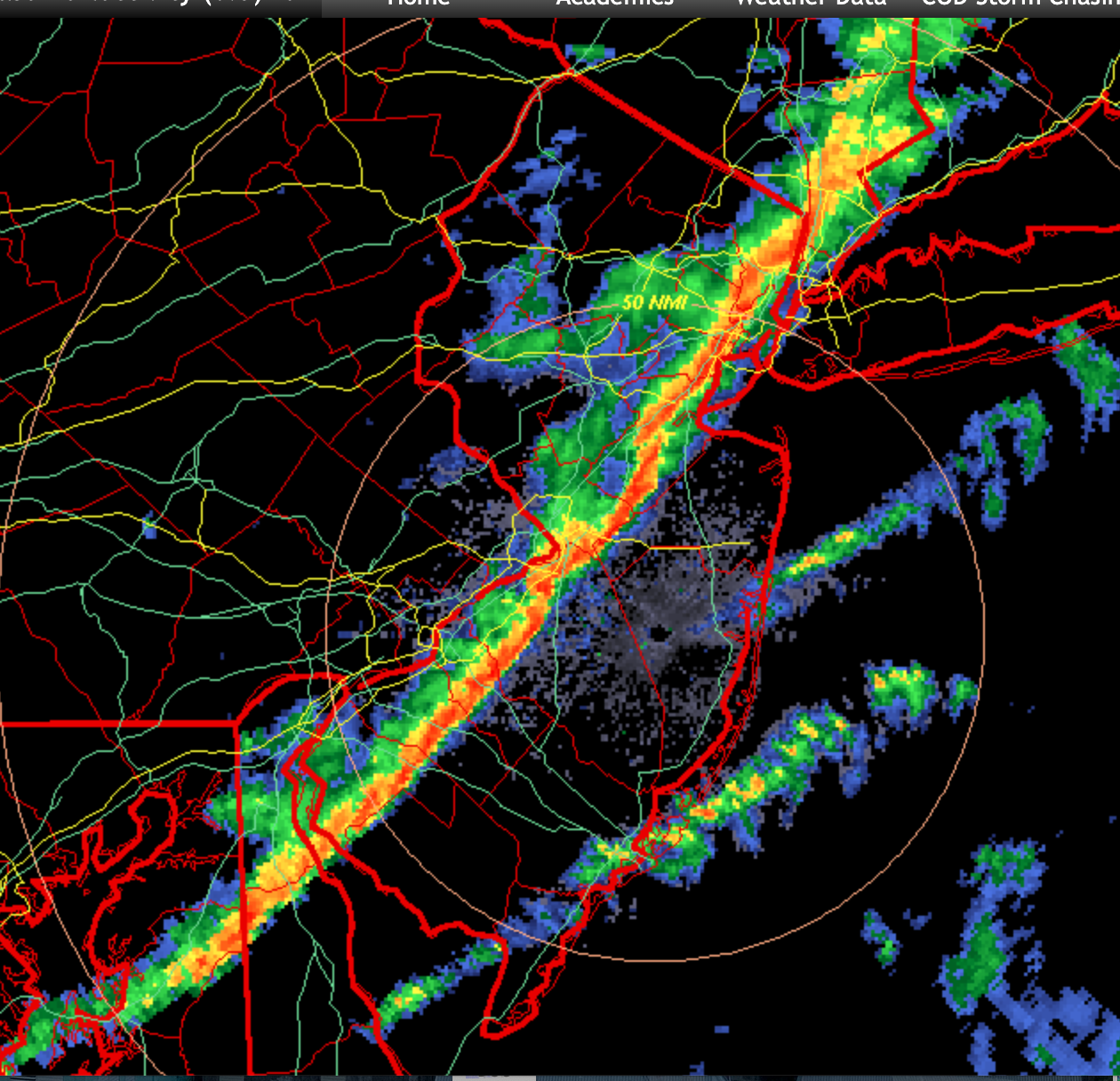
Figure 5. Radar image showing a squall line moving across the state at 6:24 AM on February 18th. Courtesy of the College of DuPage.
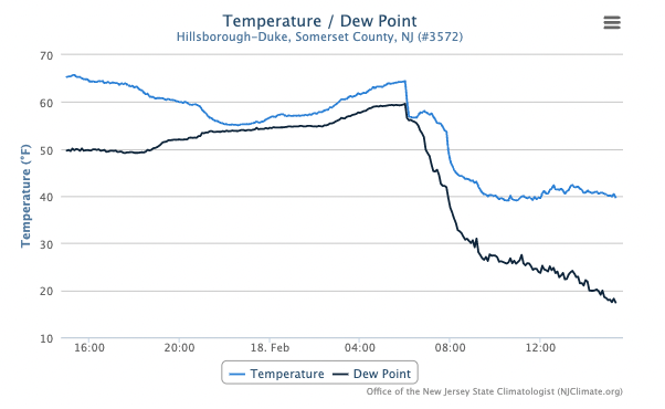
Figure 6. Time series of temperature and dew point temperature at Hillsborough-Duke from 3:25 PM on February 17th until 3:25 PM on the 18th.
Afternoon and evening rain on the 22nd fell mainly in the northwest, with Stillwater Township catching 0.66”, Knowlton Township 0.57”, and Mt. Arlington 0.52”. A mixed bag of precipitation fell across NJ from the evening of the 24th through the morning of the 25th. It was mainly rain in the south, a mix of sleet and freezing rain in central sections, and a little snow but mostly sleet topped with some freezing rain in the north. Brick (Ocean) came in with the most at 1.34”, followed by Manchester Township (Ocean) 1.33”, Ocean Township (Monmouth) 1.32”, and Cranford (Union) 1.31”. Of 225 CoCoRaHS reports 43 received 1.00”–1.34” and 185 from 0.50”–0.99”. Vernon Township received the most frozen precipitation with a snow/sleet depth of 1.9”, Newton and 1.6”, Bloomingdale (Passaic) 1.5”, Montague (Sussex) 1.4”, and 47 CoCoRaHS stations from 0.1”–1.3”.
The highest barometric pressure of February was reached on the 16th with readings from 30.70”–30.75”. The lowest pressure of the month followed on the 18th at 29.30”–29.45”. This rapid pressure transition explains the strong winds during this period.
In addition to 40+ mph gusts on the 18th and 19th, eight other days saw such gusts. They include the 4th with Atlantic City Marina up to 44 mph and Harvey Cedars 40 mph, the 14th with High Point Monument 42 mph, the 17th with Woodbine (Cape May) 41 mph, the 22nd with Atlantic City Marina 47 mph, Lower Alloways Creek Township 46 mph, and 5 sites 41–44 mph, the 23rd with High Point Monument 49 mph, Stewartsville (Warren) 41 mph, and Pennsauken 40 mph, the 24th with High Point Monument 40 mph, the 25th with High Point Monument 57 mph, Columbus (Burlington) 47 mph, and 6 sites 40–43 mph, and the 27th with High Point Monument 43 mph.
Temperature
There were nine February days when high temperatures at one or more NJWxNet station reached or exceeded 60°. The first day was the 4th when Mannington (Salem) reached 61° and three NJWxNet stations 60°. Daily highs were achieved just before a cold front moved southward through the state, leading to rapid temperature declines of 20 degrees, as illustrated by the time series at the Charlotteburg (Passaic) NJWxNet station (Figure 7). The next day, High Point Monument only made it to 15° for a high.
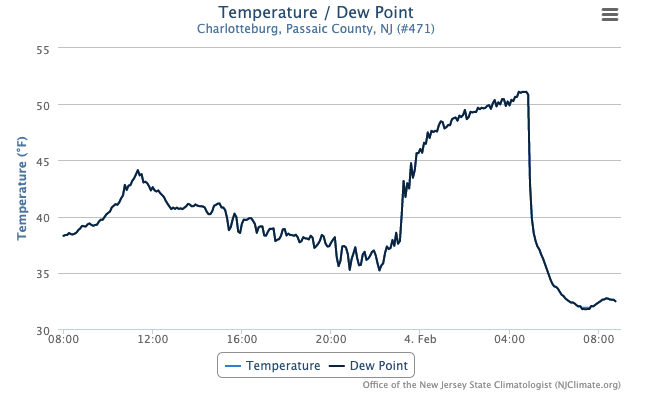
Figure 7. Time series of temperature and dew point temperature at Charlotteburg from 8:50 AM on February 3rd until 8:50 AM on the 4th. Here, moist conditions resulted in the dew point fluctuating in unison with the air temperature throughout the interval, thus is not easily seen in the figure.
Cape May Court House (Cape May) peaked at 60° on the 10th. The 11th found Piney Hollow (Gloucester), Red Lion (Burlington), Sicklerville (Camden), and West Deptford (Gloucester) at 63° and 18 stations from 60°–62°. Westerly winds on the 12th kept ocean-chilled air off the coast, permitting the temperature to rise to 66° at Atlantic City Marina, with Little Egg Harbor Township, West Creek (Ocean), and Woodbine each 65°, and 30 stations from 60°–64°. The 14th was the only day of the month where every NJWxNet station remained below freezing for the entire 24 hours, with the Atlantic City Marina, Lower Alloways Township, and Mannington the mildest at 30° and High Point Monument coldest with a 15° maximum.
It was back into the warmth on the 17th, with Sicklerville up to 71°, 18 stations at 69°, 19 from 65°–68°, and 14 from 60°–64°. West Cape May (Cape May) had the lowest state maximum of 50°. The 18th found eight stations up to 66° and 44 locations from 60°–65°. The diurnal temperature range on the 18th was 46 degrees at Walpack (Sussex; 62°/16°), and 45 degrees at Hillsborough-Duke (65°/20°).
A three-day stretch of mild conditions commenced on the 21st with Hammonton (Atlantic), Red Lion, and Sicklerville at 64° and 24 stations from 60°–63°. The warmth was centered over inland portions of the northern coast on the 22nd with Berkeley Township (Ocean), Holmdel (Monmouth), and Howell (Monmouth) each at 67°, Toms River (Ocean) 66°, and 40 stations from 60°–65°. The 23rd was the warmest day of February with Egg Harbor Township (Atlantic), Sicklerville, and West Creek all at 73° and 35 stations from 70°–72° (Figure 8). High Point Monument at 58° and Fortescue’s 59° were the state’s coolest highs. Statewide, the morning low was 22° at Vernon Township and High Point Monument, thus a 51 degree range from maximum to minimum occurred within NJ on the 23rd.
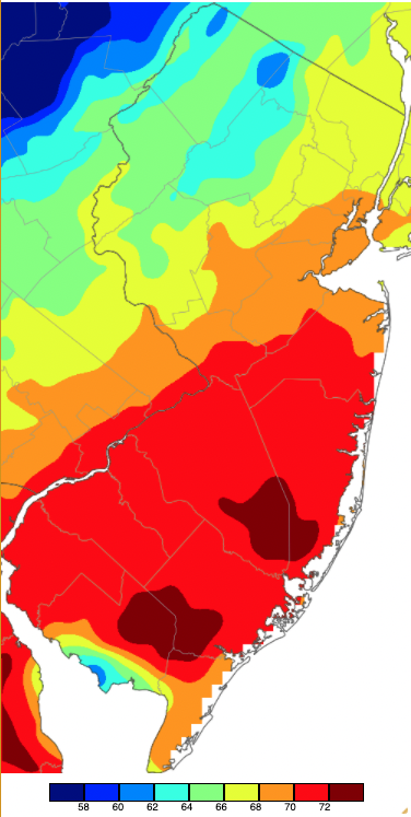
Figure 8. Maximum temperatures on February 23rd based on a PRISM (Oregon State University) analysis generated using NWS, NJWxNet, and other professional weather stations. Note the 2 degree increment scale beneath the map.
High Point Monument had high temperatures at 32° or colder on 14 February days. Meanwhile, six NJWxNet stations at or near the south Jersey coast had just one day, the 14th, with highs below freezing.
Seven February days saw the thermometer dip to 10° or colder at a WxNet station. The coldest low of the month was the -4° on the 1st at both Sandyston (Sussex) and Walpack. Basking Ridge (Somerset) was -1°, Hopewell Township (Mercer), Pequest (Warren) and Charlotteburg were each 0°, and 14 sites were from 1°–10°. Seaside Heights had the mildest low at 33°. Three NJWxNet stations fell to 33° on the 3rd, the lowest in the state and the only day this month when the freezing mark was not reached anywhere. Yet just two days later, the 5th found High Point (Sussex) and High Point Monument each at 6° and four station from 8°–10°. Sandyston and High Point fell to 3° on the 6th, with 11 locations from 4°–10°.
Three consecutive days of sub-10° lows began on the 14th, with Pequest at 3°, High Point Monument 4°, and 14 stations from 5°–10°. The overall coldest day of the month was the 15th when Pequest fell to -2°, Hopewell Township -1°, Sandyston 0°, and 31 locations from 1°–10° (Figure 9). West Cape May was least cold at 24°. Hopewell Township made it to 8° on the 16th with six sites at 9° or 10°. On the 20th, Sandyston, Wantage, and High Point bottomed out at 9°.
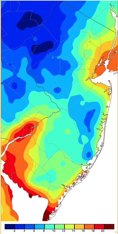
Figure 9. Minimum temperatures on February 15th based on a PRISM (Oregon State University) analysis generated using NWS, NJWxNet, and other professional weather stations. Note the in 2 degree increment scale beneath the map.
As colder air moved into NJ during the evening of the 23rd, a wide range in temperatures occurred from 32° at High Point Monument (not shown) to 67° at multiple south Jersey locations (Figure 10).
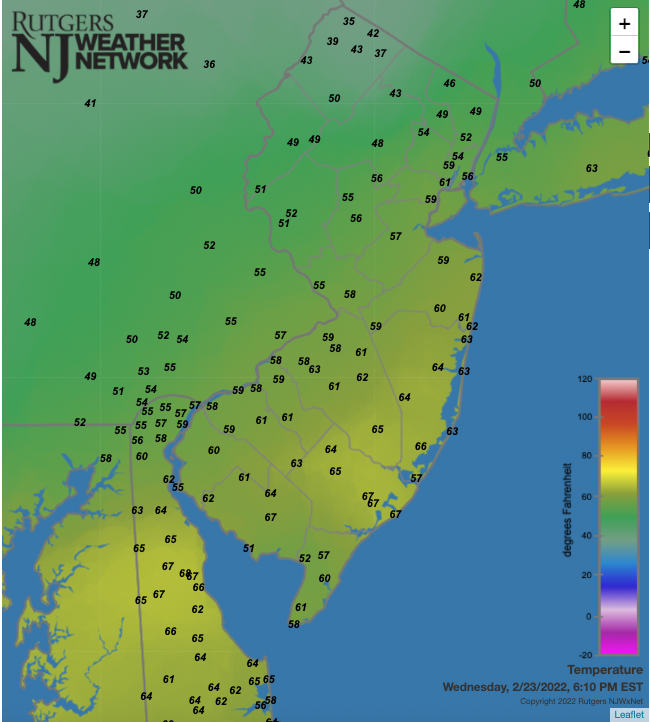
Figure 10. Temperatures across NJ and nearby states at 6:10 PM on February 23rd. Observations are from NJWxNet, National Weather Service, and Delaware Environmental Observing System stations.
Winter Overview
With above-normal temperatures in December and February and a below normal January, the overall winter average of 35.2° was 1.1° above normal. This ranks as the 16th mildest dating back 128 winters.
The 6th driest December on record and close-to-average January and February conditions resulted in statewide precipitation averaging 2.93” below normal for the season. The 7.69” total ranks as the 18st driest winter on record. Central regions saw the most precipitation, with drier conditions along the northern border and in the southwest (Figure 11). Princeton (Mercer) with 10.13” received the most winter precipitation followed by Howell (Monmouth) 9.81”, Old Bridge (Middlesex) 9.74”, two Woodbridge (Middlesex) stations with 9.65” and 9.73, and Chester (Morris) 9.24”. On the short end was Buena Vista (Atlantic) with 6.63”, Folsom (Atlantic) 6.69”, Franklin Township (Gloucester) 6.74”, Ocean City (Cape May) 7.13”, and Woodstown (Salem) 7.20”.
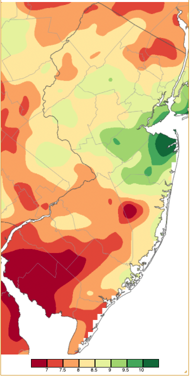
Figure 11. Winter 2021/2022 precipitation across New Jersey based on a PRISM (Oregon State University) analysis generated using NWS Cooperative and CoCoRaHS observations. Note the scale in inches at the bottom of the map. Totals range from 6.50”–7.00” (dark red) to 10.00”–10.50” (dark green).
Snowfall was abundant in January, especially in the southeast, but meager statewide in December and February. This left a snow-season-to-date average of 20.4”, which is 4.8” below normal. The most snow fell in Galloway (Atlantic) with stations reporting 36.0” and 35.3”. This is followed by Brigantine (Atlantic) 32.2”, Stafford Township (Ocean) 30.7”, Berkeley Township (Ocean) 26.7”, Ocean City 26.5”, and Maurice River Township (Cumberland) 25.3”. Lowest snowfall totals included Woodstown 7.7”, Manville (Somerset) 12.5”, Hopewell Township (Mercer) 12.6”, Lawrence Township (Mercer) 12.7”, Bernards Township (Somerset) 13.1”, East Brunswick (Middlesex) 13.2”, and Maplewood (Essex) 13.3”.


