May Overview
As was seen earlier this spring, rainfall was quite persistent during a good portion of May. However, unlike April, it was not just a matter of frequency but ultimately, quantity that made for soggy conditions in the fifth month of 2019. The statewide average precipitation was 6.70”, which is 2.71” above the 1981–2010 mean. This made for the 9th wettest May since records commenced in 1895 (Table 1). The northern half of NJ was wettest, averaging 8.69” (+4.35”), making it the 3rd wettest on record. Only May 1989 (10.13”) and 1984 (9.79”) saw more rain. The south averaged 5.52” (+1.72”), ranking 17th wettest.
| Rank | Year | May Precip. |
|---|---|---|
| 1 | 1989 | 8.43" |
| 2 | 1948 | 8.38" |
| 3 | 1984 | 8.30" |
| 4 | 1990 | 7.62" |
| 5 | 1947 | 7.08" |
| 6 | 1978 | 7.04" |
| 7 | 1908 | 6.88" |
| 8 | 1898 | 6.77" |
| 9 | 2019 | 6.70" |
| 10 | 2017 | 6.51" |
Table 1. The 10 wettest Mays across NJ since 1895.
Based on observations from 62 NJWxNet stations, there were only two calendar days (22nd and 25th) without measurable (0.01”) rainfall at any location. Three days saw a maximum of 0.01”–0.10” at one or more stations, nine with a maximum between 0.11”–0.25”, and eleven topping out from 0.26”–0.99”, while on six days one or more station received an inch or greater.
The wet conditions were accompanied by above average temperatures. The 62.7° statewide average was 2.1° above the 1981–2010 mean. This ranked as the 19th mildest May on record (tied with 1985). However, it is only the 8th warmest May since 2004. Ten of the past 12 months have been above average.
Precipitation and Storms
Given the often showery nature of the May rainfall, not just daily but also monthly totals varied quite widely across the Garden State. Some 32 CoCoRaHS and NJWxNet stations totaled more than 10.00”, while five received less than 4.00”. Top marks went to a station in Lebanon (Hunterdon County) with 12.77”. Two other stations in that community received 11.39” and 11.12”. Other hefty totals included 12.06” in Washington Township (Morris), Bridgewater (Somerset) 11.73”, Clinton (Hunterdon) 11.69”, Morristown (Morris) 11.66”, Washington (Warren) 11.57”, three Blairstown (Warren) stations at 11.48”, 11.35”, and 10.95”, Rockaway (Morris) 11.23”, and Andover (Sussex) 11.22”. The least amount of May rainfall was observed at Atlantic City Marina (Atlantic) with 3.43”. This was followed by 3.60” at Weymouth (Atlantic), Atlantic City Airport in Pomona (Atlantic) 3.80”, Egg Harbor Township (Atlantic) 3.92”, Absecon (Atlantic) 3.98”, and 4.07” at both Pittsgrove (Salem) and Woodbine (Cape May).
Evening showers in Cape May County on the 2nd kicked off the rainy month. Four Lower Township stations caught 0.80”, 0.65”, 0.63”, and 0.56”, while Wildwood Crest saw 0.46”. Scattered showers were also observed in west central areas. Early morning thunderstorms on the 4th brought 1.02” to Mendham (Morris), Little Falls (Passaic) 0.99”, Randolph (Morris) 0.85”, and Peapack-Gladstone (Somerset) 0.85”. Widespread moderate to heavy rain fell from late on the 4th until early on the 6th. Some 35 CoCoRaHS stations received over 2.00”, topped by Washington (Warren) with 3.02”, Washington Township (Warren) 2.69”, Ocean Township (Monmouth) 2.55”, and Phillipsburg (Warren) 2.51”. Another 155 stations came in between 1.00”–1.99”. Toms River (Ocean) and Lower Township, each with 0.42”, saw the least.
The evening of the 7th saw a line of thunderstorms drop southward from northern areas before stalling out in the mid-south during the pre-dawn hours. Sayreville (Middlesex) caught 1.27”, Bridgewater 1.15”, Metuchen (Middlesex) 1.04”, and Edison (Middlesex) and Evesham (Burlington) each came in at 1.03” (Figure 1). No rain fell in far southern reaches.
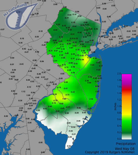
Figure 1. Rainfall from about 7AM on May 7th to 7AM on May 8th. Observations are from CoCoRaHS stations.
A prolonged rainfall event of varying intensities began late on the 11th and ended late on the 13th. The heaviest rain fell during the daylight hours of both the 12th and 13th. Of the 229 CoCoRaHS stations reporting, 149 received 2.00”–2.99” and 80 from 1.01”–1.99”. Leading the way was Red Bank (Monmouth) at 2.99”, followed by three Blairstown locations with 2.94”, 2.84”, and 2.82”, Madison (Morris) 2.88”, North Brunswick (Middlesex) 2.78”, and New Providence (Union) 2.76”. Middle Township (Cape May) and Hammonton (Atlantic) had 1.01”. Winds gusted to 43 mph at High Point Monument (Sussex) on the 11th, with this highest elevation NJ station up to 40 mph on the 12th, while coastal stations reached 44 mph at Harvey Cedars (Ocean), Sea Girt (Monmouth) 43 mph, and Seaside Heights (Ocean) and Fortescue (Salem) each up to 41 mph.
Some rain fell on either side of dawn on the 19th. It resumed in the evening into the predawn of the 20th with strong thunderstorms that brought down trees in Sussex and Morris counties. Blairstown was again a wet spot with stations catching 1.61”, 1.57”, 1.48”, and 1.47”. Union (Hunterdon) came in at 1.42” and Washington Township (Morris) saw 1.36”. 60 stations came in from 0.50”–1.30”. On the 20th, scattered afternoon and evening thunderstorms in the south brought 0.56” to Galloway (Atlantic) and 0.56” and 0.55” to two sites in Port Republic (Atlantic). A wind gust of 42 mph was observed at Fortescue.
Yet another rainy day on the 23rd saw predawn thunderstorms in central and northern locations and widespread afternoon showers. Three Lebanon sites saw 1.17”, 1.08”, and 0.91”, with Clinton at 1.10”, Phillipsburg 1.09”, and Washington Township (Warren) 1.08”. 79 of 220 CoCoRaHS reports were between 0.50”–1.17”. Behind this system, the wind gusted to 46 mph at High Point Monument on the 24th.
Thunderstorms occurred in the south from the evening of the 25th into the predawn hours of the 26th. Middle Township saw 0.70” and Wildwood Crest 0.65”. Thunderstorms returned to this area and also in some northern locations during the evening of the 26th. Lower Township saw 1.09”, two Wildwood Crest stations caught 0.97” and 0.94”, four Lower Township stations at 0.90”, 0.87”, and 0.80”, and 0.66” and 0.79” at two Bernards Township (Somerset) locations. Trees toppled onto cars in a few Bergen County locations.
Scattered showers fell in northern and central areas on the morning of the 28th, however, the main event came later in the afternoon into the evening with severe weather in portions of north Jersey and isolated heavy rain in part of Ocean County late in the evening. Several severe thunderstorm cells dropped out of southern Sussex County and moved southeast into Union County, bringing heavy rain, hail, strong winds, and the first tornado of 2019 to the state. The tornado struck the community of Stanhope (Sussex) at 8:30 PM. The National Weather Service reported that it was an EF1 storm with a 100 mph maximum wind. It was on the ground for one to one and a half minutes, covering a discontinuous path of 1.2 miles, and having a maximum width of 350 yards. Trees were brought down onto homes and cars, and wind damage was reported at Lenape Valley High School. Fortunately, no injuries were reported from the tornado, nor from tree-toppling straight-line winds associated with these strong cells. Power outages were common. The strongest wind gusts in the NJWxNet were observed farther south in Fortescue at 49 mph and in Berkeley Township (Ocean) at 45 mph. Hail up to a half inch in diameter was observed with the two northern cells. The precipitation map (Figure 2) shows the path of the strongest cells in the north and the isolated heavy area in Ocean County. The latter includes reports of 2.93” in Lacey Township and 2.72” in Berkeley Township. Other heavy totals included 2.65” in Ewing Township (Mercer), Morristown 1.66”, and Andover 1.65”. The map also shows scattered areas with little to no rain.
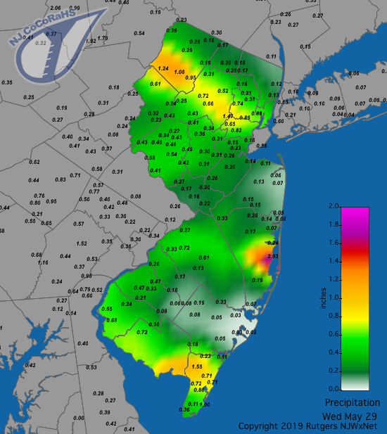
Figure 2. Rainfall from about 7AM on May 28th to 7AM on May 29th. Observations are from CoCoRaHS stations.
More strong thunderstorms arrived in the late afternoon and evening of the 29th. Rainfall was particularly heavy in west central and northwest areas (Figure 3). Hamilton (Mercer) caught 2.54”, Ewing Township again was doused with 2.51” and 2.04”, Blairstown stations saw 2.27”, 2.08”, and 2.00”, Princeton (Mercer) had 2.19” and 2.00”, and West Milford (Passaic) 2.14”. Of 229 CoCoRaHS reports, 91 were between 1.00”–1.99” and 95 from 0.50”–0.99”. Small hail was reported in Warren, Hunterdon, and Mercer counties, with small stream flooding, treefalls, and power outages in Mercer County. Wind gusts reached 49 mph for the second consecutive day at Fortescue, 43 mph at Lower Alloways Creek Township (Salem), Sea Girt (Monmouth) 41 mph, and Vineland (Cumberland) 40 mph.
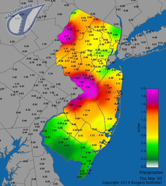
Figure 3. Rainfall from about 7AM on May 29th to 7AM on May 30th. Observations are from CoCoRaHS stations.
Yet another round of strong storms visited the northern half of the state during the late afternoon and evening of the 30th. The storms brought down some trees in Sussex County, with some stream and street flooding in the areas of heaviest rain. Bridgewater reports included 2.10”, 2.05”, and 1.68”, Somerville (Somerset) saw 2.06”, Manville (Somerset) 1.92”, and Rockaway 1.91” (Figure 4). Of the 224 CoCoRaHS reports, 77 were between 1.00”–2.10” and 70 from 0.50”–0.99”. Scattered areas in the south received less than 0.20”.
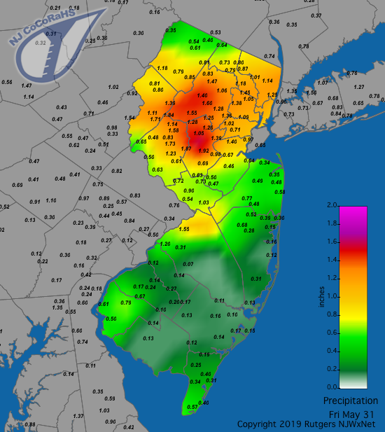
Figure 4. Rainfall from about 7AM on May 30th to 7AM on May 31st. Observations are from CoCoRaHS stations.
The highest barometric pressure in May was close to 30.45” on the 1st. The lowest pressure was in the 29.60”–29.65” range on the 29th.
Temperature
An examination of the 65 NJWxNet stations reporting temperatures in May found seven afternoons with maximums topping out at 85° or higher at one or more locations. There were 16 days with minimum temperatures of 45° or lower somewhere in the state, with the 30°s reached on five days.
On the warm end, the 2nd saw Oswego Lake (Burlington) reach 86° and three other locations at 85°. Howell (Monmouth) topped out at 89° on the 17th, with Sicklerville (Camden) at 85°. Nine locations got to 87° on the 19th, with 15 trailing closely at 85° or 86°. The first 90° afternoon of the season occurred on the 20th, with Berkeley Township, Moorestown (Burlington), Point Pleasant (Ocean), and Sicklerville up to 91° and six other stations at 90°. Hamilton (Mercer), Berkeley Township, Jersey City (Hudson), and Toms River hit 90° on the 26th, with 54 stations from 85°–89°. High Point Monument and Fortescue were coolest at 79°. An impressive range of maximum temperatures occurred on the 29th, with Cape May Courthouse (Cape May) up to 91°, nine stations at 90°, and 16 from 85°–89°, while High Point Monument only made it to 65°. The 30th found Mannington (Salem), Sewell (Gloucester), and South Harrison (Gloucester) at 86°, while Ramsey (Bergen) and Jersey City (Hudson) reached just 67°.
Clouds, rain and an onshore breeze on the 5th made for cool highs and especially small diurnal temperature ranges. This included a maximum of 53° and minimum of 50° at both Harvey Cedars and Sea Girt.
Lowest station minimums of 41°–45° were observed somewhere in NJ on the 1st, 2nd, 6th, 7th, 9th, 11th, 16th, 17th, 18th, 21st, and 25th. High Point Monument and Walpack (Sussex) were each within this range on six of the eleven days, with other northwest Jersey stations occasionally at this level too. Only on the 7th was the Pinelands station at Hammonton lowest and alone at 45°. The five colder days began, interestingly enough, in mid-month, with the 12th seeing High Point Monument down to 34°, High Point (Sussex) 35°, and Sandyston (Sussex) 38°. On the 13th, these three stations came in just as on the previous day, with three other locations at 39°. The Monument was 37° and High Point 38° on the 14th. Overall, the 15th saw the coolest lows of the month, with Sandyston and Pequest (Warren) at 35°, Basking Ridge (Somerset) 36°, High Point Monument and Walpack each 37°, eleven sites from 38°–39°, and 45 others from 40°–45°. West Cape May (Cape May) was warmest at 50°. The last 30°s of the month was on the 22nd, with Walpack at 34°, Sandyston 36°, Pequest 38°, Hopewell Township (Mercer) 39°, and 25 locations from 40°–45°. Lower Alloways Creek Township was mildest at 57°.
With no freezing temperatures observed in May and none expected until next fall, it is now appropriate to examine the length of time between the first fall 2018 and last spring 2019 freeze across NJ. The NJWxNet locations with the shortest freeze season were Lower Alloways Creek Township, West Cape May, Atlantic City Marina, and Harvey Cedars, each with a 142-day interval from first to last freeze (November 12–April 2 at the first two locations and November 11–April 1 at the latter two). These are coastal locations, where waters are slow to cool in the fall and most often modify the coldest air reaching the coast in all seasons. A much longer season was achieved at Pequest, Basking Ridge, and Walpack, each with a 195-day interval from first to last freeze (October 17–April 29). These are areas where cold air drains into these valley locations on clear, calm nights.
Spring 2019 Overview
As is always the case in a transition season, cold and warm conditions often battled it out for dominance this past spring. March saw wintry conditions, particularly at the start, and temperatures averaged below normal. April was the 4th mildest on record, with May also in the upper quartile for warmth. Together, this resulted in an average spring temperature of 52.3°. This is 1.6° above average and the 14th warmest since 1895.
Precipitation (rain and melted snow) was just slightly below average in March and April but well above average in May. This led to a statewide seasonal average of 14.49”. This is 2.40” above average and the 17th wettest spring on record. The wettest locations were Washington Township (Morris) with 20.70” and Lebanon (Hunterdon) at 20.68”. The driest spots included Buena Vista (Atlantic) with 11.90” and Monroe Township (Gloucester) at 12.16”. Snowfall was above average in March, but not nearly as much fell as in March 2018. No measurable snow fell later in the season.


