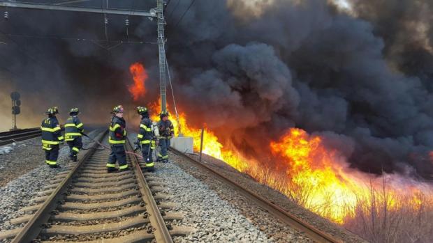
Firefighters battle a brush fire along the Northeast Corridor rail line in Secaucus on April 19 (photo by Joe Shine/The Jersey Journal).
Overview
April continued a dry period that began in March. Monthly rain and melted snow totaled 2.34”. This was 1.72” below the 1981–2010 normal and ranks as the 20th driest April since 1895. The 4.35” March–April total was 3.94” below average and ranks as the 7th driest such interval (Table 1).
| Rank | Year | March–April Precip. |
|---|---|---|
| 1 | 1985 | 2.90" |
| 2 | 1995 | 3.74" |
| 3 | 1915 | 3.78" |
| 4 | 1927 | 3.84" |
| 5 | 1976 | 4.15" |
| 6 | 1926 | 4.29" |
| 7 | 2016 | 4.35" |
| 8 | 2006 | 4.40" |
| 9 | 1966 | 4.62" |
| 10 | 1938 | 4.78" |
Table 1. Top 10 driest NJ March–Aprils since 1895.
Unlike the abnormal warmth of March, the average April temperature of 50.7° was 0.5° below normal. This ranks as the 48th mildest on record.
Statewide snowfall averaged 0.2”, which is 0.7” below the 1981–2010 mean. The southern counties averaged 0.3” (-0.3”), central 0.0” (-0.9”), and the north 0.2” (-1.2”). The 2015–16 snow season ended with a statewide average of 28.0”. This is 4.3” above the 1981–2010 average and 1.8” above the 1895–2016 average. The north was least snowy with 26.5” (-6.5”), the central snowiest at 31.0” (+4.3”), and the south with 27.4” averaged 9.8” above normal. The January blizzard provided the bulk of the snow, well over 75% of the winter total in some locations.
This past month we welcomed two new NJWxNet stations into the fold. Fortescue is located at waters edge along Delaware Bay in Cumberland County and Mannington Township is in Salem County.
Temperature
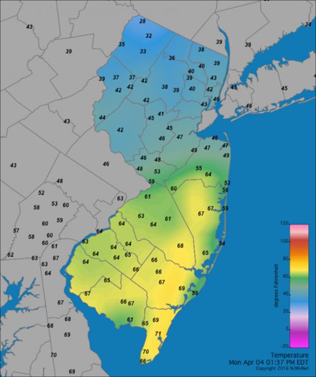
April temperatures fluctuated widely from day to day, from morning to afternoon, and on some occasions at a specific time across the state. An example of the latter is seen in Figure 1.

Figure 1. Temperatures ranged from 28° to 71° across New Jersey at 1:37 PM EDT on April 4, 2016. Rain and snow were falling in the north, while the sun was shining in the south. A modest sea breeze was also in progress along the coast.
The thermometer topped out at 80° or higher at one or more of the 61 NJWxNet stations on six afternoons, at least 75° on nine days, and 70° or above on 14 days. Of those days of 75° or higher maximums, the first came on the 1st when Hamilton (Mercer County) reached 81° and eight other stations were up to 80°. It wasn’t until the 17th that another such day occurred, with Jersey City (Hudson) at 80°. Walpack (Sussex) also reached 80°, following a morning low of 27°, in the process taking daily honors as both the coldest and warmest (tied with Jersey City) location in the state. Wayne (Passaic) reached 85° and Basking Ridge (Somerset) and Hamilton (Mercer) 83° on the 18th, while at the coast Harvey Cedars (Ocean) only got to 64°. Woodbine (Cape May) was 83° on the 19th, with Bivalve (Cumberland) at 82° and Cape May Courthouse (Cape May) 81°. Jersey City reached 78° on the 21st, Toms River (Ocean) 83° on the 22nd (with five stations a 82°), and Jersey City 75° on the 23rd.
Sicklerville (Camden) got up to 78° on the 25th. The 26th was the warmest day of the month, with Sicklerville at 87°, five stations reaching 86°, and 34 stations between 80°–85°. The warm air failed to invade the far north on the 26th, with High Point Monument (Sussex) only getting to 57° and Ramsey (Bergen) 58°.
The temperature fell to 32° or colder at one or more station on 19 April days. Just two days after seeing an 80° reading in the state, High Point Monument fell to 20° on the 3rd. High Point (Sussex) bottomed out at 24° and Walpack 25°. Nine other days fell to at least 25°, continuing on the 4th with the Monument station again down to 20° and High Point to 22°. The 5th was the last day this season when all NJWxNet stations fell below freezing. High Point Monument led the way at 15°, High Point 16°, and Walpack 18°. West Cape May (Cape May) was “mildest” at 31°. The 6th was colder, with the Monument down to 14°, Pequest (Warren) and Berkeley Township (Ocean) at 15°, and nine stations from 16°–19°. Atlantic City Marina (Atlantic) and Harvey Cedars only fell to 33°.
Walpack dropped to 21° on the 9th, with Berkeley Township and Pequest both at 22°. High Point Monument was 20° on the 10th, with all other stations below freezing except West Cape May at 34°. Walpack was 22° on the 13th, Berkeley Township 23° on the 14th, Walpack 24° on the 15th, and Berkeley Township 25° on the 16th. The last April freezing reading in NJ was 28° at Walpack on the 24th.
Precipitation and storms
The wettest locations in the state in April were generally found along the southern coast. Despite this, totals there barely managed to get close to the April norm. Ocean City (Cape May) topped the list of CoCoRaHS stations with 3.94”. This was followed by Lower Township (Cape May) at 3.89”, Wildwood Crest (Cape May) 3.77”, Estell Manor (Atlantic) 3.49”, and Pittsgrove (Salem) 3.32”. On the low end was Edison (Middlesex) at 1.05”, then Franklin Township (Somerset) 1.17”, North Brunswick (Middlesex) 1.19”, Manville (Somerset) and Woodbridge (Middlesex) each at 1.29”, and Cranford (Union) 1.30”.
Snowfall was heaviest in the south and totaled as much as 3.5” in Franklin Township (Gloucester), 3.2” at Ocean City, 3.0” in Linwood (Atlantic), and 2.5” in Woodbine.
Off and on rain with some scattered thunderstorms fell across NJ during the late afternoon and evening of the 1st into the 2nd. Hail was observed in Lebanon (Hunterdon) and Morris Plains (Morris). Rain totaled as much as 1.00” in Ocean City, 0.82” at Long Hill Township (Morris), and 0.81” in both Wildwood Crest and Warren Township (Somerset). There was some wind damage in Raritan (Somerset). A powerful storm system visited the state during the evening of the 2nd into the morning of the 3rd. Severe thunderstorms produced a microburst in Cumberland County, causing considerable damage in Bridgeton and Hopewell. There were reports of pea size hail (with some stones up to 3/8”) in ten counties (other counties likely saw hail too). Lightning started house fires in Bergen County. Cold air moved into the far north and turned rain to snow, with Highland Lakes (Sussex) catching 2.7”, West Milford (Passaic) 2.4”, and Wantage (Sussex) 1.2”. Rainfall reached 0.83” in Estell Manor, 0.79” at Point Pleasant Beach (Ocean), and 0.78” in Lower Township. Additionally, damaging winds howled throughout the state, with ten NJWxNet stations gusting to 50 mph or higher (see wind report below).
Widespread rain was heaviest in the north as it fell during the morning and afternoon of the 4th. Glen Gardner (Hunterdon) and Oxford (Warren) each picked up 0.53”, and River Edge (Bergen) and Harrison (Hudson) saw 0.52”. Daytime rain on the 7th brought southwest and northwest areas about 0.50”, with less than a tenth of an inch along the coast. Mansfield (Warren) received 0.71”, Wantage 0.66”, and Holland Township (Hunterdon) 0.63”.
A clipper system tracked just south of NJ on the 9th, bringing a rather quick shot of rain and snow, mainly to the south. When falling heavily, slushy snow quickly accumulated on natural surfaces and even some roadways. Franklin Township (Gloucester) caught 3.5”, Mullica Hill (Gloucester) and Swedesboro (Gloucester) each 3.0”, Port Norris (Cumberland) 3.0”, Ocean City 3.2”, three Atlantic County stations 2.0”, Somerdale (Camden) 2.0”, Pittsgrove (Salem) 1.5”, and Medford Lakes (Burlington) 1.1”. Rain and melted snow totaled 0.75”–1.00” in much of the far south, tapering to a few tenths of an inch in central areas and less than a tenth in the north. Woodbine stations saw 1.20” and 1.25”, Ocean City 1.08”, and Linwood 0.96”.
A morning squall on the 12th delivered 0.62” to Ocean City, 0.56” at Liberty Township (Warren), and 0.49” to four locations in Warren and Hunterdon counties. Most of the state received 0.10”–0.30”. This was the last precipitation to fall in New Jersey until the evening of the 22nd. During this ten-day dry period, daytime temperatures were often warm, humidity levels low, and winds gusty. Red Flag Warnings were issued at times by the National Weather Service and unfortunately some wildfires occurred. One fire on the 19th in the vicinity of the Northeast Corridor rail line in Secaucus (Hudson) halted service on this critical route for several hours.
Rain returned during the evening of the 22nd into the afternoon of the 23rd. Moderate rain fell from Warren to Bergen counties and in Cape May County, with less elsewhere. Little Falls (Passaic) saw 0.78”, Upper Freehold (Monmouth) 0.75”, and West Caldwell (Essex) 0.69”. Rain fell in the south and north, mostly missing central counties, during the morning and afternoon of the 26th, accompanied by some thunder in the PM hours. Port Republic (Atlantic) saw 0.87”, Little Egg Harbor (Ocean) 0.81”, four Stafford (Ocean) locations 0.80”, 0.80”, 0.71” and 0.71”, and Bloomingdale (Passaic) 0.71”. Light rain during the afternoon and evening of the 29th brought 0.47” to Wildwood Crest and 0.46” to both Sea Isle City (Cape May) and Hamilton (Mercer).
Atmospheric pressure topped out close to 30.50” on the 16th, followed closely by 30.45” readings on the 13th and 15th. The 2nd and 3rd saw the lowest pressures that ran close to 29.30”.
Winds gusted to 40 mph or higher at one or more NJWxNet station on eleven April days. Logan Township (Gloucester) gusted to 54 mph on the 1st, with Wantage up to 40 mph. The 2nd saw Logan Township up to 55 mph, Woodstown (Salem) 47 mph, and Upper Deerfield (Cumberland) 44 mph.
The 3rd brought some of the strongest winds in recent years to the entire state. Wind gusts of at least 50 mph occurred at Sea Girt (Monmouth) 58 mph, Wantage 58 mph, Harvey Cedars 56 mph, Mullica (Atlantic) 55 mph, Cream Ridge (Monmouth) 54 mph, Logan Township 53 mph, West Cape May 52 mph, Oceanport (Monmouth) 51 mph, Point Pleasant (Ocean) 51 mph, and Basking Ridge 50 mph. 29 other NJWxNet stations gusted from 40–49 mph.
Berkeley Township and the new Fortescue station gusted to 47 mph on the 7th, with nine other stations from 40–44 mph. High Point Monument had a 48 mph gust and Wantage got to 40 mph on the 9th. The two stations gusted to 47 mph and 40 mph, respectively, on the 10th. The Monument reached 52 mph on the 12th when Wantage hit 45 mph. The Monument hit 51 mph and Wantage 43 mph on the 19th. The Monument also made it to 43 mph on the 21st and 41 mph on the 23rd. A squall line on the 26th brought gusts of 61 mph to Cream Ridge (Monmouth), 48 mph at Berkeley Township, 48 mph in Harvey Cedars, and 40–43 mph gust at four other stations.


