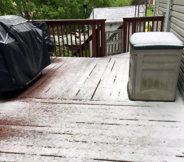
A coating of graupel occurred at some northern NJ locals on May 15, such as this Sparta (Sussex County) residence (photo by Erik Aronson).
May had many weather faces. Cool, damp weeks to start things off, a blustery mid-month day with some frozen precipitation, a week of summer heat, and an early Memorial Day deluge up the New Jersey Turnpike corridor. When all was summed and averaged, the mean monthly statewide temperature came in at 60.0°. This was 0.8° below normal and ranked as the 55th coolest of the past 122 Mays. Precipitation averaged 5.01”, which is 1.01” above average and 23rd wettest.
Precipitation and storms
Rain fell on a number of May days across NJ, keeping vegetation green and fire danger down. It was most plentiful in the southern half of the state, where Mount Laurel Township (Burlington County) totaled 7.74”. This was followed by Mount Ephraim (Camden) with 7.68”, Washington Township (Gloucester) 7.54”, Salem (Salem) 7.41”, Cinnaminson (Burlington) 7.02”, and Estell Manor (Atlantic) and Merchantville (Camden) each with 7.00”. The northwest corner had the least rainfall in May, with just 3.01” in Andover (Sussex) and North Arlington (Bergen), along with Mount Olive (Morris) at 3.04”, Hackettstown (Warren) 3.05”, and Franklin (Sussex) and Wantage (Sussex) each with 3.06”.
The first eight days of May saw five different rain episodes. The totals were not major in any of them, though they provided enough to moisten soils, and cancel many sporting events! From pre-dawn on the 1st through the same period on the 2nd, 0.50”–1.00” fell in the southeast corner of the state with 0.20”–0.50” most everywhere else. Port Republic (Atlantic) and Woodbine (Cape May) each came out on top with 0.99”, followed by 0.95” in Estell Manor. Randolph (Morris) with 0.13” had the least, with only 0.18” in Mount Olive, Tenafly (Bergen), and Kenilworth (Union).
The evening of the 2nd into the morning of the 3rd brought thunderstorms to some central and southern locations. The vast majority of NJ caught 0.50”–1.00”, with more at Lambertville (Hunterdon) 1.20”, Wildwood Crest (Cape May) 1.18”, Bernards (Somerset) 1.17”, and Montague (Sussex) 1.12”. North Arlington had the least with 0.41” and Howell (Monmouth) saw 0.43”. Rain fell from midday on the 4th into the evening. This included some rice to pea-size hail in Ocean City (Cape May) to go with 1.10” of rain. Woodbine had 1.23” at one location, 1.05” in another, with Stafford Township (Ocean) also picking up 1.05”. The rain was concentrated in southeast coastal counties, with little elsewhere. Onshore winds persisted into the 6th, which continued some minor coastal flooding that began on the 4th. The flooding even reached moderate stages in some locations on the 6th. The rain also was renewed, especially in the southwest, from pre-dawn on the 7th to that time on the 8th. Cinnaminson and Salem caught 1.52”, Woodstown (Salem) 1.46”, and Moorestown (Burlington) 1.46”. North Arlington with 0.31” and Wantage at 0.36” saw the least rain. The final shot of rain came on the morning of the 8th, falling mostly in the northern counties. Boonton (Morris) saw 0.42”, with Franklin (Sussex) and Parsippany-Troy Hills (Morris) each receiving 0.39”. Little fell in the southern two thirds of NJ.
The 13th found afternoon rain falling mainly in the northwest. Greenwich (Warren) received 0.52”, Mansfield (Warren) 0.51”, and Roxbury Township (Morris) 0.50”. While precipitation totals were minor, an interesting weather event for mid May occurred on the 15th. Midday and afternoon hours brought brief, windy showers with temperatures in the 40°s. In some northern and central locations, sleet, graupel and/or snowflakes accompanied the squalls. While many considered the frozen precipitation hail, this most likely was not the case anywhere. Rather, the frozen precipitation was quickly brought to the surface when unseasonably cold air aloft descended in showers that developed thanks to the cold air and May sunshine. One of the squalls with sleet occurred in Piscataway (Middlesex) shortly after President Obama delivered the commencement address at Rutgers. Appropriately, the most precipitation on the 15th was the 0.12” in Washington Township (Morris), followed by 0.10” in Washington (Warren). Liberty Township (Warren) had 0.09”, Clinton (Hunterdon) 0.08”, and Jefferson Township (Morris) 0.06”.
Rain arrived during the midday hours of the 21st, moving out of NJ in the pre-dawn hours of the 22nd. Heaviest totals were in the southwest, with Pennsville (Salem) picking up 1.54”, Salem 1.31”, and Mount Laurel 1.24”. Most of the state had 0.30”–0.70” except in the northwest, where Wantage and Montague received just 0.05”. Scattered afternoon thunderstorms on the 23rd transitioned to rain that ended on the morning of the 24th. There were reports of 0.25”–0.50” here and there around the state, with as much as 0.56” in Pittsgrove (Salem), 0.51” in Florham Park (Morris), and 0.50” in Bridgewater (Somerset). Less than 0.10” fell within the Pinelands and northwest. Western Hunterdon and a bit of Warren County received pre-dawn rain on the 27th, with 0.48” in Union Township and 0.30” in Holland Township, both in Hunterdon.
Pockets of heavier rain in Warren County and the northern Highlands in the late afternoon and evening of the 28th brought 0.97” to Denville (Morris), Jefferson Township 0.87”, Rockaway (Morris) 0.79”, and Mansfield (Warren) 0.73”. Locally, the largest rainfall of May fell from the late evening of the 29th into the afternoon of Memorial Day, the 30th. The overnight hours found storms tracking up the general path of the NJ Turnpike, leading to prodigious totals, particularly in Middlesex and Mercer counties where 4.20” accumulated in Cranbury (Middlesex) and 4.02”, 3.96”, and 3.81” in the Mercer communities of Hamilton, East Windsor, and Robbinsville, respectively. Figure 1 shows the distribution of rain through the early morning. Additional rain, exceeding an inch in some locations, fell along the southern coast during the daylight hours. All told, seven CoCoRaHS stations caught more than 3.00”, 13 between 2.00”–2.99”, and 39 from 1.00”–1.99”. The least rain fell near the northern coast, with 0.07” in Pine Beach (Ocean) and 0.17” in Brielle (Monmouth).
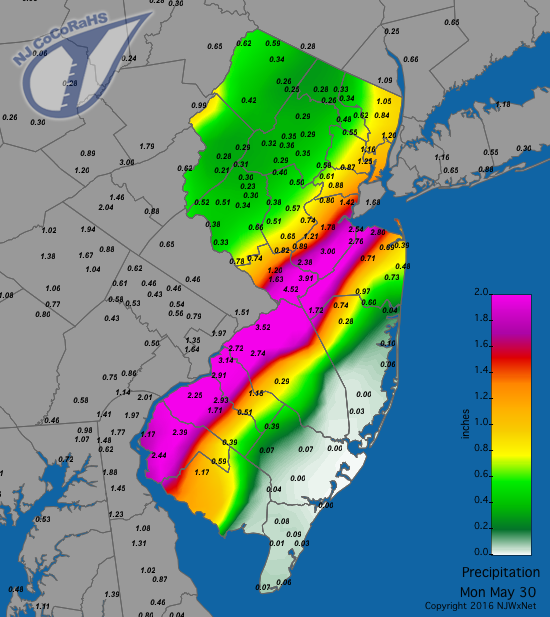
Figure 1. Rainfall from approximately 7 AM EDT on May 29th to 7 AM on the 30th.
The peak atmospheric pressure of the month was close to 30.30” on both the 10th and 20th. The lowest pressure came on the 5th and 8th, with readings between 29.60”–29.65”. Winds guested to 40 mph or higher at one or more NJWxNet stations on five May days. Oswego Lake (Burlington) and Berkeley Township each peaked at 40 mph on the 4th. Oswego Lake and Harvey Cedars (Ocean) each reached 47 mph on the 6th, with Sea Girt (Monmouth) up to 43 mph and Seaside Heights (Ocean) at 40 mph. The 8th was the overall windiest day of the month, with High Point Monument (Sussex) up to 51 mph, Wantage 43 mph, and 25 stations gusting between 30–38 mph. The 15th saw gusts to 46 mph at High Point Monument, 41 mph in Fortescue (Cumberland), and 40 mph at Wantage. The Monument station peaked at 50 mph on the 16th, when Wantage made it to 45 mph.
Temperature
Nine of the first 17 days of May saw minimum temperatures dip below 40° at one or more NJWxNet stations. The High Point (Sussex) and High Point Monument stations fell to 37° and 38°, respectively, on the 1st. Charlotteburg (Passaic) was 37° and the Monument 39° on the 2nd. The 8th found Berkeley Township down to 38° and Pequest (Warren) and Walpack (Sussex) 39°. Berkeley Township and Hopewell Township (Mercer) were 33° on the 9th, Pequest 34°, and 14 stations between 35°–39°. Walpack was 32° and Pequest 36° on the 10th, with these two stations at 34° and 36°, respectively, on the 11th.
The 15th found Walpack down to 34° and High Point Monument 35°. The last freeze of the season and the coldest May morning occurred on the 16th. Walpack dipped to 29°. Hope (Warren), High Point, and High Point Monument all fell to 32°, and 32 of the 60 NJWxNet stations recorded minimums between 33°–39°. Walpack was 36°, Pequest 38°, and Basking Ridge (Somerset) 39° on the 17th.
It took until May 12th for a NJWxNet station to reach 80°, and for a number of locations that mark was not achieved until the 24th. Jersey City (Hudson) got to 84° and Hamilton (Mercer) 83° on the 12th, with 17 other NJWxNet stations between 80°–82°. Jersey City made it to 83° on the 14th, joined by New Brunswick (Middlesex) at 80°. Ten of the last twelve days of the month saw maximums equal or exceed 80°, with half of them 90° or higher. On the 20th, Jersey City and New Brunswick reached 81°. Four stations hit 80° on the 23rd, followed the next day by Stewartsville (Warren) at 84° and Hamilton (Mercer) and Pequest to 83°.
The first 90° temperatures of the year were achieved on the 25th, with five stations topping out at 90°. Every station in the NJWxNet got into the 80°s except the south-facing Delaware Bay coastal stations of Fortescue at 75° and Bivalve (Cumberland) at 78°. Hawthorne (Passaic) reached 93°, three stations 92°, and 18 stations either 90° or 91° on the 26th, with Harvey Cedars only up to 75°. Hamilton (Mercer) and Red Lion (Burlington) hit 92° on the 27th, with just 69° the maximum at Atlantic City Marina (Atlantic). The 28th was the hottest day of the month to start off the Memorial Day weekend. Hawthorne soared to 96°, Haworth (Bergen) and Howell reached 93°, and 21 stations were between 90°–92°. The 29th found Hamilton (Mercer) at 92° and Red Lion 91°. Pequest and Stewartsville got to 85° on the 30th and Hamilton (Mercer) and Mannington (Salem) 89° on the 31st.
Spring 2016
Statewide, March to May temperatures averaged 52.5°, which is 1.5° above normal and ranks as 15th mildest. Precipitation averaged 9.39", which is 2.90" below normal and ranks as 31st driest. Southern locations were the wettest, led by Estell Manor with 13.63”, followed by Mount Laurel 13.39”, Woodbine 12.97” and 12.31”, Ocean City 12.75”, and Wildwood Crest 12.31”. Dryer conditions prevailed in the north, with the lowest total of 5.71” in Cranford (Union), then Hackettstown 6.05”, Bloomingdale (Passaic) 6.30”, Andover 6.34”, and Oakland (Bergen) 6.55”. Snowfall averaged 2.6”, which is 50% of normal. The largest totals were in the coastal south, where Estell Manor caught 8.7”, Berkeley Township 7.4”, Egg Harbor Township (Atlantic) 7.1”, and Woodbine 7.0”.
The southern snow maximum wasn’t what made the season a backwards one, but rather that could be considered an upside down situation (on the heels of a winter where the normally snowiest northwest was least snowy). It was somewhat of a backwards season given the warmth of March, the 6th mildest on record, including the earliest temperatures of 80° or higher in some locations on the 9th. This March’s weather was some of the warmest until the last week of May. Also, there was the frozen precipitation on May 15 that was preceded by the cool, damp first half of the month that, for a time, made many wonder when consistently warm weather would arrive.


