The summertime in New Jersey is characterized by warm temperatures that give some relief from cold and dreary wintertime conditions. However, amongst pleasant summer days, the atmosphere can align in a way that makes the heat on other days rather unbearable — something that we commonly refer to as a heat wave. Heat waves have a large impact on public health, utilities, infrastructure and more, which is why we often hear the media discussing heat waves across the nation. While heat waves may call for a day at the beach, they're also a cause for public concern.
Since the media generalizes heat waves for large geographical areas, we wanted to hone in on New Jersey to see how heat waves are distributed from year to year and whether they have been changing over time. Our first issue was tackling the definition of a heat wave — how do you quantify excessive temperatures for an entire state? The classic definition of a heat wave is simple: when an area equals or exceeds a maximum temperature of 90 degrees for three consecutive days, it is considered a heat wave. While this definition isn't without use, it doesn't paint the entire picture. How do people in Newark fare with three days of 90 degree conditions, compared to people in Atlantic City? Expanding the horizons, can citizens of Duluth, Minnesota, handle 90 degree temperatures like citizens of Tucson, Arizona? There are studies that show that citizens of different climates adjust to weather differently, and therefore the definition of a heat wave should be relative, not general. Before going on, it is important to note that our present study only takes temperature into account. It does not look at humidity levels that we all know when high and combined with elevated temperatures can exacerbate an already potentially dangerous health situation.
For the scope of this article we will be focusing on heat waves in New Brunswick (Middlesex County), however, in the near future, we will be producing more detailed research looking into a network of eight different cities across New Jersey. In order to provide a heat wave definition that is relative to New Brunswick, we looked exclusively at New Brunswick’s temperature records. We redefined a heat wave as three consecutive days being within the top 10% of maximum temperatures for each respective day, which we will hereby refer to as a heat event. So, for example, if June 1, 2014, was within the top 10% of all June firsts on record, we would then look to see if June 2, 2014 was within the top 10% of all June seconds on record, and so forth. We were also able to look into days that were in the top 5% or 1% of observations, along with events that stretched five or more days, in order to find extreme heat events. Since such events can occur anytime throughout late spring to early fall, dates were examined from May through September.
New Brunswick, along with several other New Jersey stations, provides reliable data dating back to 1900 and allows us to look for variability or change over time. So, after isolating the days that met our thresholds, we grouped the events and counted how many times they occurred per year over a 114 year period (1900-2013). Figure 1 shows the number of three or more consecutive day events that were within the top 10% of observations for each day, alongside the classic definition of a heat wave (three or more days with maximum temperatures equal to or exceeding 90 degrees). The two plots are similar, including 278 total events for the classic definition and 242 total events using our definition. Looking at more extreme conditions, Figure 2 shows heat events that were within the top 10%, 5%, and 1% for five or more day events. There is somewhat of a tendency for more heat events in the 1940s-1950s; however, one of the most extreme heat events in New Brunswick on record happened in 2002. This occurred over an eight-day period, from August 13-20. The maximum temperatures during this stretch ranged from 95 to 99 degrees. While not as extreme, there have been other events that reached the top 5% for five or more days, one occurring as recently as 2010.
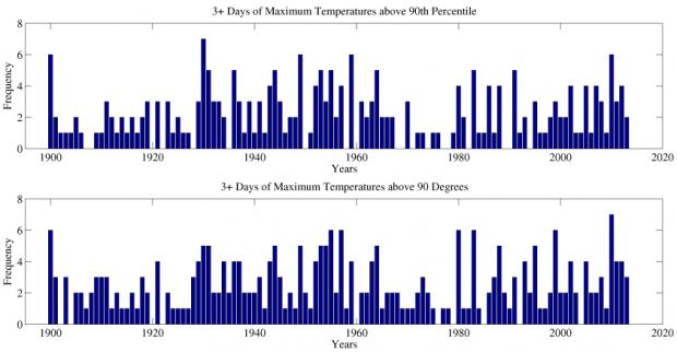
Figure 1. The number of three or more consecutive day events that were within the top 10% of observations for each day (above) and the classic definition of a heat wave (below).
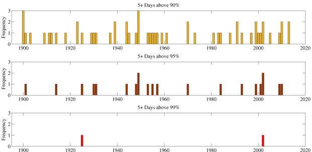
Figure 2. Heat events with daily maximum temperatures that were within the top 10%, 5%, and 1% for five or more day events.
Examining the maximum temperature for each day is worthwhile, but it fails to describe the nighttime conditions since the maximum daily temperature during heat waves always occurs during the daytime. Using the same methodology, we looked at three day or longer events for the top 10%, 5%, and 1% of minimum temperatures for New Brunswick. Consider this the highest minimum temperatures, or if you really want to boggle your mind, the maximum minimums. Figure 3 shows this information in a similar fashion to Figure 2, however here we are only looking at three or greater day events. The most recent 20 years have seen long strings of relatively warm nights, which when combined with the strings of warm days, make for dangerous heat events. There are few evenings that stretch above the 95% percentile for more than 3 days, and only four events that are in the 99% percentile. Comparing this figure to the maximum temperature figures, it is clear that maintaining warm minimum temperatures is more of a rare occurrence than maintaining warm maximum temperatures.
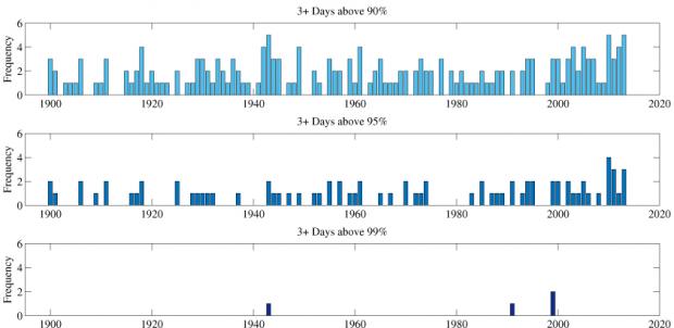
Figure 3. Heat events with daily minimum temperatures that were within the top 10%, 5%, and 1% for three or more day events.
Summing up, observations for more than the past century demonstrate that New Brunswick has long seen extreme heat events, be they associated with torrid daytime maximum temperatures or quite uncomfortably warm nighttime minimums. Daytime heat events appear to be happening more frequently in recent decades, with warm nighttime events becoming even more common than throughout much of the 20th century. The hot temperatures that recently occurred made it into the heat event category — maximum temperatures during the afternoons of August 31 through September 2, 2014, fell within the top 10% each day. Minimum temperatures only reached the top 10% for the first two days of the month. Additionally, the maximum temperature of 94 degrees on Saturday, September 6, was in the top 99% of data for that day. The early September 2014 event is likely to be the last heat event for the year for an otherwise mild summer; however, we should always be prepared to deal with an extreme heat event. Looking forward, we plan to expand this study to other stations, and look not only at temperatures but include humidity observations for a more comprehensive report.


