News

Flooding rains persist

June 19, 2013 - 12:00am -- Dan Manzo

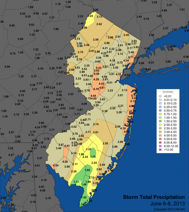
Tropical Storm Andrea rain totals

"It's been a wet one." That's what many New Jersey residents would say so far about the first part of June. There has been little time to dry out in between back to back to back rainstorms.

Earlier this month, only a few days after the official start of the Hurricane Season, Tropical Storm Andrea formed in the Gulf of Mexico and headed northeast bringing heavy rain and gusty winds to parts of Florida and the coasts of North Carolina and Virginia. The remnants of Andrea eventually tracked off our shores and brought a period of very heavy rain to much of the state. Andrea's downpours gave much of the northern Jersey shore around 4.50" to just over 5.00" of rain. Most of the Turnpike corridor saw precipitation range from 3.50" to a little over 4.00". There was less precipitation to the southeast and the northwest with those areas averaging around 2.00"-3.00".

A manageable heat wave to end May

June 4, 2013 - 12:00am -- Dan Manzo

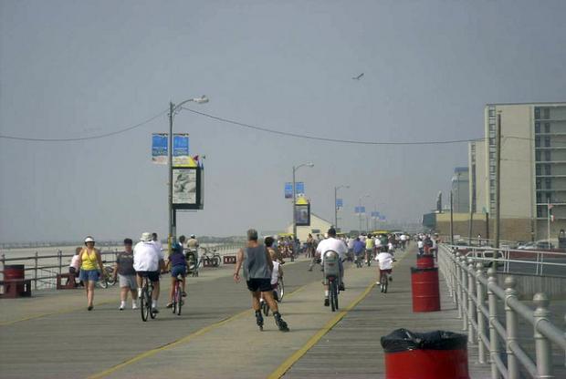
Boardwalk photo

A week after the unofficial start of summer many areas saw temperatures soar, giving the Garden State its first heat wave of the season (a heat wave is defined as a hot period having at least three consecutive days of 90°+ temperatures). Temperatures steadily rose throughout the period from May 29 to May 31, with most areas away from the shoreline getting into the low to mid 90’s.

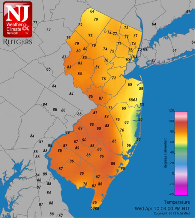
Just prior to the beginning of the heat wave on May 29, temperatures along the state’s Turnpike corridor rose into the upper 80’s. Our NJWxNet Woodstown station in Salem County recorded a high temperature of 88°, Cream Ridge in western Monmouth County recorded a maximum of 87°, and Haworth in Bergen County recorded a high of 86°. The story was not the same away from the urban corridor. Wantage (Sussex County) only made it to 80°, and Atlantic City Marina topped off at 71°.

May 2013 Summary and Spring Recap

June 2, 2013 - 12:00am -- Dave Robinson

Seaside Heights boardwalk rebuild

If there is one thing that was consistent with New Jersey's weather in May, and for that matter throughout this past spring (March-May), it was the inconsistency. Of course this is rather typical of many a spring month, as our region sits in the battle zone between reluctantly retreating winter conditions and sporadically advancing summer weather. When all was said and done, May 2013 came in with a near average statewide temperature of 60.7°. This was 0.1° below the 1981-2010 average and ranks as the 53rd mildest May of the past 119 years (1895-present). Precipitation averaged 4.01", a minute 0.01" above average and was the 42nd wettest on record. It was not only day-to-day conditions that varied in May, there were also notable differences in temperature and precipitation from one location to another.

April 2013 Summary and 2012-2013 Snow Season Recap

May 4, 2013 - 12:00am -- Dave Robinson

April sea breeze map

While many wondered if spring would ever arrive across the Garden State, the average April temperature was actually close to the long-term mean. At 51.5°, the month was 0.3° above average, ranking as the 35th mildest April since statewide records were established in 1895. Using the central NJ city of New Brunswick as an example, 16 days were above average, 12 below, and two spot on average.

A Chilly Start to Spring: March 2013

April 7, 2013 - 12:00am -- Dave Robinson

While the core of the winter season (December-February) averaged quite a bit milder than usual across New Jersey (see winter summary in the February narrative), the broader cool season began with a November that was cooler than average with above-average snowfall and ended with a cooler and snowier than average March, making for what seemed to be a long winter. Looking more closely at March 2013, the statewide average of 38.3° was 2.8° below the 1981-2010 average and ranked as the 37th coolest since 1895. What a difference a year makes, as March 2012 was 11.5° warmer than this year! Precipitation (rain and melted snowfall) averaged 3.05", which is 1.18" below average and the 36th driest on record. Snowfall averaged 5.2", which is 1.0" above average.

Chilly conditions were rather consistent during March, with only six days where one or more observing stations in NJ reached a maximum of 60° or higher. There was an absence of excessive cold, with lows falling into the teens in some locations on 12 mornings, yet most of the state dropping no lower than the 20°s at any point. Beginning with the cold lows, the 3rd and 4th both dawned with the NJWxNet High Point and High Point Monument stations (Sussex County) at 18° and 19°, respectively. Walpack (Sussex) was coldest at 19° on the 9th. The 10th was one of the three coldest mornings statewide in March. Pequest (Warren), Berkeley Township (Ocean), and Walpack fell to 19°, with a total of 23 of the 55 stations in the NJWxNet at 25° or colder.

A Rather Average Month, A Mild Winter 2012/2013

March 15, 2013 - 3:59pm -- Dave Robinson

Snow cover photo

An amalgamation of cold and mild spells, a few moderate rain events, one significant snowstorm, and several local or minor snowfalls brought a rather average February in the weather department to New Jersey. Preliminary numbers indicate an average temperature of 32.5°. This is 1.3° below normal and 53rd warmest of the 119 Februaries since 1895. Precipitation averaged 3.28" (rain and melted snow/sleet), which is 0.42" above normal and 44th wettest. Snowfall averaged 6.8", which is 1.2" below normal and 53rd most snowy.

A Mild Start to the Year, Despite One Frigid Week: January 2013 Report

February 13, 2013 - 4:16pm -- Dave Robinson

Highway sign knocked over by the wind

By mid-winter standards, January 2013 was not an exceedingly memorable one in the New Jersey weather and climate annals. But like every month, there were certainly events worthy of mention. This included the state's coldest week since 2007 and a surge of warmth late in the month that was broken by a squall line with strong winds and heavy rain.

Statewide, the January temperature averaged 33.7°, which is 2.5° above average. This ranks as the 27th mildest January since 1895 (119 years). Of the past 24 months, only one (November 2012) has averaged below normal. Going back a bit further, since March 2010, 30 of the past 35 months have been above average, one month was exactly average, and four months were below average.

The first three weeks of the month were mostly on the mild side. On five of the first 20 days, one or more station topped out at 55° or higher.

Sandy Strikes: October 2012 Report

November 9, 2012 - 3:47pm -- Dave Robinson

Hurricane Sandy satellite image

Sandy, a category 1 hurricane as it approached the New Jersey coast during the daytime hours of the 29th and a post-tropical cyclone as it came ashore near Atlantic City (Atlantic County) that evening, dealt the state a punishing blow. It brought hurricane-force wind gusts to coastal and inland sections, close to a foot of rain in the far south, a state record low barometric pressure, and a record storm surge along the coast and in adjacent water bodies. Additional
information on Sandy can be found later in this report, and a more complete analysis will be provided on an upcoming website from the state climate office.

Statewide, the month averaged 57.1°, which is 2.3° above average. This ranks as the 20th warmest October since statewide records commenced in 1895. It marks the 21st consecutive month with temperatures equal to (June 2012) or warmer than (all other months since February 2011) average. The first ten months of this year have averaged 58.9°, or 3.1° above the 1981-2010 average. This keeps 2012 on pace to be the Garden State's warmest year on record (Table 1).

Pages

Subscribe to RSS - News