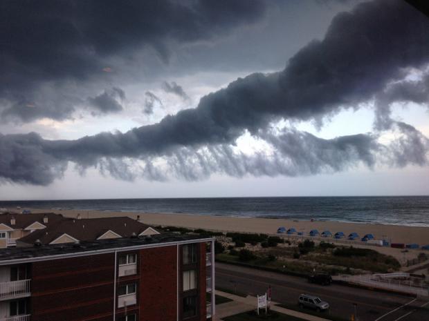
Roll cloud ahead of squall line in Cape May on the evening of June 23rd, where climatologists from 40 states were gathered for the 40th Annual Meeting of the American Association of State Climatologists. Photo by Missy Holzer.
Overview
Toward the end of May, the threat of a significant drought loomed over the Garden State, as May proved to be the 3rd driest on record. Crops were in bad shape or not growing at all, and reservoir levels were declining at a faster than seasonal rate. However, New Jersey had yet to reach the point where average and timely rainfall could not remedy the situation. Not only was this prescription filled, it was done in abundance. June rainfall averaged 8.21" across NJ. This was 4.19" above the 1981-2010 normal and ranked 4th wettest since 1895 (Table 1). It joined four other Junes in the past 13 years to rank in the top eight over this 121-year period. As explained in last month's report, the rains that fell during the daytime and evening hours of May 31st factored into the June total, much as the localized afternoon and evening rains on June 30th (discussed below) will count toward the July total.
| Rank | Year | June Avg. Precip. |
|---|---|---|
| 1 | 2013 | 9.58" |
| 2 | 2003 | 8.61" |
| 3 | 1972 | 8.41" |
| 4 | 2015 | 8.21" |
| 5 | 1938 | 7.73" |
| 6 | 1903 | 7.52" |
| 7 | 2006 | 7.42" |
| 8 | 2009 | 6.79" |
| 9 | 1928 | 6.61" |
| 10 | 1902 | 6.43" |
Table 1. Top 10 wettest NJ Junes since 1895.
The statewide average June temperature of 70.6° was 0.5° above the 1981–2010 normal. This ranked as the 30th warmest June since 1895. On eight afternoons a weather station observed a temperature between 90°–95°, with the 11th–16th the warmest interval.
Precipitation and storms
It did not take long for rain to resume following the May 31st/early June 1st deluge. Later on the 1st through the early hours of the 3rd a statewide soaking exceeded 1.00" at 142 of the 219 reporting CoCoRaHS stations. The heaviest rain fell in the southern third of the state. Fairfield Township (Cumberland County) caught 4.83", Pittsgrove (Salem) 4.68", and Buena Vista (Atlantic) 4.51". Elsewhere, there was a localized heavy total in the Bridgewater Township (Somerset) 2.44" and Somerville (Somerset) 2.47" area.
Ten more episodes where at least an inch was deposited somewhere in NJ followed in June. Next up were morning storms on the 5th that were heaviest in the southwest (Pennsville [Salem] 1.25") and Morris County (Randolph 1.46" and 1.58"; Mendham 1.01"). Thunderstorms during the morning and afternoon of the 6th brought heavy rain to southern and central Cape May County, but little to none elsewhere in NJ. Wildwood Crest saw 2.18", Middle Township 2.00", and North Wildwood 1.70". An evening squall line on the 8th hit the southwest with close to 2" of rain and totals of an inch running up the Delaware Valley to northwest NJ. Coastal areas did not see much rain. Clayton (Gloucester) received 2.10", Winslow Township (Cumberland) 1.93", and Monroe Township (Gloucester) 1.90". While at most only 0.51" of rain fell at Mendham on the evening of the 12th, a fast hitting storm brought down some trees and power lines in Sussex and Warren counties.
Evening storms on the 14th deposited heavy rain across north central NJ from Warren and Hunterdon east to Hudson and Union. Two stations in Flemington (Hunterdon) received 1.81" and 1.75", while three in Hillsborough (Somerset) picked up 1.68", 1.54", and 1.31". Some 61 CoCoRaHS stations had between 1.00"–1.81". The next afternoon and evening, storms deposited pockets of heavy rain in the northeast, northwest, and northern coast. Among the heftier totals were Little Falls (Passaic) 2.36", Kenilworth (Union) 1.70", Cranford (Union) 1.56", Kearny (Hudson) 1.44", and Florham Park (Morris) 1.44". Continuing the showery streak, the afternoon of the 16th brought storms to the Atlantic/Cumberland and Bergen regions. Estell Manor (Atlantic) received 1.10" and there was some damage to trees and wires in the area. Glen Rock (Bergen) caught 0.89". Off and on light to moderate rain followed from the evening of the 17th through the pre-dawn hours of the 19th in the southern third of the state. Pennsville picked up 1.08", while little to no rain fell to the north.
The remnants of Tropical Storm Bill, which days earlier made landfall along the Texas coast, provided some pockets of soaking rain to NJ from the evening of the 20th into the morning of the 21st, followed by some afternoon rain in the north. All told, Linwood (Atlantic) caught 2.33", Ocean City (Cape May) 2.15", Liberty Township (Warren) 1.81", and 31 other stations between 1.00" and 1.81". Elsewhere, only 0.25"–0.50" fell, despite forecasts of more widespread downpours. This storm track was a common one during June, as parcels of moisture rotated clockwise around the periphery of a high-pressure system that was situated over the Southeast US. This differed from May, when high pressure commonly parked over the Mid Atlantic, with its subsiding air inhibiting rainfall.
The merry go round of moisture continued on the 23rd, when one of the hottest days of June helped to spawn a severe squall line. This blasted through a swath of southern NJ from Camden to Long Beach Island during the early evening. Straight-line winds and likely several microbursts (a concentrated area of very strong straight line winds) resulted in numerous trees, branches, wires, and fences being blown down. NJWxNet stations reported gusts of 71 mph at Hammonton (Atlantic), Mullica (Atlantic) 69 mph, Harvey Cedars (Ocean) 68 mph, Oswego Lake (Burlington) 65 mph, Sewell (Gloucester) 53 mph, and Upper Deerfield 50 mph. Six other stations gusted in the 40–49 mph range and seven between 30–39 mph. Downburst winds likely exceeded 80 mph in some areas. The storm resulted in several hundred thousand customers losing power, mostly in the southern part of the state, and communication networks were out for an extended period. This was the worst south Jersey damage since the June 29–30, 2012, derecho and largest power outage in NJ since Sandy in October 2012. Fortunately, there were no deaths attributed to this storm. Rainfall was a secondary part of this event but still totaled up to 2.21" in Blairstown (Warren), 2.20" in Upper Deerfield, and 1.25" in Dennis Township (Cape May). Only the southern third and northwest corner of the state received more than 0.50".
The southeast had a bout of rain from the evening of the 25th into the morning of the 26th. Estell Manor picked up 1.19", Middle Township 1.08", and Cape May (Cape May) 1.05". The southwest had about 0.25", with little to no rain elsewhere. The morning of the 27th into the morning of the 28th brought a period of damp, dreary, and cool conditions throughout the state. Heavy rain invaded NJ later on the 27th, resulting in some flash flooding of roads and streams in a zone not too dissimilar from that impacted by the strongest winds on the 23rd. Three inch plus rains fell near the Monmouth/Ocean border and in an area encompassing eastern Camden and Gloucester and western Atlantic counties. At least two inches fell in most of the remainder of southern NJ, with 1–2" further north. The greatest totals, all in Ocean County, included Brick Township with reports of 4.72", 3.62", 3.61" and 3.56", Little Egg Harbor 3.73", Pine Beach 3.70", and Toms River (Ocean) 3.68". Some 45 CoCoRaHS stations received from 2.00"–4.72", 140 caught from 1.00"–1.99", and only 10 had less, ranging from 0.74" in Denville (Morris) to 0.99" in Bloomingdale (Passaic).
A locally severe thunderstorm, with a likely microburst, hit the Hackettstown area of Warren County on the afternoon of the 30th. Hail about 0.25" in diameter fell and numerous trees and wires went down, resulting in power outages. A small area of heavy rain totaled as much as 1.74" in Mansfield Township and 1.71" at Pequest. Later that evening, heavy rain resulted in some flash flooding in western Sussex County, where 2.45" fell at Montague.
When all was said and done, 12 CoCoRaHS stations picked up over 10" of rain in June. Taking top honors was Pittsgrove with 12.66", followed by two Upper Deerfield sites at 11.96" and 11.04", Buena Vista 11.90", Pennsville 11.82", Franklin Township (Gloucester) 11.51", and Liberty Township 11.01". Even this month's drier central region had above-normal rainfall. This includes Hamilton (Mercer) 5.04", Robbinsville (Mercer) 5.30", Franklin Township (Somerset) 5.41", Princeton (Mercer) 5.49", Lawrence (Mercer) 5.60" and 5.56", and Burlington (Burlington) 5.63".
In addition to the storm on the 23rd, winds gusted over 40 mph at NJWxNet stations on three other June days. Oswego Lake reached 42 mph on the 1st, Wantage (Sussex) 42 mph on the 21st, and on the 27th Harvey Cedars reached 45 mph, Seaside Heights (Ocean) 44 mph, and Sea Girt (Monmouth) 44 mph. The highest barometric pressure of the month was close to 30.30" on the 4th, with the lowest between 29.60"–29.65" on the 28th.
Temperature
Eight June afternoons saw temperatures peak at 90° or higher at one or more of the 55 NJWxNet stations. Before starting a listing of these days and temperatures, it is worth reporting that on June 1st the highest reading in NJ was 86° at Greenwich (Cumberland) while the thermometer only made it up to 51° at the High Point and High Point Monument stations in far northern Sussex County.
The first June day to 90°, the 11th, saw Berkeley Township (Ocean) and Hamilton (Mercer) top out at 93°, with 30 other NJWxNet stations at 90°–92°. Harvey Cedars was coolest at 78°. The 12th was close behind, with Hamilton and South Harrison (Gloucester) at 94° and 27 stations between 90°–93°. Woodbine (Cape May) reached 90° on the 13th. South Harrison was 91° and Cherry Hill (Camden) 90° on the 14th. Hamilton reached 91° and West Creek (Ocean) 90° on the 15th. Cape May Courthouse (Cape May) maxed out at 92° on the 16th, with 11 stations at 90° or 91°.
About a week later, Oswego Lake reached 91° and three stations 90° on the 22nd. Leading up to the severe evening storms, the 23rd brought a 95° maximum to Oswego Lake, eight stations reached 94°, and 22 were between 90°–93°.
Minimum temperatures in the upper 30°s and 40°s occurred somewhere in the state on 10 June days. The 1st saw High Point Monument and High Point down to 45°, with four other stations in the upper 40°s. High Point fell to 41° on the 2nd, the Monument to 42°, and Wantage to 45°, with 23 stations in the upper 40°s. High Point Monument and Wantage were 46° on the 3rd, with the two High Point stations at 46° or 47° on the 4th and the Monument at 49° on the 5th. Walpack (Sussex) fell to 44° on the 6th, with Basking Ridge (Somerset) and Pequest at 47°.
The final 30°s of the season occurred on the 7th when Walpack chilled to 38° and Pequest to 39°. At 41°, Basking Ridge led 22 stations in the 40°s. Pequest was 49° on the 10th. It was two weeks before 40°s returned, with Walpack at 49° and Pequest 49° on the 25th, and both High Point stations at 49° on the 27th.


