News

A Fitting Finale: December 2018 Recap and Annual Summary, including the Top 10 Events of 2018

January 7, 2019 - 1:58pm -- Dave Robinson

Rainy street

It is appropriate that the weather of last month of 2018 was rather similar to many earlier months in the year. Statewide, precipitation was above average for the 10th month of 2018 and the temperature was above average for the 8th month. This resulted in the year being the wettest on record and the 11th warmest since statewide observations began being calculated in 1895.

December precipitation totaled 5.38”. This is 1.53” above the 1981–2010 average and ranks as the 20th wettest (tied with 2007). Snowfall averaged 1.0”, which is 3.9” below average and the 31st least snowy December since 1895. The only notable snowfall was across a swath of south Jersey on the 5th, leading to a south Jersey monthly average of 1.7”. This is 1.9” below average and ranks as the 55th least snowy December. Northern counties averaged 0.6” for the month, some 6.0” below average and ranking 19th least snowy. Central counties came in without any measurable snowfall. This is 5.5” below average and joins ten other Decembers of the past 124 years without measurable snow, four of which have been this century (2001, 2006, 2011, and 2015).

The average statewide temperature was 37.5°. This is 2.3° above the 1981–2010 average and ranks as the 18th mildest December of the past 124 years (tied with 1972 and 1991).

Winter Arrives Early, Record Wet Fall: November 2018 and Fall 2018 Recaps

December 5, 2018 - 5:11pm -- Dave Robinson

Snow-covered highway

November weather packed quite a punch, putting an exclamation point on what will go into the book as the wettest Fall (September–November) on record (since 1895). With seven storms that each deposited an inch or more of rain (or melted snow) at numerous locations, this was the second wettest November. The statewide average of 8.77” was 5.16” above the 1981–2010 average. The record will remain 9.01” in 1972.

One of the largest early-season snowstorms on record delivered significant impacts to all but southeastern NJ on the 15th. This event alone resulted one of the snowiest Novembers on record. Statewide, the monthly snowfall was 4.1”, which is 3.3” above average and ranks as the 6th snowiest since 1895 and the snowiest since 1989. With 7.4” in the north (Sussex, Passaic, Bergen, Warren, Morris, Essex, and Hudson counties), it was the snowiest November since 1938 and 3rd most on record. Central NJ (Hunterdon, Somerset, Union, Middlesex, Mercer, and Monmouth counties) received 4.8” (+3.9”), the 5th snowiest on record and most since 2012. The south (Burlington, Ocean, Camden, Gloucester, Atlantic, Salem, Cumberland, and Cape May counties) averaged 2.0” (+1.4”), the 10th snowiest and most since 2012.

Growing Season Is Over for the Entire State

November 12, 2018 - 12:40pm -- Dave Robinson

Frost photo

With today’s (11/12) minimum temperature at West Cape May (Cape May County) and Lower Alloways Creek Township (Salem) falling to 30° and 32°, respectively, the growing season has ended across the Garden State. The growing season is considered to be the count of days between the last freeze of the spring and the first freeze of the fall (counting neither of those freezing days). This made for a 214 day growing season at West Cape May, while the Lower Alloways Creek Township weather station was just installed in July, thus a seasonal number is unavailable. These first freezes were preceded by a day at the Atlantic City Mariana (Atlantic) and Harvey Cedars (Ocean), which fell to 32° and 31°, respectively, on the 11th. Based on observations from these Rutgers NJ Weather Network stations (the 62 stations upon which the growing season is determined), these two locations had NJ’s longest growing seasons. The Marina saw its last spring freeze on March 22nd, giving it a 233 day season. Harvey Cedars last froze on April 2nd, thus ended with a 222 day season.

Rapid Transition: October 2018 Recap

November 5, 2018 - 7:37pm -- Dave Robinson

Coastal flood photo

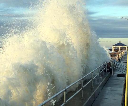
October was a tale of two half-months. Summer-like weather prevailed through the 11th, quickly transitioning to fall-like conditions on the 12th. Passage of the first strong cold front of the season was responsible for the change. Moderate to heavy rain accompanied the front in northwest NJ during the daytime hours of the 11th. That evening, and into the morning of the 12th, moisture from the remnants of once major Hurricane Michael ran up against the front and brought heavy rain to south Jersey. This one-two punch was followed on the 17th by the first freezing temperatures of the season at a few locations and a more widespread freeze on the 19th. Generally cool conditions prevailed the remainder of the month. The remnants of yet another major hurricane, Willa, provided energy and moisture to a quick-hitting nor’easter on the morning of the 27th that brought some of the worst coastal flooding since Sandy in 2012. Michael was an Atlantic storm that made landfall in the Florida panhandle, while Willa was an eastern Pacific storm that came ashore on the west coast of Mexico.

First Widespread Freeze of the Season

October 19, 2018 - 10:51am -- Dave Robinson

Oct 19 minimum temperature map

This morning was a frosty one, with many NJWxNet locations across the state seeing their first freezing temperatures of the season. The accompanying map shows that most every location away from coastal and urban environs dipped to the freezing point or lower. Walpack (Sussex County), the traditional cold spot in NJ on calm clear nights, was the coldest spot at 24°. Atlantic City Marina (Atlantic) and Lower Alloways Creek, along the Delaware Bay coast in Salem County, were mildest, with lows of 46°. All other NJWxNet sites were no milder than 42°. One of the more interesting cold readings was the 32° minimum at Jersey City (Hudson). This station is located in Liberty State Park, demonstrating that even parkland within urban regions can get awfully chilly on calm, clear nights. However, it is a bit surprising to see this low, given that the station is quite close to the waters of NY Harbor.

Once Again, Summer is Slow to Depart: September 2018 Recap

October 7, 2018 - 8:18pm -- Dave Robinson

Coastal flood photo

For the fourth consecutive year, summer weather stubbornly hung on well into September across the Garden State. The statewide average temperature of 70.4° was 4.6° above the 1981–2010 mean, and ranks as the third warmest since records commenced in 1895. September 2017, now ranking 11th, sat in the top 10 for just one year before being bumped out by 2018. This September was the fifth consecutive month of above-average temperatures. The past 12 months have seen the 2nd warmest October, 4th warmest May, 1st warmest August (tied with 2016 based on updated figures), and now the 3rd warmest September. The June through September period this year averaged 73.3° (+2.5°), making it the 4th warmest on record. The top 10 such intervals have all occurred since 2005. The August–September average of 73.7° (+4.3°) was the warmest on record, followed by 2005, 2016, 2015, and 2010.

Perhaps what was most interesting about temperatures this past month was the disparity between average maximum and minimum temperature anomalies. The average maximum of 77.7° was 1.4° above average and ranked 27th warmest. However, the average minimum of 63.2° was 7.9° above average and is a whopping 2.2° milder than the previous highest September average minimum. This came about due to the excessive cloud cover and humidity throughout most of the month, which kept the days from getting too warm and, come nighttime, “trapped” much of the heat gained during the day within the lower atmosphere. Thus, unlike the past three warm Septembers (as well as 2013 and 2014), each of which had below-average precipitation, this year was anything but dry. There were frequent rainy episodes, which at times produced localized deluges and resultant flash flooding. The statewide average rainfall of 7.60” is 3.55” above the 1981–2010 average, and is tied with 1960 as the sixth wettest September since 1895. The wettest September on record remains 1999, which averaged 9.50 inches, in no small part due to Tropical Storm Floyd’s rains. Aside from 1999, you have to go back to 1975 to find a September with more rain than this year.

Green Warmth: August and Summer 2018 Recaps

September 5, 2018 - 8:18pm -- Dave Robinson

Flash flood photo

The summer of 2018 concluded on a warm, wet note across the majority of what was a persistently green Garden State throughout the season. The warmth dated back to late June, with frequent humid conditions and abundant showers from mid-July onward. There will be more on the entire summer at the end of this report. First a look at August, with a statewide average temperature of 76.8° coming in 3.8° above the 1981–2010 average. This was the second warmest August since 1895, falling just behind 2016 by 0.1°. Nine of the 13 warmest Augusts during that 124-year interval have occurred since 2001.

Statewide, August precipitation averaged 5.63”. This was 1.53” above the 1981–2010 average and ranked as the 32nd wettest since 1895. It was the wettest August since the record wettest month in 2011. As is often seen in the summer, the majority of the precipitation fell in scattered showers and thunderstorms. This resulted in a wide range of monthly totals around the state, with some serious flash flooding occurring in several locations when moisture-ladened storms parked themselves over an area for multiple hours. Where storms missed time and time again, rainfall totals were below average. The northern NJ climate division (Hunterdon, Somerset, and Union counties northward) saw their 10th wettest August on record, with an average of 8.28” falling. This is 4.17” above average. Since 1990, only August 2011 was wetter in this division.

Summer Personified: July 2018 Recap

August 3, 2018 - 11:45pm -- Dave Robinson

Flash flood photo

July 2018 had a classic variety of summer weather. There was: 1) an ongoing heatwave to begin the month; 2) dry conditions for the most part in the first half of the month; 3) some warm, exceedingly humid conditions with widespread, at times heavy, showers the second half of the month (courtesy of the subtropics); and 4) some “top 10” sunny dry days following several cold front passages (thank you Canada).

The average statewide July temperature was 76.4°. This is 1.8° above the 1981–2010 average and ranks as the 13th warmest July in 124 years of records (2.6° above the full period of record average). Eleven of the 18 warmest Julys since 1895 have occurred in the past 20 years (since 1999). The average daily maximum temperature across the state was 87.2°, which is 2.2° above average and ranks as the 15th warmest on record. The 65.6° average minimum was 1.4° above the 1981–2010 average and comes in as the 17th warmest.

Statewide, August precipitation averaged 5.63”. This was 1.53” above the 1981–2010 average and ranked as the 32nd wettest since 1895. It was the wettest August since the record wettest month in 2011. As is often seen in the summer, the majority of the precipitation fell in scattered showers and thunderstorms. This resulted in a wide range of monthly totals around the state, with some serious flash flooding occurring in several locations when moisture ladened storms parked themselves over an area for multiple hours. Where storms missed time and time again, rainfall totals were below average. The northern NJ climate division (Hunterdon, Somerset, and Union counties northward) saw their 10th wettest August on record, with an average of 8.28” falling. This is 4.17” above average. Since 1990, only August 2011 was wetter in this division.

Rather Typical: June 2018 Recap

July 5, 2018 - 4:08pm -- Dave Robinson

Sandy Hook from plane

After an ample share of ups and downs throughout the past spring, the weather in June became rather typical for the start of summer. It was drier than average in the north and wetter than usual in the south, with the temperature close to the long-term mean. Fortunately, New Jersey entered the heart of summer with reservoirs full. However, with the onset of an apparent extended period of heat late in the month, it is certainly prudent to conserve water wisely.

The June average statewide temperature of 69.8° equaled the 1981–2010 mean, but is 1.0° above the 1895–present average. This tied with 1906 and 1967 as the 42nd mildest June on record. Precipitation averaged 3.43” across NJ, which is 0.58” below the 1981–2010 mean. This ranks as the 57th driest June, tied with 2011.

Warm and Wet May, and an Action Packed Spring: May 2018 Summary and Spring Recap

June 5, 2018 - 5:16pm -- Dave Robinson

Tree on house

After April timidly transitioned into milder weather, May was plenty bold in the thermal department, on multiple occasions behaving more like summer than late spring. Most NJ residents did not seem to mind the warmth; rather, from the second week onward, it was the frequent episodes of rain, often targeting weekends, which raised the level of crankiness among many! Statewide, this was the 5th warmest May since records commenced in 1895. The 65.0° average was 4.5° above the 1981–2010 mean. Five of the ten warmest Mays have occurred since 2004. In most locations, rain fell on at least half of the days of the month. The 5.96” average across NJ was 1.97” above the 1981–2010 mean. This ranks as the 13th wettest May on record, but 0.55” below last year’s average.

Pages

Subscribe to RSS - News