Overview
The moist and mild pattern of late spring and early summer has left the Garden State quite green. There is nothing new to this pattern, as the first six months of 2019 totaled 27.22” of rain and melted snowfall, some 4.92” above the 1981–2010 mean, and a 49.0° average temperature, which is 1.3° above average. Each of these ranks 13th highest of the past 125 years.
Even more impressive, the past 12 months have seen 10 wetter than average and 10 warmer than average. The two drier-than-average months (March and April) were closer to their 30-year mean than any of the wetter ones. The precipitation total for the past 12 months is 65.28”. This is the second wettest 12-month period on record out of all 1483 12-month periods dating back to 1895. The wettest was 66.62” for the period ending this past January. As seen in Table 1, the majority of the top 20 such periods have occurred this decade. They have included the two wettest calendar years on record (2018 and 2011) and appear to have lasted longer than earlier wet intervals. Meanwhile, the warmth of the past 12 months (54.5°) would rank as the 9th warmest calendar year but not within the top 20 for any 12-month period.
| Rank | 12-month period | End Year | Precip. |
|---|---|---|---|
| 1 | Feb–Jan | 2019 | 66.62" |
| 2 | Jul–Jun | 2019 | 65.28" |
| 3 | Jan–Dec | 2018 | 64.77" |
| 4 | Jan–Dec | 2011 | 63.95" |
| 5 | Mar–Feb | 2019 | 63.85" |
| 6 | Jun–May | 2019 | 63.67" |
| 7 | Apr–Mar | 2010 | 63.49" |
| 8 | Feb–Jan | 2012 | 63.40" |
| 9 | Apr–Mar | 2019 | 63.05" |
| 10 | Dec–Nov | 2011 | 63.01" |
| 11 | May–Apr | 2019 | 62.83" |
| 12 | Oct–Sep | 2011 | 62.54" |
| 13 | Mar–Feb | 2012 | 61.66" |
| 14 | May–Apr | 2010 | 61.60" |
| 15 | May–Apr | 1939 | 61.37" |
| 16 | Nov–Oct | 2011 | 61.35" |
| 17 | Aug–Jul | 1984 | 61.17" |
| 18 | Jul–Jun | 1972 | 60.96" |
| 19 | Oct–Sep | 1952 | 60.66" |
| 20 | Aug–Jul | 1972 | 60.64" |
Table 1. New Jersey’s 20 wettest 12-month periods since 1895.
This past June’s precipitation averaged 4.91” across NJ. This was 0.90” above the 1981–2010 average and ranks as the 28th wettest since 1895. The northern portion of the state was wettest at 5.19”, with the south coming in with 4.79”. However, the northern anomaly of +0.74” (ranking 28th) was smaller than the south’s 1.02” departure (ranking 29th). A warm end to the month raised the statewide average to 70.6°. This was 0.8° above average and ranks 27th mildest of the past 125 Junes. Less frequent cloud cover in the south than up north resulted in a mean of 71.9°, which was 1.0° above average and ranks 19th mildest. The northern temperature of 68.6° was 0.5° above average and ranks 32nd mildest.
Precipitation and Storms
There was a 9.94” difference between the wettest and driest observing station in the state in June. This was in large part due to extremely heavy rains in the west central area on the 19th–20th, while far southern and portions of northern NJ missed out on many of the showers throughout the month. The top June total was 12.70” in Tabernacle (Burlington County). This was followed by Medford Lakes (Burlington) 10.45”, Columbus (Burlington) 9.96”, Cherry Hill (Camden) 9.71”, West Deptford (Gloucester) 9.56”, Medford Township (Burlington) 9.05”, and Burlington (Burlington) 9.03”. On the dry side of the ledger, two Woodbine (Cape May) stations came in with 2.76” and 3.42”, two Middle Township (Cape May) locations at 2.89” and 3.33”, Egg Harbor Township (Atlantic) 2.89”, Dennis Township (Cape May) 2.96”, Fortescue (Cumberland) 3.14”, Cape May Courthouse (Cape May) 3.36”, and Sandyston (Sussex) 3.37”.
It did not take long for the first drops of rain to fall in June. Evening thunderstorms on the 2nd brought 0.95” to Folsom (Atlantic County), 0.91” to Washington Township (Gloucester), and 0.89” at Linden (Union). Pea-size hail fell in Franklin Township (Gloucester). In a preview of a larger event later in the month, the Burlington County area saw the most rain in an episode from the evening of the 5th into the morning of the 6th. Hainesport received 1.47”, Mount Laurel 1.30”, Burlington 1.07”, and Medford Township 1.07”. Plainsboro (Middlesex) also caught 1.07”. Late showers in the south on the 9th that lasted into the predawn of the 10th brought light rain to south Jersey. It totaled as much as 0.46” and 0.38” in Pennsville (Salem), but most importantly, helped to extinguish an 1,800 acre forest fire in Wharton State Park near the Burlington-Camden county line.
Rain resumed later in the day on the 10th, lasting into the post-dawn hours of the 11th. Montclair (Essex) picked up 1.60” and 1.48”, Morris Township (Morris) received 1.57”, with 1.46” at Hammonton (Atlantic) and 1.42” in River Vale (Bergen).
On the 13th, rain, heavy at times, moved to the north and east during the morning hours. Later, evening storms erupted and dropped two tornadoes in the Gloucester-Camden county area during the evening. Rainfall totals from 230 CoCoRaHS stations were as high as 2.48” in West Windsor (Mercer), Salem (Salem) 2.42”, Cinnaminson (Burlington) 2.26”, Woodstown (Salem) 2.25”, and Burlington 2.24”. Ten stations saw 2.00”–2.48” and 73 from 1.00”–1.99”. The first tornado touched down in Mullica Hill (Gloucester) at 8:15 PM. Rated an EF0, it had maximum winds estimated at 60–70 mph, a maximum path width of 50 yards, and a length of 0.3 miles. The second was a bit more powerful. It began at 8:30 PM in Deptford Township (Gloucester) and took a non-continuous path 2.1 miles into Gloucester Township (Camden) where it lifted a final time at 8:45 PM. It was rated EF1, with maximum winds estimated at 90–100 mph. There were no reported injuries in either storm, with trees falling onto several homes and an apartment causing the most damage.
Light showers fell throughout the day on the 16th, with a heavier line moving from central sections into the south early in the evening. Galloway Township (Atlantic) caught 0.92”, Folsom 0.78”, and Jackson Township (Ocean) 0.73”. Afternoon showers on the 17th brought the south 1.70” and 1.49” at two Hammonton stations, Lacey Township (Ocean) 1.63”, Monroe Township (Gloucester) 1.37”, and Buena Vista (Atlantic) 1.32”. Some trees were toppled from gusty winds. Yet more thundershowers rumbled through the state during the day on the 18th. Drenching rain fell in Hunterdon County, including 3.02” and 2.75” at two Lebanon locations, Clinton 2.64”, Stockton 2.58” and 2.49”, and Holland 2.51” (Figure 1). Further east in Middlesex County, Woodbridge saw 2.48” and Metuchen 2.42”. Twenty five of the 225 CoCoRaHS reports were from 2.00”–3.02” and 85 from 1.00”–1.99”. As the map shows, central and northern areas picked up considerably more rain than further south. Quarter-size hail was reported in Marlboro Township (Monmouth).
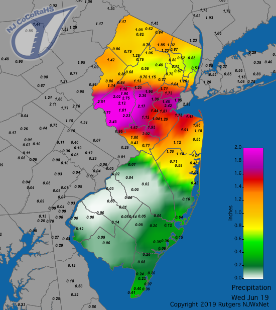 Figure 1. Rainfall from about 7AM on May 7th to 7AM on May 8th. Observations are from CoCoRaHS stations.
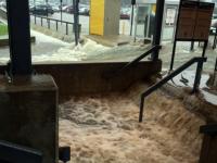
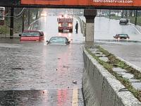
Yet more rain dotted the state on the 19th into the 20th. A series of moisture-laden storms pounded western portions of Gloucester and Camden counties and a good portion of Burlington County from the afternoon of the 19th into the early hours of the 20th (Figure 2). This resulted in flash flooding of local streams and rivers, along with the overtopping of several dams and the inundation of some neighborhoods and roadways. Exceptionally heavy rain fell first in Burlington County during the afternoon and evening and then, after midnight, close to the Delaware River in western Gloucester and Camden counties, back into Burlington. Tabernacle led the way with 8.03”, followed in Burlington County by Medford Lakes at 5.76”, Southampton 4.90”, and Medford Township 4.68”. West Deptford received 5.42”, and in Camden County, Cherry Hill received 4.60” and Mount Ephraim 4.41”. Six other Burlington County stations had 2.83”–3.50”, with 12 stations in six nearby counties between 1.00”–2.05”. Rivers and creeks such as the Cooper, and North and South Branches of the Rancocas rose as much as 7 feet ,with over 60 times the normal amount of water flowing downstream. Damage was done to some homes and farmland. Gusts downed some trees in Ocean County.
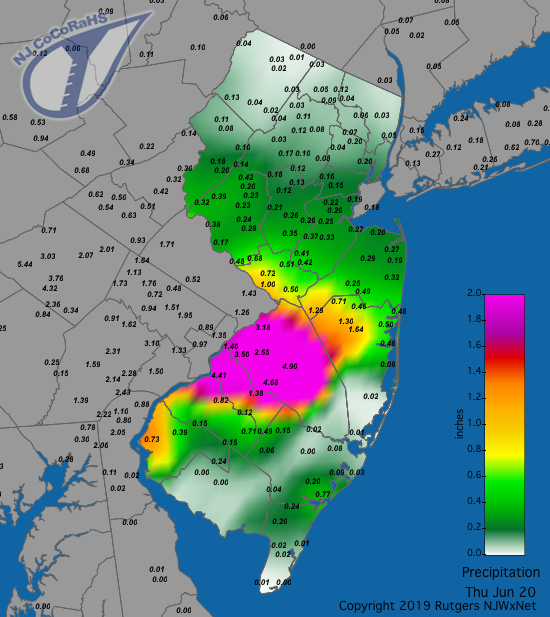 Figure 2. Rainfall from about 7AM on June 19th to 7AM on June 20th. Observations are from CoCoRaHS stations.
Rain returned during the second half of the 20th, with a line of moderate thunderstorms crossing a good portion of NJ. Later, some heavy rain moved into coastal south Jersey, which had been quite short on moisture to this point in the month. Rain tapered off by early afternoon and a period of drying out began. This event produced as much as 2.69” at Pine Beach (Ocean), followed by two Toms River (Ocean) locations with 1.89” and 1.83”, four Lower Township (Cape May) stations ranging from 1.70”–1.80”, North Wildwood (Cape May) 1.74”, and up north, Ringwood (Passaic) with 1.71”. Some 61 CoCoRaHS locations caught 1.00”–1.67”.
A line of showers traversed northern and central areas in the pre to post dawn hours of the 25th. While some additional rainfall in the northeast appears on the next day’s map, Figure 3 shows the bulk of what fell in the event that targeted the zone between Interstates 78 and 80. Mt. Olive (Morris) received 2.11”, Califon (Hunterdon) 2.05”, Chatham (Morris) 1.85”, and Lebanon 1.74”. Some 40 CoCoRaHS stations caught between 1.00”–1.73”.
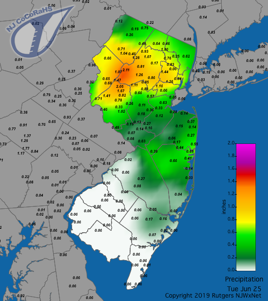 Figure 3. Rainfall from about 7AM on June 24th to 7AM on June 25th. Observations are from CoCoRaHS stations.
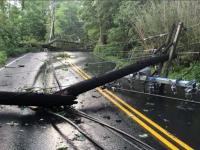
The month closed with a fast-moving squall line impacting the bulk of the state during the afternoon and evening of the 29th. The rainfall was generally not heavy, though Andover (Sussex) caught 1.30”, Long Branch (Monmouth) 1.03”, Manchester (Ocean) 0.94”, Woodland Township (Burlington) 0.91”, and Mine Hill Township (Morris) 0.90”. However, hail was reported in several locations, including up to golf ball size in West Long Branch (Monmouth), nickel to quarter size and South Harrison (Gloucester), and 3/8” in diameter in Winslow (Camden) and Randolph Township (Morris). Winds howled in many locations, bringing down trees and powerlines. Peak gusts included 54 mph in Upper Deerfield (Cumberland), Pennsauken (Camden) 53 mph, Lower Alloways Creek Township (LACT; Salem) 49 mph, Berkeley Township (Ocean) and Fortescue each at 48 mph, and Mullica (Atlantic) 46 mph. Six other NJWxNet stations gusted from 40–43 mph, with 20 others from 30–39 mph.
In addition to the reports from the 29th, gusts peaked at 40 mph or higher at NJWxNet stations on nine other June days. The 2nd produced the strongest gusts, with LACT up to 56 mph, Harvey Cedars (Ocean) 47 mph, Mannington (Salem) 46 mph, and Hillsborough-Duke (Somerset), Berkeley Township, and Woodbine each up to 40 mph. Moorestown (Burlington) reached 40 mph on the 3rd. High Point Monument (HPM; Sussex) hit 46 mph on the 11th. Mannington topped out at 47 mph, LACT 42 mph, and South Harrison 40 mph on the 13th. HPM was up to 45 mph on the 14th, Mullica Township 43 mph on the 17th, and Sea Girt (Monmouth) 43 mph on the 20th. The 21st brought a 41 mph gust to Fortescue and 40 mph gusts to LACT and HPM. HPM reached 40 mph on the 30th.
The highest barometric pressures for the month occurred on the 21st in the 30.25”–30.35” range. Lowest pressures were found on the 21st, bottoming out between 29.40”–29.50”.
Temperature
An examination of the 65 NJWxNet stations reporting temperatures in June found 17 afternoons with maximums topping out at 85° or higher at one or more locations. This included the 2nd, 5th–6th, 8th, 16th–20th, and 23rd–30th. Of these days, six noted maximums of 90°or higher. There were 13 days with minimums of 49° or lower, with a June freeze just being missed at Walpack on the 4th.
On the maximum side, Woodbine, Oswego Lake (Burlington), Sicklerville (Camden), and Vineland (Cumberland) each reached 85° on the 2nd. Five stations achieved 86° on the 5th with 27 closely behind at 84°–85°. Egg Harbor Township hit 88° on the 6th with six other stations at 87°. LACT reached 85° on the 8th. Over a week passed without reaching the 85° mark until a five-day stretch kicked in on the 16th with Vineland and Sandyston (Sussex) up to 87°, Upper Deerfield 86°, and 17 locations at 85°. Next came a three-day period where the southern half of NJ under partly cloudy skies broke into the 80°s, while more extensive clouds kept the north considerably cooler. On the 17th, Cape May Courthouse (CMCH; Cape May) topped out at 90°, and Vineland, Woodbine, and LACT at 89°, with 17 stations from 85°–88°. Meanwhile HPM only touched 70°. More pronounced were differences on the 17th, with CMCH at 88°, West Cape May (Cape May), Egg Harbor Township, and West Creek (Ocean) each at 86°, while HPM only reached 65°. This was also the top mark at HPM on the 18th, with six southern stations up to 86°. The 20th found Woodbine and CMCH reaching 90°, with 89° at Oswego Lake and Vineland, 32 sites from 85°–88°, and HPM warming to just 73°.
While the 85° mark was not achieved on the 22nd, a partly sunny, windy day statewide brought maximum temperatures at all NJWxNet stations to between 75°–83°, with the exception of the cooling northwesterly winds keeping HPM at 71°. In fact, 34 of the 65 stations sat at 81° or 82° for a maximum, with only Woodbine sneaking up to 83
Five locations reached 86° and ten 85° on the 23rd. Mansfield (Burlington), Upper Deerfield, and West Deptford hit 88° on the 24th. Maximum temperatures were tightly packed on the 25th, the first day of the year with all NJWxNet stations at 80° (at HPM) or higher. Mansfield reached 88°, with 15 stations at 88°. A four-day run of 90° weather began on the 26th, with six stations at 91° and 11 at 90°. The 27th found Woodbine up to 94° and 44 stations from 90°–93°, with HPM making it to 80°. Sicklerville reached 95°, seven stations maxed out at 94°, and 33 were from 90°–93° on the 28th, with four coastal stations on the low end at 81°–83°. The heatwave peaked on the 29th, with the 95° mark achieved at Berkeley Township, Egg Harbor Township, Pennsauken, Sicklerville, and Vineland. Some 45 stations saw maxes range from 90°–94°, with HPM “coolest” at 82°. Atlantic City Marina (Atlantic), CMCH, and Vineland made it up to 89° on the 30th.
The coolest daily minimum temperatures were most commonly found in the Sussex County valley locations of Sandyston and Walpack. However, at times, other locations situated away from the coast and urban centers fell to rather chilly levels. The 3rd was the first occasion where one or more stations bottomed out at 45° of lower. Walpack was 40°, Sandyston 41°, Pequest (Warren) 43°, and four other sites 44°–45°. The 4th was by far the coolest morning of the month. Walpack dipped to a frosty 33°, followed by 37° at Sandyston and Pequest, 38° in Hopewell Township (Mercer), 39° in Berkeley Township and Basking Ridge (Somerset), with 27 stations from 40°–45°. Harvey Cedars was mildest at 58°.
Walpack fell to 42° on the 9th, with three stations at 45°. Walpack was 44° on the 10th and 45° on the 11th. Walpack dropped to 37° on the 12th, with Sandyston 40°. Walpack was 45° on the 14th and 40° on the 15th, when Sandyston reached 42°. Walpack was 45° on the 22nd and 44° on the 23rd.
A sure sign that coastal waters are warming is when daily minimums at stations near the water begin to remain at or above 70°. Of course, warm and humid conditions can also keep the thermometer in the 70°s or (rarely) 80°s at night across much of NJ, posing an unhealthy situation for individuals without artificial means of cooling off. This year, the first 70° night was in southwest NJ away from the coast when eight stations on May 20th bottomed out from 70°–72°. The warming waters of Delaware Bay brought minimums of 70°–71° at Fortescue on May 29th–31st.
Come June, 70° minimums held off until mid-month, with the exception of the 6th when some coastal and some interior southwest stations only fell to 70°–71°. Summer really began to blossom come the 16th, with only the 22nd and 23rd failing to have a station at 70° or higher for a minimum over the remainder of the month. The warmest morning was the 25th, when 31 stations had lows of 70°–74°, with Fortescue and fellow Delaware Bay shoreline station LACT only down to 75°.


