ENSO

What Can NJ Expect from El Niño Going into Spring?

March 1, 2016 - 5:13pm -- Ariel Schabes

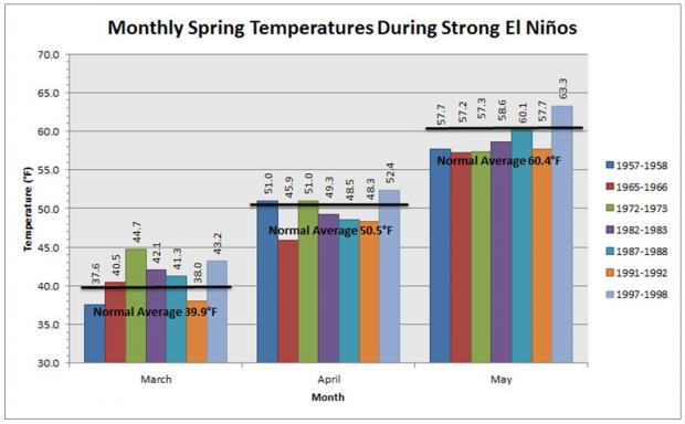
Spring temperature anomalies during past strong El Niños.

Following a winter of widely-varying conditions, likely in part due to the influence of the major El Niño event that has been underway since last fall, it is useful to look back at past spring weather in years that, like this year, experienced strong El Niños. While certainly not providing a definitive forecast for what we might see over the next several months, this exercise will provide some insights into what might be seen. Here, much as we have done for summer, fall, and winter we will examine the seven strongest El Niño events since 1950.

Looking first at temperature, March was warmer than average in five of the seven years, while for April and May, temperatures tended to be below to well-below average. In fact, only two of the 14 Aprils and Mays averaged more than a half-degree above average, while nine averaged a degree or more below average.

With an El Niño underway, how much of an impact can we expect it to have on NJ's summer weather?

July 23, 2015 - 2:29pm -- Dave Robinson

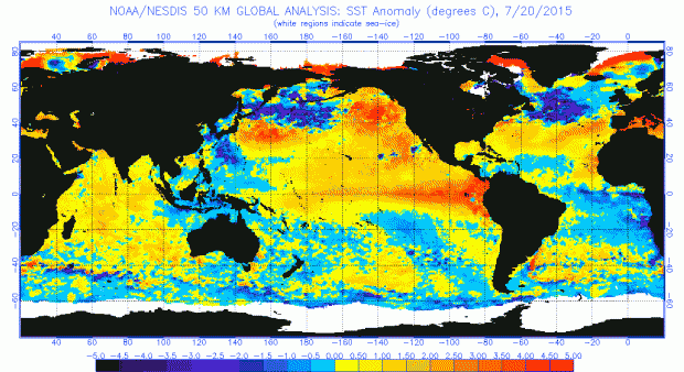
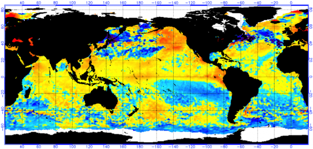
Sea Surface Temperature (SST) anomalies for July 20, 2015.  NOAA/NESDIS.

Scientists are carefully monitoring sea-surface temperatures in the tropical Pacific Ocean for a potential El Niño event. An El Niño occurs when warmer-than-average waters start to form in the eastern Pacific Ocean, specifically near the equatorial latitudes. Easterly winds (blowing from the east) typically move warmer water to the western Pacific (near Indonesia), permitting cooler water to upwell to the surface in the east (near South America). When these winds are weaker, or if they reverse direction, the warm water stays in the eastern Pacific. This difference in sea surface temperatures and winds creates a new dynamic between the ocean and atmosphere, distinctly affecting weather patterns across the world. No two El Niño events are alike; they vary in magnitude and location of the largest temperature anomalies. El Niño events can be classified as Strong, Moderate or Weak.

Winter Weather Trends: El Niño in New Jersey

December 19, 2014 - 4:41pm -- Jack McCarty

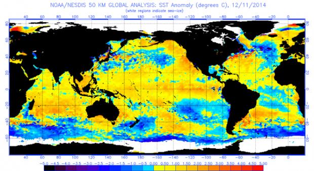
Global Sea Surface Temperature Anomalies

As we have mentioned in our past evaluations of the El Niño’s significance in the summer and fall, we are back again to analyze the wintertime impacts of a developing El Niño on New Jersey weather. An El Niño occurs when warmer-than-average waters exist in the central and eastern Pacific Ocean, specifically near the equatorial latitudes. This warming is due to a weakening of winds moving to the west, which typically transport warmer waters to the western Pacific, permitting cooler water to upwell to the surface in the east. When these winds are weaker or if they reverse direction, warm water stays in the east. The warmer sea surface temperatures in the east and the altered atmospheric flow pattern create a new dynamic between the ocean and atmosphere. The newly formed interaction sets up distinct and repetitive weather patterns across the world. No two El Niño events are alike; they vary depending on the magnitude and location of where the largest temperature anomalies are found. However, each one tends to alter weather patterns outside the overall norm.

El Niño Potential: Fall Impacts

October 15, 2014 - 10:12pm -- Jack McCarty

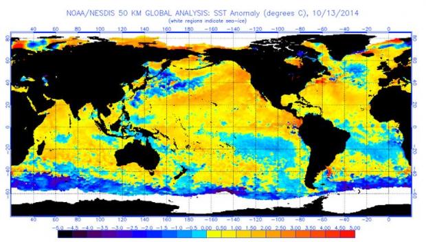
Sea Surface Temperature Anomalies

Early this past summer, we reported on the potential impacts of a developing El Niño event in the tropical Pacific on summertime weather in New Jersey. While El Niños can impact the weather worldwide, we found that New Jersey's weather doesn't fluctuate with an El Niño event. This year's summer (June-August) proved to be rather comfortable, with the statewide average temperature 0.8° below the 1981-2010 average , and precipitation 0.26” above the 1981-2010 average. These mild conditions replicated what we expect out of an El Niño summer. Now we’re back to tell you the story for the fall.

Potential El Niño could impact New Jersey weather this summer

May 30, 2014 - 5:11pm -- Dan Zarrow

Map of impending El Nino

As climatological summer and the Atlantic hurricane season begin on June 1, scientists are carefully monitoring sea-surface temperatures in the tropical Pacific Ocean for a potential El Niño event. An El Niño occurs when warmer-than-average waters start to form in the eastern Pacific Ocean, specifically near the equatorial latitudes. Easterly winds (blowing from the east) typically move warmer water to the western Pacific (near Indonesia), permitting cooler water to upwell to the surface in the east (near South America). When these winds are weaker, or if they reverse direction, the warm water stays in the eastern Pacific. This difference in sea surface temperatures and winds creates a new dynamic between the ocean and atmosphere, distinctly affecting weather patterns across the world. No two El Niño events are alike; they vary in magnitude and location of the largest temperature anomalies. El Niño events can be classified as Strong, Moderate or Weak. What might an El Niño summer mean for New Jersey's weather?

Subscribe to RSS - ENSO