Tornado

Scorching: June 2024 and January–June Recaps

July 7, 2024 - 2:17pm -- Dave Robinson

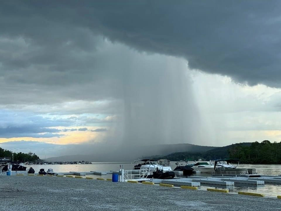
Photo of a rain shaft over lower Greenwood Lake (Passaic County) taken from Hewitt on June 7th (photo courtesy of Rich Stewart).

Above-average temperatures ruled in June. So, what else is new? As will be seen later in this report, the first half of 2024 ranked as the second warmest since statewide records commenced in 1895. June 2024 was also the 7th consecutive month with temperatures above the 1991–2020 average and 10th of the last 12 in that category. June itself came in as New Jersey’s 2nd warmest, tied with 1943 and just behind 2010. Six of the 11 warmest have occurred since 2005. The 73.6° average was 3.3° above normal. The average high of 85.1° was 4.1° above normal, tied for the 2nd warmest, and the average low of 62.0° was 2.4° above normal, ranking 4th warmest. Each of the three NOAA state climate divisions had their 2nd warmest June. The north averaged 71.7° (+3.1°), south 74.8° (+3.4°), and coast 73.8° (+3.3°).

As often occurs during the warm season, the rainfall pattern was a mixed bag as the month progressed and also across the state on any given day. Overall, the state experienced a dry month, with the majority of the state considered Abnormally Dry (D0) in the last US Drought Monitor assessment of the month. With some rain falling after the June 30th approximate 7–8 AM observing time of most National Weather Service Cooperative and Community Collaborative Rain, Hail, and Snow Network (CoCoRaHS) stations, any daytime or evening rain is entered into the record book as falling on July 1st. Thus, the official map below does not include some of the heavy post-observing time heavy rain in Cape May County the morning of the 30th nor rain occurring elsewhere in the state later in the day. For the month, the state average 2.74”, which is 1.56” below normal and ranks 28th driest. The north averaged 2.23” (-2.38”, 13th driest), south 3.07” (-1.07”, 49th driest), and coast 2.84” (-1.01”, 51st driest).

Strange, Just Plain Strange: June 2023 Recap, Plus First Half of 2023 Review

July 11, 2023 - 9:38pm -- Dave Robinson

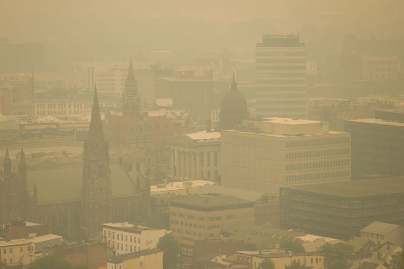
Wildfire smoke blankets downtown Paterson (Passaic County) on June 7th. Photo by Steve Hockstein/NJ Advance Media.

There is rarely a month in New Jersey where something interesting, exciting, and different than normal doesn’t occur in the weather and climate department. However, not often do you find a month like this past June where one is left with their head spinning as smoke from near and distant wildfires darkened the sky, creating exceptionally unhealthy air quality, where growing drought concerns were quieted in most locations by late-month downpours, where two tornadoes touched down, and with temperatures averaging cooler than normal for the second consecutive month. Strange, indeed.

June temperatures across the state averaged 67.8°. This was 2.5° below the 1991–2020 mean and tied as the 36th coolest June since 1895. The average daily maximum temperature of 79.0° was 2.0° below normal and ranks 40th coolest. The daily minimum averaged 56.6°, 3.0° below normal and was 35th coolest. The northern NJ climate division averaged 66.1° (-2.5°, 33rd coolest), the southern division averaged 68.9° (-2.5°, 36th coolest), and the coastal division averaged 68.2° (-2.3°, 45th coolest). Both May and June averaged below normal, the first such back-to-back occurrence in NJ since April and May 2020.

NJ June precipitation averaged 3.87”. This was 0.43” below normal, however, it ranks as the 53rd wettest of the past 129 years (or 77th driest) due to the skewed nature of the distribution of monthly precipitation over this period. The north averaged 5.13” (+0.52”, 29th wettest [101st driest]), the south 3.19” (-0.95”, 51st driest [79th wettest]), and the coast 2.20” (-1.65”, 28th driest [102nd wettest]).

An Odd One: April 2023 Recap

May 8, 2023 - 5:15pm -- Dave Robinson

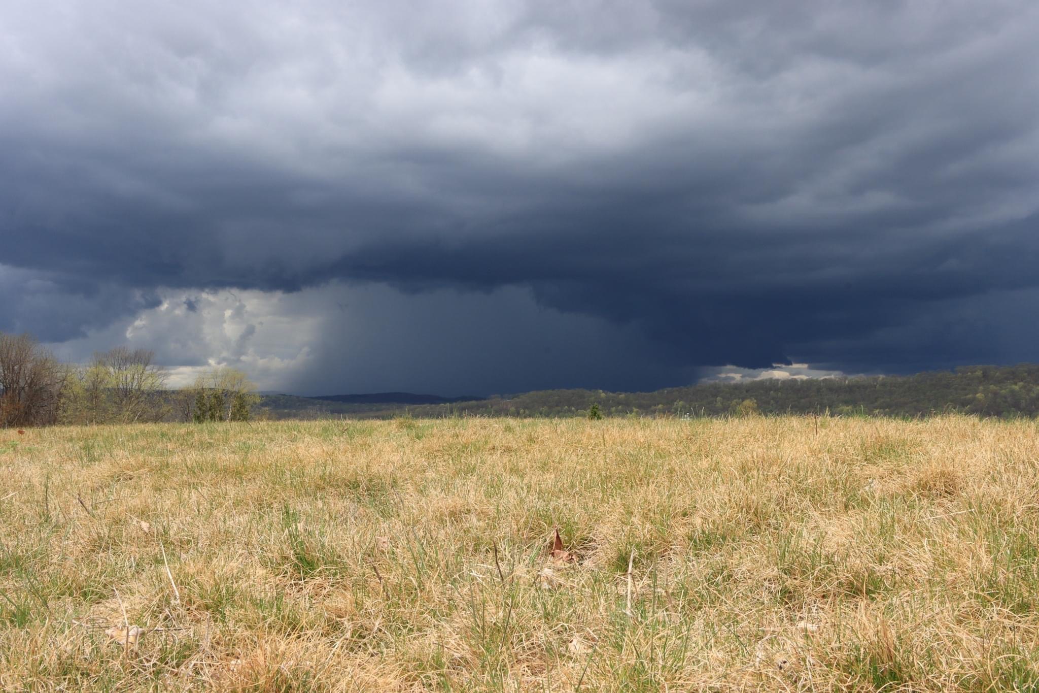
A vivid rain shaft accompanies a thunderstorm as seen from Hardyston Twp. (Sussex County) on April 15th, 2023. Photo courtesy of Yulia Karpova.

What can you say about a month that began with a swarm of tornadoes, finished with flooding rain, and in between, featured record heat, wildfires, and increasing drought concerns? Best to say that it was an odd one! Fitting this theme, the statewide average temperature of 55.4° was 3.9° above the 1991–2020 normal. This ranks as the third warmest April on record (since 1895) only behind 2017 and 2010 for top honors. April was the fifth month of the past ten ranking in the top 10, joining July (#7), August (#1), January (#1), and February (#5). The first four months of 2023 come in as the warmest start of the year on record with an average of 44.4°. This exceeds the previous record of 44.2° in 2012, with seven of the 10 warmest January–April periods (1895–present) occurring since 2002. The average April maximum temperature across NJ was 67.4° (+4.7°, 3rd warmest) and the average minimum was 43.4° (+3.1°, 5th warmest). Northern counties averaged 53.5° in April (+3.6°, 5th warmest), southern counties 56.6° (+4.0, 2nd warmest), and the coastal zone 55.8° (+4.1°, 2nd warmest).

April precipitation averaged 5.84” across New Jersey. This was 2.14” above normal, ranking as the 10th wettest on record. It was the wettest April since 2007 and second wettest since 1983. All but scattered areas in the northwest received above-normal precipitation, the greatest amounts falling near the Atlantic and Delaware Bay coasts. Northern counties averaged 5.55” (+1.65”, 26th wettest), southern counties 6.04” (+2.49”, 7th wettest), and the coastal zone 5.94” (+2.39”, 10th wettest). It is important to note that these totals and those for individual stations in the next section, do not include heavy rain that fell after standard early morning observation times at CoCoRaHS and National Weather Service Cooperative stations on April 30th. These rains were reported in morning observations on May 1st, thus will be included in May totals.

Normally Abnormal: February 2023 & Winter 2022/2023 Recaps

March 7, 2023 - 4:28pm -- Dave Robinson

Tornado damage in the Lawrence Square Village housing complex in Lawrence Twp. (Mercer County) after an EF2 tornado tore through the area on the afternoon of February 21st. Photo by Michael Mancuso/NJ Advance Media.

Abnormal conditions were seemingly the norm cross the Garden State during the second month of 2023 and, for that matter, during much of the winter (December–February). More on winter later in this report. First, focusing on February, milder-than-normal temperatures and limited snowfall were the rule, a short-lived frigid blast was followed by 70° warmth, and the most notable February tornado of at least the past 74 years touched down.

The statewide average temperature of 38.9° was 5.0° above the 1991–2020 normal and ranked as the 5th mildest February since 1895 (tied with 2012). Five of the six mildest Februarys have occurred in the last 11 years. Exemplifying the warmth, the New Brunswick (Middlesex County) Cooperative station experienced 23 days with above-average temperatures and just five below average. The same was true at both Sussex (Sussex) and Newark Airport (Union). Atlantic City Airport in Pomona (Atlantic) had 18 above and ten below normal, and Cape May (Cape May) reported 21 above and seven below.

The average February maximum was 49.3°, which is 6.2° above normal and ranks 3rd mildest, while the average minimum of 28.5° was 3.9° above normal, ranking 7th mildest. Temperatures in the northern climate division averaged 36.0° (+4.7°, 7th mildest), southern 40.6° (+5.1°, 4th mildest), and coastal 41.1° (+5.1°, 3rd mildest).

Ida Remnants Strike New Jersey

October 6, 2021 - 2:59pm -- Dave Robinson

Photo of flood debris from business establishments on Main Street in Manville on September 7 (photo credit: M. Holzer).

Post tropical storm Ida moved across the Garden State during the afternoon of September 1st into the early hours of the 2nd. It brought with it torrential rainfall, leading to flash and river flooding that took the lives of approximately 30 individuals and the rescue of countless more from raging waters. Additionally, it brought three tornadoes to southwestern and central areas, including the first EF-3 twister to strike New Jersey in 31 years. There were only minor injuries and no deaths from the tornadoes.

Ida developed in the Caribbean, being named a tropical storm on August 26th. From there, it moved northwestward, attaining hurricane status on the 27th as it passed over extreme western Cuba and moved into the Gulf of Mexico. It maintained a steady course as it strengthened into a major category 4 hurricane, making landfall in Louisiana on the 29th with sustained one-minute wind speeds as high as 150 mph. Once inland, winds diminished rather quickly but rainfall associated with the tempest remained heavy as the storm began to curve toward the northeast. This track remained quite steady as the storm weakened to a tropical depression on the 30th and became an extratropical low-pressure system as it approached the central Appalachians. On September 1st, Ida’s remnants merged with an advancing cold front as the system entered the Mid-Atlantic and crossed New Jersey before moving into southeast New England on the 2nd.

Everything but the Kitchen Sink: July 2021 Recap

August 5, 2021 - 7:55pm -- Dave Robinson

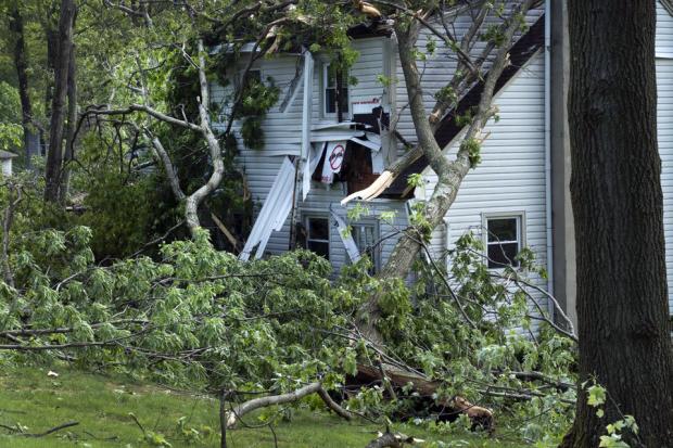
Tornado damage

Wow, what a month. July 2021 provided a never-ending cascade of weather events, including a tropical storm, a record-tying number of tornadoes, large hail, flash floods, hot days, chilly nights, smoke-filled skies, and on the last day of the month, perhaps the nicest day of the summer. The statewide average precipitation of 7.59” was 2.88” above the 1991–2020 normal and ranked 8th wettest of all Julys back to 1895. It was the wettest July since 1975 and second wettest in almost 50 years. The northern portion of the state averaged 8.16” which was 3.44” above normal. The south averaged 7.36” which was 2.62” above normal.

The average temperature of 75.8° was 0.4° above the 1991–2020 normal, but 1.9° above the 1895–2021 average. This ranked as the 24th warmest July since 1895. 13 of the 25 warmest Julys in the past 127 years have occurred since 2002. The nine July tornadoes is the most in a month since official records began in 1950. Tropical Storm Elsa was the earliest fifth storm of any season on record in the Atlantic basin. Read on for details on this potpourri of weather happenings.

Mother Nature Picking on Two NJ Communities!: July 2019 Recap

August 4, 2019 - 2:30pm -- Dave Robinson

Thunderstorm wind damage in Holmdel

With 565 incorporated communities in New Jersey, one would think that the odds of multiple significant weather events specific to any one of them within a month would be exceedingly rare. Yet July 2019 brought such a duel scenario to not one but two NJ townships. Mt. Laurel (Burlington County) was visited by two tornadoes, while one rain gauge in Stafford Township (Ocean) caught 5.00” in two separate 24 hour periods. More specifics are provided later in this report. The good news is that, despite damage occurring in each of the four events, there were no fatalities nor reported injuries.

The month as a whole was a wet one, averaging 6.15” across the state. This is 1.58” above the 1981–2010 mean and ranks as the 20th wettest since 1895. Northern counties were wettest, averaging 7.20” or some 2.45” above normal and ranking 16th wettest. The south averaged 5.61”, which is 1.12” above normal and ranks 29th wettest.

Ten of the past 12 months and 15 of the past 18 months have received above-average precipitation across the state. While the 12 months ending in January this year ranks as wettest (66.61”) of 1484 such intervals dating back to 1895, the past 12 month period ending in July comes in second place with 65.74”, just ahead of the 12 months ending in June (65.50”).

Frequently Wet: May and Spring 2019 Recaps

June 5, 2019 - 11:08pm -- Dave Robinson

Stanhope tornado damage

As was seen earlier this spring, rainfall was quite persistent during a good portion of May. However, unlike April, it was not just a matter of frequency but ultimately, quantity that made for soggy conditions in the fifth month of 2019. The statewide average precipitation was 6.70”, which is 2.71” above the 1981–2010 mean. This made for the 9th wettest May since records commenced in 1895. The northern half of NJ was wettest, averaging 8.69” (+4.35”), making it the 3rd wettest on record. Only May 1989 (10.13”) and 1984 (9.79”) saw more rain. The south averaged 5.52” (+1.72”), ranking 17th wettest.

Based on observations from 62 NJWxNet stations, there were only two calendar days (22nd and 25th) without measurable (0.01”) rainfall at any location. Three days saw a maximum of 0.01”–0.10” at one or more stations, nine with a maximum between 0.11”–0.25”, and eleven topping out from 0.26”–0.99”, while on six days one or more station received an inch or greater.

The wet conditions were accompanied by above average temperatures. The 62.7° statewide average was 2.1° above the 1981–2010 mean. This ranked as the 19th mildest May on record (tied with 1985). However, it is only the 8th warmest May since 2004. Ten of the past 12 months have been above average.

A Potpourri of Weather: June 2017 Summary and Mid-Year Recap

July 5, 2017 - 5:19pm -- Dave Robinson

Rainbow photo

Occasionally there are months that defy a “directional” theme when it comes to the weather and climate conditions experienced across the Garden State. In other words, conditions didn’t lean markedly toward, for example, wet or dry, cold or warm, or calm or stormy. June 2017 was one of those “potpourri” months. There were thunderstorms with drenching rain and even two tornadoes occurred, yet there were stretches of comfortable, dry weather. There was a three-day heat wave, with the temperature going as high as 97°, and some cool nights, with 35° being the coldest observed temperature in the state. When the precipitation was added up, the statewide average came out to 3.34”, which was 0.67” below the 1981–2010 mean of 4.01” and ranks as the 54th driest June of the past 123 years. The statewide average temperature of 70.5° was 0.7° above average. This ranks as the 27th mildest June on record.

A Tranquil October (Imagine That!): October 2013 Summary

November 4, 2013 - 12:00am -- Dave Robinson

Damage from tornado in Paramus on October 7th. Photo Credit: Michael Harger
Following the past two October 29ths, it was wonderful to see sunny skies and seasonable maximum temperatures ranging from the mid to upper 40°s in the northwest to the low to mid 60°s in south this 29th. As a matter of fact, aside from a strong frontal passage blowing through the north on the 7th and a stubborn coastal storm impacting the south from the 9th-12th, conditions were quite tranquil throughout most of October 2013. A summer-like first week was the major contributor to the statewide monthly average temperature of 57.1° coming in 2.3° above normal. This ties with 1950 and 1951 as the 20th mildest October since statewide records commenced in 1895.

Pages

Subscribe to RSS - Tornado