
ONJSC's Top 10 NJ Weather and Climate Events of 2024
 on October 24th, 2024, revealing a \"ghost bridge\" that had been used by stagecoaches on the original roadbed of the Paterson-Hamburg Turnpike. Photo by Andre Malok/NJ.com.")
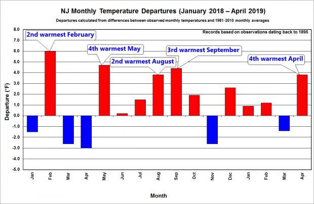
For the 16th consecutive year, we in the state climate office have evaluated the myriad daily, monthly, and annual observations gathered across New Jersey during the course of the year to choose what we feel were the most significant and impactful 10 weather and climate events of 2024. More about each event can be found in the monthly narratives posted on our website. You might be tempted to rearrange the rankings, particularly as some of the events on the list may have affected you more than others ranked higher. Or perhaps you best recall one that didn't make the list. That's the enjoyment and frustration of lists! Unless stated otherwise, statewide values are based on an average of several dozen stations. The period of record for monthly, seasonal, and annual departures is 1991–2020; while for extremes and rankings it is from 1895–present. Observations are mainly drawn from National Weather Service Cooperative Observing Program stations, Rutgers NJ Weather Network (NJWxNet) stations, and NJ Community Collaborative Rain, Hail, and Snow Network (CoCoRaHS) locations.
 on August 24th. While August 22nd rain proved beneficial, the water level is normally higher. Photo taken by D. Robinson.")
 on September 2nd following the staggering rainfall caused by the remnants of Ida. Photo by Thomas P. Costello and Tariq Zehawi/USA Today Network.")
 on August 22. Photo by Mayor Chris Slavicek.")

 on July 1st. In addition to the visible hail in the left image and the damage to crops in the right, notice the fog that formed when the milder humid air met the hail-cooled surface. Photos from the New Jersey Farm Bureau Facebook page.")
 on Long Beach Island. Photo by Kerri Mazzella.")
 at the end of September. Photo by Dave Robinson.")
 scenes on April 29, 2018 (top), and 2019 (bottom), demonstrating that spring 2019 experienced a green up that was noticeably earlier than 2018. Photos by Doug Robinson.")