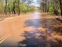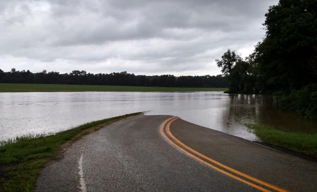
Flooding along Weber Road in Upper Deerfield (Cumberland County) on July 14. Photo by Layne Ball.
Overview
In most respects, July 2015 was a rather common one in the weather department. The statewide average temperature of 75.5° was 0.5° deg above the 1981–2010 mean. This past June had the same positive anomaly. This ranks as the 28th warmest July since 1895. It may seem strange to have such a small departure from normal yet rank in the top quartile for warmth. This can be explained by the fact that New Jersey has gotten warmer since the end of the 19th century. Compared to all Julys since 1895, this past July was 1.3° above average. Again, this might not seem like a large difference, however, given that temperatures do not vary from year to year nearly as much in summer as in winter, this change over the past century is notable.
July precipitation averaged 4.08". This is 0.44" below normal and ranks as the 55th driest July of the past 121 years. If you are wondering, the full period of record July precipitation averages just 0.02" less than the 1981–2010 mean. Of course, as is often the case during the showery summer months, rainfall varied considerably from one location to another. It ranged from 9.61" at Montague (Sussex County) to 1.46" in Maplewood (Essex), even with these communities just 50 miles apart. There were three days when local deluges exceeded 4.00" over just several hours. Each resulted in flash flooding, though just miles away considerably less rain fell.
Temperature
While July maximum temperatures were not excessively high, they were generally consistently warm and at times were accompanied by considerable humidity. Twelve afternoons saw temperatures equal or exceed 90° at one or more of the 55 NJWxNet stations, two thirds occurring during the last half of the month. It was not until the 7th that this mark was achieved, when Hamilton (Mercer) and Hawthorne (Passaic) reached 91° and nine other stations hit 90°. The next day, Cape May Court House (Cape May), Oswego Lake (Burlington), and South Harrison (Gloucester) came in at 92°. New Brunswick (Middlesex) was 90° on the 12th and Hamilton (Mercer) hit that mark on the 13th.
The 19th and 20th share top honors for the hottest July 2015 days. The National Weather Service station at Newark Liberty International Airport (Essex) recorded the state's highest temperature of 98° on the 19th. Hawthorne reached 97° that day, followed by 96° in both Hamilton (Mercer) and Haworth (Bergen). 43 NJWxNet stations maxed out at 90° or higher, while Harvey Cedars (Ocean) was "coolest" at 82°. The next day, Jersey City (Hudson) reached 96°, with six stations at 95°. 44 stations were at least 90° and High Point Monument (Sussex) had the lowest maximum at 82°. Mansfield (Burlington) reached 92° on the 21st, with five stations at 91°.
Hamilton (Mercer), Hillsborough (Somerset), New Brunswick, and Oswego Lake all came in at 90° on the 26th. On the 28th, some locations away from the hills or coast began a three-plus-day run (extending into early August) of maximums reaching 90°. Hawthorne and New Brunswick led the way at 95° on the 28th, with these two stations joined by Hillsborough at the 96° mark on the 29th. Woodbine (Cape May) topped the list at 92° on the 30th, with five locations at 91°. The last day of the month saw Jersey City, Oswego Lake, and Toms River (Ocean) at 92°.
A recipe of calm, clear nights with relatively low humidity levels made for some comfortable sleeping conditions on a number of occasions. This was particularly true at inland valley locations. Twelve nights saw the thermometer drop to 55° of cooler at one or more spots. Pequest (Warren) began the count at 54° on the 2nd. Pequest and High Point (Sussex) fell to 51° and 53°, respectively, on the 3rd, with High Point to 55° on the 5th. Pequest and Walpack (Sussex) fell to 55° on the 11th and 54° on the 12th. Walpack was 48° and three stations 50° on the 16th. The chilliest morning of the month occurred on the 17th when Walpack reached 49°, Pequest 50°, and 13 other stations fell to 51°–55°.
Walpack and Pequest were the coolest stations in the state from the 22nd–25th, with consecutive readings of 50°, 47°, 49°, and 48° at Walpack and 52°, 49°, 49°, and 49° at Pequest. Walpack reached 55° on the 31st, which was the only July day with a Jersey station at 55° or lower and another at 90° or higher.
The most uncomfortable night of the month was the 19th into the 20th, when, accompanied by high levels of humidity, Lyndhurst (Bergen) only dropped to 80°. Eight stations had 79° minimums and 50 of the 55 NJWxNet stations remained at or above 70°. Most often it was coastal locations that stayed mild overnight. The temperature failed to drop below 70° on 21 nights at Atlantic City Marina (Atlantic), and this location's monthly minimum was only 65°. Meanwhile, Walpack had a monthly maximum low of 67° and only stayed out of the 40°s or 50°s on 12 nights.
Precipitation and Storms
The 9.61" and 1.46" extreme monthly totals at Montague and Maplewood were mentioned previously. It is worth noting that 2.45" of the Montague total fell after the standard morning observation time on June 30th thus is counted toward the July total. Other wet locations included Franklin Township (Gloucester) at 9.34", Upper Deerfield (Cumberland) 7.40", Folsom (Atlantic) 7.01", Estell Manor (Atlantic) 6.95", Buena Vista (Atlantic) 6.76", Pittsgrove (Salem) 6.36", and White Township (Warren) 6.24". Among the drier locations were Eatontown (Monmouth) 1.51", Cranford (Union) 1.51", Woodbine 1.53", and Mine Hill (Morris) 1.79". As these and many other totals indicate, the southern (except Cape May County) and northwestern areas of the state received generally adequate rainfall in July. Central, northern coastal, and northeast counties were driest, with lawns and fields at month's end beginning to show signs of stress for the first time since late May.
There were several July days that brought scattered showers where rainfall was not significant (e.g., 6th, 7th, 18th). The discussion that follows only covers events that brought an inch plus to one or more of the close to 300 NJ CoCoRaHS and NJWxNet stations.
The afternoon and evening rain of June 30th was local in the northwest, however, early on the morning of the 1st there was a more widespread event that deposited 1.74" in Mansfield (Warren), 1.72" at Lyndhurst, and 1.33" in White Township. Most of north Jersey had at least 0.50", with similar amounts near the Delaware River in southwest NJ. Heavy showers were localized to Cape May and far southern Atlantic counties on the afternoon and evening of the 2nd, with 1.45" in Cape May, 1.34" at Wildwood Crest, and 1.26" in West Cape May (all in Cape May). The second half of the 7th saw 1.05" fall in Lawrence Township (Mercer) and 1.03" in Brick Township (Ocean), as Mercer and eastern Ocean and Monmouth saw most of the rain. Afternoon and evening thunderstorms on the 9th concentrated along a line from western Cumberland County northeast to eastern Ocean, with lighter rain in north Jersey. Stafford Township (Ocean) saw 1.76", Folsom 1.55", Buena Vista 1.52", and Upper Deerfield 1.50". They brought down some trees and power lines in Camden and Gloucester counties. Rainfall exceeded 0.50" in many locations, with 1.42" in Burlington (Burlington), 1.41" at Mansfield (Burlington), Blairstown (Warren) 1.29", and Hamilton (Mercer) 1.15". These were the counties with pockets of heaviest rain.
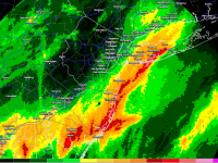
Unsettled conditions on the mornings of the 14th and 15th included deluges in two southern areas, with much less rain elsewhere, particularly in the northern third of NJ and the far southeast. On the 14th the target area included western Gloucester, western Salem, and northwestern Cumberland, while on the 15th eastern Atlantic County was hit hardest. Combined rainfall for these two days included 5.75" in Franklin Township (Gloucester), Upper Deerfield 4.46", Egg Harbor Township (Atlantic) 4.21", Estell Manor 3.64", Clayton (Gloucester) 3.50", Monroe Township (Gloucester) 3.43", and Pittsgrove (Salem) 3.36".
Precipitation was scarce for the next ten days until the evening of the 26th into the early morning of the 27th. The northwest corner of the state saw the most rainfall, with a localized burst depositing 4.74" in Montague from 7:00–9:30 PM. The next closest total was 1.77" in Franklin (Gloucester) in a small area of moderate to heavy rain that was almost identical to that affected by the deluge on the 14th. Back in northwest counties, 1.42" and 1.28" were observed at two stations in Blairstown and 1.26" in Holland Township (Hunterdon). Later on the 27th a short-lived thunderstorm complex exploded over Franklin Township (Somerset) and nearby communities. The only totals exceeding an inch were found at four Franklin stations, and amounted to 2.33", 1.50", 1.18" and 1.03". Another very isolated thunderstorm cell deposited 2.52" in Egg Harbor City (Atlantic) on the 28th. Mullica (Atlantic) at 0.75" had the next largest total in the area. A modest squall line moved through the entire state in the late afternoon and early evening of the 30th. Except for the far southeast, most areas received more than 0.25". Northwest Jersey and the northern Highlands caught the most, with some moderate pockets elsewhere. Totals included Hamilton (Mercer) 1.57", Hope (Warren) 1.30", Oakland (Bergen) 1.39", 1.28" and 1.23", Mt. Laurel (Burlington) 1.22", and Andover (Sussex) 1.21".
The highest pressures of the month were observed on the 5th and 6th, generally ranging from 30.15"–30.20". This is quite low for a monthly maximum. The lowest pressure occurred on the 14th at about 29.55".
While there may have been some locally stronger winds in thunderstorms that dotted the state over the course of the month, only two NJWxNet stations saw gusts exceeding 40 mph. They came during a windy storm on the 9th at Oswego Lake with a 48 mph gust and Cream Ridge (Monmouth) with a gust to 44 mph. Five other stations peaked in the 30–39 mph range.
Wind direction played a critical role in a major warehouse fire in North Brunswick (Middlesex) in the early morning hours of the 22nd through the day. A frontal passage the previous evening had turned the winds from a southwesterly to northwesterly direction. As a result, the narrow smoky plume headed southeast from the fire scene. Perhaps because winds were not too strong, it remained massive and cohesive enough to be observed on radar down to Toms River and on satellite as a think ribbon of smoke off the coast southward to about the Maryland Eastern Shore. While the smoke was certainly an inconvenience for those living and working under it, had the fire occurred a day earlier the smoke would have likely led to a cessation of service on the Northeast Corridor rail line that sits adjacent to the north end of the warehouse and nearby Route 1. It also would have moved over more densely inhabited areas of Middlesex County northeastward toward New York City.


