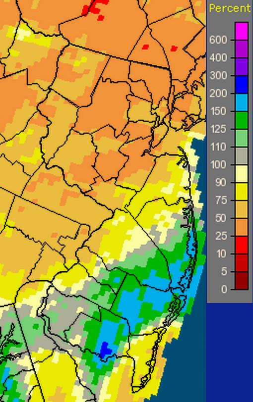
60-day Percent of Normal Precipitation ending September 30th. (Credit: National Weather Service's Advanced Hydrologic Prediction Service)
Overview
Combined with below-average precipitation in August, the northern half of New Jersey has become quite dry. Conversely, rainfall has been more common in the south, thus despite a drier-than-average September, the two-month total is slightly above average. Looking first at September, statewide precipitation averaged 2.82". This is 1.25" below the 1981-2010 average and ranks as the 46th driest September since 1895. From Hunterdon, Somerset, and Union counties northward, only 1.49" fell, which is 3.00" below average and ranks as 7th driest (Table 1). The southern counties averaged 3.47", which is 0.40" below average and ranks as 56th wettest.
|
Rank |
Year |
North Sept. Prcp |
|
1 |
1914 |
0.32" |
|
2 |
1941 |
0.46" |
|
3 |
1895 |
1.03" |
|
4 |
1948 |
1.03" |
|
5 |
2007 |
1.17" |
|
6 |
1898 |
1.39" |
|
7 |
2014 |
1.49" |
|
8 |
1964 |
1.59" |
|
9 |
1943 |
1.60" |
|
10 |
1980 |
1.69" |
Table 1. Ten driest Septembers in north Jersey since 1895.
The statewide August-September precipitation total was 7.22", which is 1.06" below average and ranks as 48th driest. Rendering these numbers regionally meaningless is the 3.52" two-month total in the north and 9.15" south total. Up north, this is 5.10" below average and ranks as 6th driest (Table 2). The south total is 0.98" above average and ranks as 52nd wettest. Northern totals are between 25%-50% of normal for the 60 days ending on September 30 (refer to the map above). Meanwhile, a substantial swath in the south receive from 100%-200% of normal, with the August 12-13 deluge in the vicinity of Millville (Cumberland) putting that small area above the 200% mark.
|
Rank |
Year |
North Aug.-Sept. Prcp |
|
1 |
1964 |
2.23" |
|
2 |
1914 |
2.99" |
|
3 |
1895 |
3.44" |
|
4 |
1980 |
3.46" |
|
4 |
2005 |
3.46" |
|
6 |
2014 |
3.52" |
|
7 |
1984 |
4.06" |
|
8 |
1953 |
4.24" |
|
9 |
1972 |
4.25" |
|
10 |
1916 |
4.62" |
Table 2. Ten driest August-Septembers in north Jersey since 1895.
September was above average in the temperature department. The mean of 67.0° was 0.8° above the 1981-2010 average and ranked as the 29th warmest on record (tied with 2 other months). It reversed the pattern of the last two months. Thus far, only May has had a warmer anomaly in 2014.
Precipitation and storms
September precipitation totals benefited from heavy rain that fell in south Jersey during the daytime of August 31st into the early hours of the 1st. As discussed in the August narrative, and similar to what occurred at the end of April, this rainfall is included in the September count. This resulted in maximum monthly totals of 7.92" in Winslow (Camden County), and in Gloucester County, Monroe Township 7.44", Clayton 7.33", Franklin Township 7.30", and Washington Township 6.74" and 5.86". If only rainfall from the 2nd through 30th is considered, Clayton tops the list with 4.55", followed by 4.26" in Monroe Township and 4.13" in Franklin Township.
The driest locations in NJ could not manage 1.00" for the month. This included North Brunswick (Middlesex) with only 0.89", Montgomery Township (Somerset) at 0.94" (with another station at 1.03"), South River (Middlesex) 0.97", Denville (Morris) 0.98", and Glen Rock (Bergen) 0.99".
August-September totals at individual stations were of course more striking than regional ones discussed previously. Ocean County had the three highest station totals with 16.11" in Lacey Township, 15.94" at Stafford Township, and 15.16" in Little Egg Harbor. Worrisome low totals include Denville (Morris) 2.02", Roxbury (Morris) 2.05", and Ringwood (Passaic) 2.36". As a result of the minimal rainfall in the north, streamflow at the end of September was near the lower third compared to normal, ground water levels had fallen below average, and reservoir levels recently fell below seasonal norms. The US Drought Monitor considers north Jersey to be in the D0 (abnormally dry) category.
Looking further at the August 31st-September 1st storm, the southwest portion of NJ over to the coast in southern Ocean County received more than an inch of rain. This included drenching totals of 4.32" and 3.15" at two locations in Washington Township (Gloucester), 4.21" in Winslow Township (Camden), 3.18" in Monroe Township (Gloucester), and 3.17" at Franklin Township (Gloucester). At most, a few tenths of an inch fell in north Jersey and in Cape May County.
The evening of the 2nd brought more rain to the southwest over to southern Burlington and Ocean counties. Winslow received 0.97", Clayton (Gloucester) 0.89", and Monroe Township 0.86". Nothing fell in north Jersey. There was some minor tree damage from winds in Camden County. Widely scattered showers fell in central NJ during the late afternoon and evening of the 5th. This included 1.32" in Cranbury (Middlesex), 0.61" at Berlin (Camden), and 0.45" in Woodbridge (Middlesex). More rain followed during the afternoon and evening of the 6th, accompanied by locally strong winds that brought down trees and power lines in portions of Monmouth and Burlington counties. Most everywhere in the state had a few tenths, with scattered half-inch totals in the northwest and south. Monmouth County received the most, with 1.88" in Red Bank, 1.64" at Freehold, and 1.39" in Rumson.
The second half of the 13th saw widespread 0.30"-0.60" totals in the southern third of the state, with 0.20"-0.30" common elsewhere. Top amounts included Long Hill Township (Morris) with 0.62", Woodstown (Salem) 0.54", and 0.53" in the Camden County communities of Winslow and Berlin. The morning of the 16th saw a moderate event in the northeast corner of the state deposit 0.84" in Summit (Union), 0.78" at Long Hill Township (Morris), 0.76" in North Arlington (Bergen), and 0.73" in Maplewood (Essex). A few tenths fell elsewhere in northern NJ, with little to none in the southern half of the state.
The final event of the month came later on the 24th into the 25th. A coastal storm brought over 1.50" to Cape May and nearby sections of Cumberland and Atlantic counties. Two dozen CoCoRaHS stations received over 2.00", 30 caught between 1.00"-1.99", 145 saw 0.01"-0.99", and Vernon Township (Sussex) did not receive any rain. Topping the list was Linwood (Atlantic) with 2.92", followed by Egg Harbor Township (Atlantic) 2.70", Stafford (Ocean) 2.67", and Franklin Township (Gloucester) 2.66".
The minimum barometric pressure of September occurred on the 21st, when many locations observed levels of 29.60"-29.65" of mercury. The 26th saw monthly maximums between 30.55"-30.60". On only 4 days during the month did a NJWxNet station report winds gusting to 40 mph or higher. These include a 41 mph gust at Harvey Cedars (Ocean) on the 2nd, Cream Ridge (Monmouth) 41 mph on the 6th, High Point Monument (Sussex) 42 mph on the 22nd, and Harvey Cedars 41 mph on the 25th.
Temperature
Following a summer with fewer-than-average days with maximum temperatures equaling or exceeding 90°, the first week of September saw one or more station achieve that mark on five afternoons. On the 1st, Hawthorne (Passaic) and Hillsborough (Somerset) topped out at 91°, with nine other stations within the 56 station NJWxNet at 90°. The 2nd saw 39 stations at 90° or higher, including Hawthorne at 95° and Jersey City (Hudson) at 94°. Hillsborough made it to 91° on the 4th and seven stations were at 90° or 91° on the 5th. The 6th was hottest day of the month and one of the three hottest days of the year (along with July 2nd and July 8th). The 90° mark was reached at 42 stations, with Hillsborough the hottest at 96°, followed by Hawthorne at 95° and five locations at 94°. Harvey Cedars (Ocean) only made it to 81° and Atlantic City Marina (Atlantic) to 84° on the 6th.
On 13 September days, Walpack (Sussex) had a low temperature of 45° or lower. Pequest (Warren) came close to this with 12. Looking at the seven mornings when the coldest conditions were found throughout NJ, all occurred from the 14th onwards. Seven stations were below 45° on the 14th, including Walpack at 41°. The first 30°s of the season were felt on the 15th, with Pequest down to 37°, Basking Ridge (Somerset) at 38°, and Walpack 39°. Basking Ridge again at 38° and Pequest at 39° led the way on the 17th, with both of these locations at 38° on the 18th.
The 22nd found Walpack down to 38° and Pequest at 41°. The 23rd had by far the coldest morning of the month. Walpack at 32° reported the first freezing temperature of the season. Pequest reached 35° and both Berkeley Township (Ocean) and Basking Ridge 36°. Some 48 NJWxNet stations dropped to 45° or lower, with Harvey Cedars the mildest in NJ at 52°. Walpack fell to 38° and Basking Ridge to 39° to complete the coolest mornings of September.


