February Overview
One of the more disruptive winters in recent decades continued during February, erasing the hopes of many for an early spring. Averaged across New Jersey, the monthly temperature of 29.5° was 4.3° below normal. This made for the 35th coldest February over the past 120 years and the coldest since 2007. Temperatures ranged from a low of -18° at Walpack in snow covered Sussex County valley on the 11th and 12th to a high of 67° at several southern locations on the 21st. The statewide average precipitation of 5.26" made for the 20th wettest February on record. This includes both rainfall and the liquid equivalent of frozen precipitation, and is 2.40" above normal. Snowfall averaged 21.9" across the state, which is 13.9" above normal and ranks as the 7th snowiest of the past 120 Februaries.
Precipitation and storms
Morris and Hunterdon counties received the most precipitation in February. Holland Township (Hunterdon County) totaled 6.81" of rain and melted snow/sleet. Close behind was Mine Hill (Morris) with 6.80", Stockton (Hunterdon) 6.75", and Rockaway (Morris) 6.63". The least precipitation was noted in Wantage (Sussex) at 3.85", New Providence (Union) 4.27", Hawthorne (Passaic) 4.38", and Saddle Brook (Bergen) 4.43".
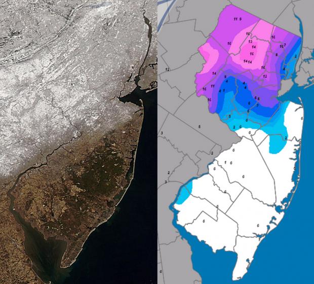
The aforementioned statewide snowfall average of 21.9" can be subdivided into a 31.2" average (+21.3") in the north (Warren-Morris-Essex counties northward), 28.3" (+19.5") in central NJ (Hunterdon-Mercer-Somerset-Union-Middlesex-Monmouth), and 15.6" (+9.1") in the remaining eight southern counties. The largest monthly total was 38.6" in both Holland Township (Hunterdon) and Jefferson Township (Morris). This was followed by 38.5" in Franklin Township (Hunterdon), Mine Hill (Morris) 38.3", Mendham (Morris) 37.4", and Cedar Grove (Essex) 37.0". Coastal southeast locations received much less snow, only totaling 3.7" at Egg Harbor Township (Atlantic), 4.1" in Little Egg Harbor (Ocean), 4.5" in Lacey Township (Ocean), and 5.7" at Woodbine (Cape May).
The first storm of the month began during the pre-dawn hours of the 3rd, just hours following the end of the Super Bowl game at MetLife Stadium in East Rutherford (Bergen County). Heavy, wet snow fell in the northern half of the state into the early evening, with melted equivalents as high as 1.54" in Stockton (Hunterdon), 1.51" at New Brunswick (Middlesex), and 1.50" in Franklin Township (Somerset). In the south, precipitation totals of about an inch, mainly in the form of rain, were common. Less than an inch of snow fell in south Jersey below I-195 and southeast of the NJ Turnpike. Snow increased rapidly to the north, exceeding 8.0" in most counties. Some of the larger totals in central and northeast counties included 11.0" in Lebanon (Hunterdon), 10.0" in Mine Hill, Glen Rock (Bergen) 9.8", Bedminster (Somerset) 9.5", Cheesequake (Middlesex) 9.5", Princeton (Mercer) 9.3", Cedar Grove (Essex) 9.0", and Freehold (Monmouth) 9.0".
Close on the heels of the first storm was a wetter and more chaotic storm beginning in the pre-dawn hours of the 5th and extending to early evening. Freezing rain accumulated on branches and power lines, some of which were still laden with wet snow from the storm on the 3rd. This resulted in power outages to over 100,000 customers, mainly in portions of west central NJ. Snow and sleet accumulations exceeded 5.0" north of Rt. 80, decreasing to about an inch in the Rt. 1 corridor. Little to no snow or sleet was seen south of there, while under an inch of rain fell further south. Montague (Sussex) took top snow honors with 11.4", followed by 11.0" in neighboring Wantage. The largest precipitation totals were observed in Bridgewater (Somerset) with 1.80", Stockton (Hunterdon) 1.78", Medford Lakes (Burlington) 1.75", and Lacey Township (Ocean) 1.74".
A small storm whitened the ground across NJ with 1.0"-3.0" of snow during the late afternoon and evening of the 9th. Largest totals included 3.0" at Ringoes (Hunterdon) and Moorestown (Burlington), and 2.8" in Brick (Ocean).
The largest snowstorm of the season, at least through February, occurred from late evening on the 12th to the pre-dawn hours of the 14th. This was mainly a snow event for the northwest, while elsewhere, a mix of snow, sleet, freezing rain, and rain fell over the course of the protracted event. All of the state began with snow, however after less than 2.0" fell a turnover to rain occurred near the coast south of Toms River (Ocean). Amounts increased west and north, with 10" or more accumulating in southwestern and central counties and more than 15" in counties north of I-78. The largest totals in nine northern counties included Montague (Sussex) 22.8", Blairstown (Warren) 19.1", Jefferson and Rockaway (Morris) 17.3", Cedar Grove (Essex) 17.1", Roselle (Union) 16.7", West Milford (Passaic) 16.3", Bedminster (Somerset) 16.0", Oakland (Bergen) 15.5", and Califon (Hunterdon) 15.1". Rain and melted frozen precipitation totaled as much as 3.17" in Holland (Hunterdon) and Bernards (Somerset) townships, 3.16" in Rockaway Township (Morris), and 2.89" in Lawrence Township (Mercer). The evening hours of the 13th brought a line of thunderstorms through the state, which included heavy rain, freezing rain, and/or sleet. Later in the evening, all precipitation returned to snow, depositing a final few inches.
A period of light to moderate snow deposited a few tenths of an inch of snow to over 3.0" across the state from late morning to early evening on the 15th. Some rain fell along the coast, where melted snow and rain totals were greatest. The Monmouth County communities of Red Bank, Ocean Township, Long Branch, and Freehold measured 0.45", 0.37", 0.34", and 0.34", respectively. Meanwhile, 4.9" of snow fell in Highland Lakes (Sussex), with 3.8" in Montague (Sussex) and Cheesequake (Middlesex).
The morning of the 18th saw a 3.0"-5.0" snowfall in southwestern counties, with 1.0"-3.0" elsewhere. Larger totals included Medford (Burlington) 5.0", Pittsgrove (Salem) 4.5", Winslow Township (Camden) 4.2", and South Harrison (Gloucester) 4.0". The highest precipitation totals were at Egg Harbor Township (Atlantic) 0.52", Upper Township and Woodbine (Cape May) 0.51", and Ewing (Mercer) and Wall (Monmouth) 0.49". With milder air in place on the 19th, rain fell in most places, though it began as a dusting to an inch of snow in northwest communities. As much as 0.50" of liquid fell in Rockaway (Morris) and West Milford (Passaic), 0.49" in Wantage (Sussex), and 0.45" in Berlin (Camden).
During the daylight hours of the 21st a warm front struggled to move north through the southern half of the state. Behind it, temperatures soared into the 60°s, while further north over snow covered central and northern NJ a dense fog set in and temperatures only made it to the low 40°s. Meanwhile a cold front was barreling down from the west. This all resulted in a strange mix of tornado and severe thunderstorm watches, and a dense fog advisory north of the front. Several central NJ counties were under all three while visibility was less than a quarter of a mile in fog and upwards of a foot of snow covered the ground. A squall line, replete with strong thunderstorms, crossed NJ during the late afternoon, dropping 0.67" of rain at Mine Hill (Morris), 0.60" in Rockaway Township (Morris), and 0.59" in Califon (Hunterdon).
A dusting up to 2.0" of snow in Randolph Township (Morris) on the morning of the 26th marked the end of a stormy month.
A rather remarkable swing in barometric pressure occurred from the 12th into the first portion of the 14th. Monthly high readings close to 30.60" were first observed, followed by February minimum values between 29.00" and 29.05" late in the interval.
As a mark of February's tumultuous meteorological behavior, at one or more locations winds gusted to at least 40 mph on 11 days. This began with a 40 mph gust at Wantage (Sussex) on the 6th, but it was not until mid month that the air began to flow rapidly across the state. The storm on the 13th, in the midst of the pressure plunge, brought 53 mph and 50 mph gusts to Harvey Cedars (Ocean) and Sea Girt (Monmouth), respectively. Eight other NJWxNet stations recorded gusts between 40 mph and 49 mph. The 14th brought a gust of 51 mph to Harvey Cedars, with six stations gusting between 41 mph and 44 mph. The high wind action next turned to the northwest hills where on the 15th High Point Monument (Sussex) gusted to 52 mph. The Monument station gusted to 50 mph on the 16th, when Wantage (Sussex) reached 45 mph. A day later, gusts at these two locations reached 46 mph and 44 mph, respectively. A 40 mph gust was observed at Seaside Heights (Ocean) on the 18th, with High Point Monument reaching 40 mph on the 19th and 20th. Cream Ridge (Monmouth) received a 47 mph gust during a thunderstorm on the 21st. The nine-day string of plus 40 mph gusts came to an end, however the Monument got back to a 41 mph gust on the 24th and reached 44 mph on the 27th, when Harvey Cedars, Woodbine (Cape May), and Seaside Heights made it to 42 mph, 40 mph and 40 mph, respectively.
Given the frequent and at times heavy nature of January and then February's snows, the ground remained snow covered across the northern half of NJ throughout the month. This marked only the 5th February in over a century that the National Weather Service Cooperative Station in New Brunswick (Middlesex) had an inch or more snow cover each day, and the first since 1978. At months end, snow cover ranged from 12"-15" deep in higher elevations of north Jersey to 6" within southern Hunterdon and Somerset and northern Middlesex counties. Within 20 miles to the south of this zone the cover quickly tapered off to just traces remaining on the ground.
As February ended, the liquid equivalent of the pack ranged from approximately 2.00" where a 6.0" snow cover was found to more than 4.00" where the depth exceeded 12.0". Concerns remained for potential flooding should the snow melt rapidly in March, particularly if accompanied by rain. The warm temperatures on the 22nd and 23rd reduced the snow pack in central NJ by over an inch of liquid equivalent and brought the Millstone River at Griggstown (Somerset) to minor flood stage. While not reducing the snow water equivalent as much further north, this melt episode removed enough snow from rooftops to lessen the threat of collapses. Structural failures, or concerns of such, prompted evacuations and temporary closures of scattered schools and commercial establishments, mainly those with flat roofs. Fortunately, most collapses were in abandoned structures and there were no reports of injuries.
Temperature
While below-average temperatures prevailed for much of the month, thermometers took several roller coaster rides. The first actually began on the last day of January as NJ climbed out of a very cold week. By the 1st, the 50° mark was reached at Red Lion (Burlington), Greenwich (Cumberland), and Cherry Hill (Camden). This mild air arrived in time for the Superbowl on the 2nd. On game day, Egg Harbor Township (Atlantic) and Oswego Lake (Burlington) topped out at 60°, 38 (of 54) NJWxNet stations reached 50°-59°, and the 16 remaining stations got to 43°- 49°. The 6:30 PM kickoff temperature at the Lyndhurst (Bergen) NJWxNet station, within a few miles of the stadium, was 47°, with a 1 mph wind blowing out of the NNW. By game's end the temperature was 42°. The wind at Lyndhurst never gusted higher than 14 mph during the game.
Following the 2nd, the temperature did not return to the 50° mark until the 18th, when Cape May Courthouse (Cape May) hit 53° and Woodbine (Cape May) 52°. High Point Monument only struggled to 30° on the 18th. The 19th saw West Cape May reach 59° and Cape May Courthouse 57°. Five stations topped out at 56° on the 20th. Before the aforementioned squall line crossed NJ on the 21st, Red Lion, Sewell (Gloucester), and Cherry Hill soared to 67°. Another 17 south Jersey stations made it into the 60°s and 14 into the 50°s. Meanwhile Hope (Warren) and Walpack (Sussex) only got to 40°. Toms River (Ocean) and Greenwich reached 61° on the 22nd. The last day of the mild spell on the 23rd saw Woodbine and Oswego Lake top out at 65°, twelve other stations in the 60°s, thirty-two in the 50°s, and High Point Monument the cool spot at 46°.
On eleven February days the temperature fell below zero at one or more NJ locations. Walpack (Sussex) was one of the stations on ten occasions. The 4th was the first subzero day, with Walpack and Pequest (Warren) both at -1°. Walpack fell to -4° on the 7th, with Pequest next coldest at 6°. This pattern continued the next two days with Walpack at -5° and -4° and Pequest at 3° and 5°, respectively. The 10th brought a -2° minimum to Kingwood (Hunterdon), with Walpack and Pequest at 1°. The coldest temperatures of the month occurred on the 11th and 12th when Walpack twice plummeted to -18°. Pequest and Kingwood reached -8° on the 11th and Pequest that same reading on the 12th. Four other stations were below zero on the 11th and eight others on the 12th. Meanwhile in the south, West Cape May only dropped to 20° on the 11th and Harvey Cedars to 15° on the 12th.
The 17th next saw Walpack drop below zero, reaching -3°, while Pequest was 4°. The last three days of the month brought a return to subzero conditions, with Walpack -3° and Kingwood 1° on the 26th, Walpack -6° and Kingwood -5° on the 27th, and Walpack -10° and High Point Monument -3° on the 28th. West Cape May at 13° experienced their coldest minimum of February on the 28th, yet it was the highest minimum in NJ.
Winter Overview
The 2013/14 winter (December through February) will go down as one of the more disruptive in New Jersey over the past several decades. It remains to be seen what the final snow tally for the entire snow season will be, however the 48.4" season-to-date statewide average snowfall through February ranked 6th greatest of the past 120 winters. Should not another flake fly in March (this is already not the case, following the March 3 south Jersey storm) this snow season would rank 9th greatest on record.
With all of the snow also came some rain storms. When all of the rain and melted snow is added up and averaged for the state the December-February total is 13.31”. This is 3.06” above the 1981-2010 normal and ranks as the 15th wettest winter on record. The top place is held by 1978/79 with 19.32”, with 2009/10, the most recent wetter winter, in third place with 16.56”.
The statewide average winter temperature was 30.7°. This is 2.8° below normal and ranks as the 34th coolest of the past 120 winters dating back to 1894/95. This ranking is likely surprising to many, the common belief being that this was one of the coldest winters on record. Clearly this is not the case, however there is some validity to people's assumption. It was New Jersey's third coldest winter since 1982. Only 1993/94 was colder at 29.0° (ranking 13th) and 2002/03 at 29.6° (ranking 21st). For those with longer memories, the following winters in the 1960s, 1970s and early 1980s were also were colder than the most recent one: 1961/62, 1962/63, 1968/69, 1969/70, 1976/77, 1977/78, 1978/79, 1980/81, and 1981/82. None, however, match the coldest NJ winter on record, which was 24.4° in 1917/18.


