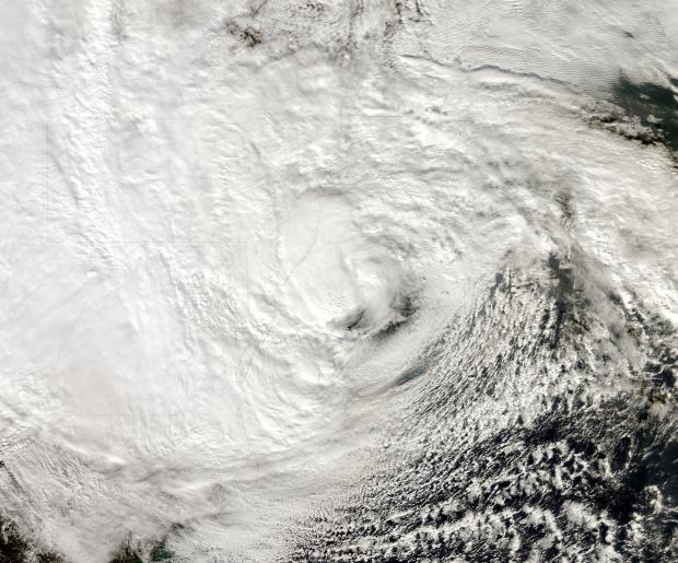
Sandy, a category 1 hurricane as it approached the New Jersey coast during the daytime hours of the 29th and a post-tropical cyclone as it came ashore near Atlantic City (Atlantic County) that evening, dealt the state a punishing blow. It brought hurricane-force wind gusts to coastal and inland sections, close to a foot of rain in the far south, a state record low barometric pressure, and a record storm surge along the coast and in adjacent water bodies. Additional information on Sandy can be found later in this report, and a more complete analysis will be provided on an upcoming website from the state climate office.
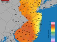
Statewide, the month averaged 57.1°, which is 2.3° above average. This ranks as the 20th warmest October since statewide records commenced in 1895. It marks the 21st consecutive month with temperatures equal to (June 2012) or warmer than (all other months since February 2011) average. The first ten months of this year have averaged 58.9°, or 3.1° above the 1981-2010 average. This keeps 2012 on pace to be the Garden State's warmest year on record (Table 1).
| Rank | Year | Jan-Oct Avg. Temp. |
|---|---|---|
| 1 | 2012 | 58.9° |
| 2 | 1998 | 58.2° |
| 2 | 2010 | 58.2° |
| 4 | 2002 | 58.0° |
| 5 | 1949 | 57.7° |
| 6 | 1991 | 57.3° |
| 7 | 2011 | 57.2° |
| 7 | 2006 | 57.2° |
| 9 | 1990 | 56.9° |
| 10 | 1953 | 56.8° |
Table 1. The ten warmest January to October intervals across New Jersey since 1895.
October started off with a warm week, particularly in the southern half of NJ. West Cape May (Cape May) reached 76° on the 2nd, with five other stations at 75°. The 2nd saw 17 of the 55 stations in the NJ Weather and Climate Network reach at least 80°, with Piney Hollow (Gloucester) taking top honors for the day and the month at 86°. Oswego Lake (Burlington) and Upper Deerfield (Cumberland) reached 85°, while High Point Monument (Sussex) was the cool spot at 67°. Dennis Township (Cape May) and West Cape May got to 80° on the 4th. The 5th was the warmest day of October across the state, as 27 stations reached the 80°s, with Mansfield (Burlington) on top at 83°. The warm spell ended on the 6th, with Upper Deerfield at 83° and Clayton (Gloucester) and Sicklerville (Camden) at 82°.
Red Lion (Burlington) and Clayton rose to 75° on the 14th, Toms River (Ocean) reached 76° on the 15th, and Piney Hollow 76° on the 19th, when seven other stations hit 75°. Piney Hollow reached 75° on the 23rd, while on the 24th Upper Deerfield was 80° and Greenwich (Salem) 79°.
The first freezing temperature of the season was observed at Basking Ridge (Somerset) on the 8th when the thermometer fell to 32°. In Sussex County, Walpack and High Point fell to 26° and 29°, respectively, on the 12th. The first widespread freeze of the season on the 13th came climatologically just about on time. Walpack chilled to 22° and Kingwood (Hunterdon) to 24°, and 19 other stations dropped to the freezing mark or below. Meanwhile, seven near-coastal stations remained between 50° and 57° that morning, the warmest being West Cape May. Walpack fell to 32° on the 16th, Pequest (Warren) and Basking Ridge to 28° on the 17th, and four stations dropped to 31° on the 18th. The last freeze of October occurred on the 22nd, when Walpack and Pequest each reached 31°, with no other station colder than 36°.
October was not a particularly windy month, at least until Sandy arrived! More on the big storm later, but on the 12th and 16th, gusts reached 43 mph at High Point Monument, marking the only plus 40 mph wind until the 28th. More on the lowest pressure later too, while the 13th brought the highest pressure of the month at approximately 30.50"-30.55".
Statewide October precipitation averaged 6.26". This is 2.33" above average and makes it the 14th wettest of the past 118 years. Cape May County and the northern Highlands were wettest, with Stone Harbor (14.92"), Wildwood Crest (13.53"), and Middle Township (12.96") tops in the south and West Milford (10.36") leading the north. 33 CoCoRaHS stations of the over 150 with complete or close to complete observations for rainy days (most missing daily reports were dry ones) had greater than 7.00" for the month, with 74 between 5.00" and 6.99". The east central and northeast areas were driest, with Bloomfield (Essex) receiving 3.04", two South Plainfield (Middlesex) stations at 3.32" and 3.54", and Woodbridge (Middlesex) at 3.69".
Six events during October dropped more than an inch of rain at one or more locations. The first storm occurred between middays on the 2nd and 3rd. Of the 225 CoCoRaHS reports, 15 exceeded 2.00", led by the northwest communities of Jefferson Township (Morris) with 2.97", and in Warren County, Oxford Township (2.93") and White Township (2.90").
The second half of the 4th brought as much as 1.15" to West Milford, 0.79" to Oakland (Bergen), and 0.70" to Hardyston (Sussex), but little south of I-80. The afternoon of the 9th to midday on the 10th saw coastal and east central areas receive 2.38" in Brick Township (Ocean) and 2.15" at Ocean Township (Monmouth), with little falling elsewhere. On the 15th, the region along and north of Route 1 and along the southeast coast received as much as 1.13" in Pennington (Mercer) and 0.84" in East Brunswick (Middlesex), with little elsewhere. The predawn hours of the 19th brought heavy rain to northwest NJ, followed by heavy midday rain in Somerset and Morris counties. Top amounts included 2.79" in Denville (Morris), 2.74" at West Milford, and 2.61" in Morris Township. Little fell south of Middlesex, Mercer, and northern Burlington counties.
As then Hurricane Sandy moved rather slowly to the northeast off the southeast US coast during the weekend of the 27th-28th, preparations were already underway along the Mid-Atlantic coast for a land falling storm late Monday the 29th or early on the 30th. As odd as it seemed, a storm appearing as if it was heading out into the north Atlantic was forecast to make a turn to the northwest and come ashore, bringing with it severe coastal flooding, strong winds at the coast and inland, and heavy rain with inland flooding. Of course, the consequences of such a storm on lives, property, transportation, communication, and the electric power grid were on the minds of emergency management officials, many stakeholders and the public, and preparations picked up in earnest.
The forecast was for Sandy to make landfall as a post-tropical cyclone, during a transition from a warm-core tropical system to a cold-core extratropical storm. Not that this nomenclature mattered too much, as it had become quite certain that this hybrid system was going to maintain a great deal of its hurricane strength, while blossoming in geographic extent. It took a unique combination of meteorological features to bring post-tropical cyclone Sandy onshore about 5 miles southwest of Atlantic City at around 8 PM EDT on the 29th. First was the tropical system that originated in the Caribbean Sea over a week earlier. While late in the season, Sandy developed in an area that was a climatologically common one for tropical storms at this time of year. So too was its track to the north over Jamaica, Cuba and Bahamas, with the slow turn to the northeast not uncommon. However the next ingredient to this potent recipe was climatologically unusual, that being a blocking high-pressure system sitting over the North Atlantic east of the Canadian Maritimes. The block, along with a central Atlantic area of low pressure, were both preventing Sandy's northeastward progress and suggested that the storm would turn and track to the northwest.
The 3rd ingredient was a vigorous early cold season dip in the jet stream, a trough that was advancing from central North America toward the East Coast. The system had been strong enough to deposit an unseasonable early season snow cover across the Canadian prairies. As the U-shaped trough began to approach the coast it felt the influence of the blocking high and began to assume a negative tilt, with the central axis of this inverted trough angled back to the northwest. This placed the energetic jet stream near advancing Sandy and also helped pull the storm toward the coast. Such was the case that the NJ coast was in the cross hairs of this rogue storm. Adding insult to injury was the arrival of the storm when the moon was full, thus tides astronomically high. Also, as fate would have it, the storm made landfall close to high tide on the evening of the 29th.
The result was a storm that caused damage that equaled or surpassed the worst coastal battering on record. The storm surge along the northern coast exceeded the previous record at Sandy Hook by over 3 feet. Sandy falls alongside the nor'easter of March 1962 and the hurricane of September 1944 as NJ's most destructive coastal storms of the past century. It is likely that inland winds had never been as strong or of a multi-hour duration in the modern era across central and northern areas; perhaps not since an 1821 hurricane ravaged the region. While precipitation was not excessive over most of the state, the far southern coastal region had a deluge that statistically happens once every 200 years.
The result of Sandy's rampage was devastation to homes and infrastructure along portions of the northern and central coast, thousands of trees falling on homes, automobiles, and power lines across the state, leading to unprecedented damage to the power grid, the loss of power to over 75% of customers, and record disruptions of transportation and communications. Of course all of this pales in comparison to the tragic loss of approximately two dozen lives, the result of falling trees, floodwaters, and other storm-related causes.
While meteorological numbers do not begin to tell the entire story of Sandy, it is worthwhile to document a few. In terms of rainfall, Cape May County took top honors. From the morning of the 28th through the early afternoon of the 30th, Stone Harbor led the way with 12.71", followed by 11.91" and 11.70" at two Wildwood Crest locations, 9.53" in West Cape May, 8.97" at Dennis Township, and 8.41" in Lower Township. Totals fell off to the north, with some Bergen County locations receiving less than 1.00", including Oakland (0.75"), Tenafly (0.83"), and North Arlington (0.84"). Of the over 100 rainfall reports from around NJ, seven were between 7.00-7.99", eight from 5.00-5.99", and ten from 4.00-4.99".
The National Hurricane Center reported a pressure reading of 27.94" at landfall. This equals the lowest pressure of any system coming ashore north of Cape Hatteras on the Atlantic coast, which was first observed during the devastating and deadly 1938 Long Island/New England hurricane. The lowest pressure observed at a station was 27.98" at the Atlantic City Marina, followed by 28.00" at the NWS Atlantic City Airport station in Pomona. Whichever value to be deemed lowest for Sandy greatly surpasses the previous state record minimum pressure, which was 28.36" in Long Branch (Monmouth) during a nor'easter on March 6, 1932. In fact, during the evening of the 29th, all of southern NJ exceeded the previous record.
One of the more vexing issues in the post-Sandy analysis is determining how fast sustained winds (averaged over at least a minute) and gusts (generally considered 2 second observations) reached during the storm. Issues to consider when evaluating an observation include instrumentation characteristics and location. There are a variety of anemometers deployed at stations around NJ, most of which have not been subject to calibration since they were installed, which in some cases is a number of years ago. Thus one should immediately be suspicious of observations that greatly exceed others in a given area. Anemometer siting is a major issue, as widely exposed or highly elevated instruments will record winds of greater intensity than those in more sheltered locations. Anemometers mounted 10 feet off the ground will tend to have lower gusts than those at 30 feet, and there may be enhancement of winds due to the funneling effects provided by structures when instruments are placed on a rooftop or between buildings. The ONJSC continues to evaluate all Sandy wind reports, and at this point can only report with some confidence that sustained winds were well over tropical storm force (39 mph) at coastal locations and at exposed inland locations in northern and central NJ. Gusts exceeded hurricane force (74 mph) at many coastal locations and at some exposed inland sites.
Within the NJ Weather and Climate Network (NJWxNet), Sea Girt (Monmouth) and High Point Monument (Sussex) had top gusts of 79 mph on the 29th. Five other NJWxNet stations gusted over 70 mph, nine between 60-69 mph, ten from 50-59 mph, and 17 from 40-49 mph. The lowest gust was 26 mph atop a 10-foot tripod at Cherry Hill (Camden). This site is in a wooded park at this southwest NJ location, the area of NJ where Sandy's winds were least strong. Other wind observations that were measured with quality instruments in well-situated locations include gusts as high as 88 mph at Tuckerton (Ocean) and 87 mph at Sandy Hook (Monmouth). Airport stations at Newark (Essex), Sussex (Sussex), Teterboro (Bergen), Lakehurst (Ocean), and Caldwell (Essex) achieved maximum gusts between 70 and 78 mph. As Sandy approached on the 28th, Harvey Cedars (Ocean) gusted to 49 mph, and as she departed early on the 30th High Point Monument reached 64 mph, Sea Girt 61 mph, and Wantage (Sussex) 60 mph.
That Sandy arrived on the same day as last year's record shattering October snowstorm in central and northern NJ adds a sobering and quite remarkable footnote to the events surrounding October 29, 2012.


