Fall

Summer is Slow to End: September 2016 Recap

October 5, 2016 - 4:25pm -- Dave Robinson

Sunrise photo

Summer warmth continued into September, only beginning to relinquish its grip on the Garden State during the last week of the month. The average statewide monthly temperature of 70.1° was 4.3° above the 1981–2010 mean. This ranks as the 4th warmest September going back to 1895, with five of the eight warmest Septembers occurring since 2005. Seven of the most recent 13 months have ranked in the top 10 for warmth in their respective months.

Monthly rainfall averaged 3.36” across the state, which is 0.69” below average and ranks as the 61st driest of the past 122 Septembers. However, as discussed below, the average this month does not show the wide disparity of rainfall between the northern and southern parts of the state. While concerns for persistent dry conditions continued increasing across most of NJ through mid September, two soakings in the south alleviated worries in this region. Meanwhile, only one event of note produced totals exceeding an inch in much of the north, thus this region remains much too dry. As of the 27th, a good deal of north and central NJ was considered in moderate drought, with the remainder deemed abnormally dry according to the US Drought Monitor. North Jersey remained under a NJ Department of Environmental Protection “drought watch."

Unseasonably Mild and Dry: November and Fall 2015 Recaps

December 4, 2015 - 4:11pm -- Dave Robinson

Sunset picture

The climatological fall season ended on a mild note, with the statewide November average temperature of 49.3° coming in at 3.7° above normal. This ranks as the 5th mildest November on record, tied with 1948. Observations go back 121 years to 1895, yet five of the nine warmest Novembers have occurred since 2001. The month had an abundance of sunny days, during what is commonly a rather cloudy time of the year. Precipitation averaged 2.33” across NJ, which is 1.31” below normal and ranks as the 41st driest November. Only two significant rain events occurred during the mid-month interval.

On Average, Rather Average, Bookended by Stormy Conditions: October 2015 Recap

November 6, 2015 - 4:58pm -- Dave Robinson

Waves picture

There were many sides to New Jersey’s October 2015 weather, however, when temperature and rainfall observations were averaged, conditions were quite close to long-term (1981–2010) means. The statewide average temperature of 54.4° was 0.4° below normal. This ranked as the 53rd coolest since 1895 (121 years). Precipitation averaged 4.17", which is 0.24" above normal and ranks as 44th wettest. October was bookended by events that dumped the vast majority of the month’s precipitation, with an extended period of very dry weather in between. This led to a continuation of moderate drought in the northeast, with nearby areas remaining abnormally dry. The late-month rain, which for the first time in many months was heaviest over the driest areas, staved off the need for any further drought deterioration, at least for the time being. The major weather event of the month extended over the first five days, when incessant onshore winds generated the worst beach erosion and back bay flooding since Sandy three years ago, though not nearly in the same ballpark of what Sandy wrought.

A Cool Damp Month, and All Things Considered, a Rather Average Season: November and Fall 2014 Recap

December 7, 2014 - 7:32pm -- Dave Robinson

Wantage snow Nov 27

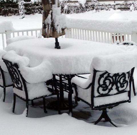
While cooler conditions took some time to arrive in New Jersey this fall, once here they locked in for the most part, as the November average temperature of 41.9° was 3.7° below the 1981-2010 average. This ranks as the 24th coolest November of the past 120 years. November precipitation (rain and melted snow) averaged 4.58" across the state. This is 0.94" above average and ranks as 31st wettest. On two occasions measurable snow was reported in northern and central areas, with these regions, respectively, picking up 4.6" and 1.9" on average for the month, with over a foot accumulating at higher elevations. Despite no snow accumulating in the south, the statewide average was 1.7", which is 1.3" above average. It is only the second November to average above an inch since 1995, the other in 2012. A Thanksgiving eve storm delivered a white Thanksgiving to central and northern counties.

El Niño Potential: Fall Impacts

October 15, 2014 - 10:12pm -- Jack McCarty

Sea Surface Temperature Anomalies

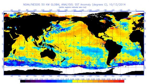
Early this past summer, we reported on the potential impacts of a developing El Niño event in the tropical Pacific on summertime weather in New Jersey. While El Niños can impact the weather worldwide, we found that New Jersey's weather doesn't fluctuate with an El Niño event. This year's summer (June-August) proved to be rather comfortable, with the statewide average temperature 0.8° below the 1981-2010 average , and precipitation 0.26” above the 1981-2010 average. These mild conditions replicated what we expect out of an El Niño summer. Now we’re back to tell you the story for the fall.

Pages

Subscribe to RSS - Fall