Overview
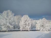
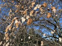
If you think it has been a long time since New Jersey experienced as chilly an April as this past one, you are correct. With snow accumulating in a storm on the 2nd to snow showers on the 30th, one was hard pressed to find many days when pleasant spring conditions could be found. Toss in two mid-month days when temperatures soared into the middle 80°s and another with strong thunderstorms delivering flash flood-producing rains, and weather-oriented heads kept spinning. However, overall, it was the persistent chill that captured the most attention, with the green up of lawns and foliage, accompanied by the blossoming of spring flowers, delayed from normal by upwards of two weeks.
Statewide, the April average temperature of 47.7° was 3.2° below the 1981–2010 mean (2.0° below the 1895–2017 mean). This ranks as the 28th coolest April since 1895 and the chilliest since 1982 (also 47.7°). The highest temperature observed in NJ was 87° at Stewartsville (Warren County) on the 14th and the coldest 16° at Walpack (Sussex) on the 11th.
April precipitation across NJ averaged 4.20”. This was 0.21” above the 1981–2010 mean (0.48” above the period-of-record mean). This was the 38th wettest April on record. Plentiful precipitation since February has eliminated drought concerns as we enter the summer water consumption season. Reservoirs and ground water levels are in good shape. However, this never means we should let our guard down and not use water in a responsible manner.
April snowfall averaged 2.4” across NJ, which was 1.6” above the period-of-record mean. It was the snowiest April since 2003 and ranks as the 13th snowiest since 1895. The most snow fell in the north, with an average of 5.9” (+4.8”). The central region caught 3.5” (+2.6”), while the south did not see accumulating snow (-0.5”). Statewide, the 2017/2018 snow season came in with 39.8”. This is 13.7” above average and the 17th snowiest season on record. The north averaged 57.1” (+22.3, 15th snowiest), central 41.5” (+12.5, 21st snowiest), and south 29.8” (+9.8”, 22nd snowiest). For the state and all regions, this was the snowiest season since 2013/14.
Temperature
There were nine April days when the high temperature equaled or exceeded 70° at one or more NJWxNet stations and seven days with the maximum between 65°–69°. The lowest daily maximum of the month was 33° at High Point Monument (HPM; Sussex) on the 3rd. The first 70° day of the month was the 4th, with Oswego Lake (Burlington) up to 75° and 73° at four stations (of 63 NJWxNet stations). Meanwhile, HPM only reached 48°. The warmest spell of the month began on the 12th, with Logan Township (Gloucester) and Vineland (Cumberland) at 73° and 26 stations between 70°–72°. Temperatures soared on the 13th, with Sicklerville (Camden) reaching 86°, 11 stations at 85°, and 39 stations between 80°–84°. With the cool ocean and bay waters nearby, Harvey Cedars (Ocean) and Atlantic City Marina (ACM; Atlantic) only rose to 60° and 62°, respectively. It was even warmer on the 14th, with Stewartsville roasting at 87°, Basking Ridge (Somerset), Hamilton (Mercer), Howell (Monmouth), and Pequest (Warren) all at 86°, and 41 locations between 80°–85°. Harvey Cedars only reached 57° and ACM 60°. There was an interesting divergence in the diurnal temperature range on the 14th between coastal ACM with an 8° swing (60°–52°) while, just a few miles inland, Howell had a 42° range (86°–44°).
The thermometer did not rise again to 70° until Wayne (Passaic) achieved that mark on the 22nd. That day, Walpack had an impressive 45° diurnal range from a morning minimum of 22° to a maximum of 67°. The 23rd found west central Jersey warmth at Mansfield (Burlington), Cherry Hill (Camden), Sicklerville, Hamilton (Mercer), and Red Lion (Burlington), with all reaching 72°. Vineland, Hammonton (Atlantic), and Piney Hollow (Gloucester) all hit 74° on the 25th. Wayne got to 71° and seven stations 70° on the 26th. A warm 28th found Sicklerville and West Deptford (Gloucester) at 77° and 43 stations between 70°–76°.
On twelve April days, the minimum temperature fell to 25° at one or more NJWxNet station. This included nine of the first eleven days of the month and from the 21st–23rd. There were eleven other days when a location fell below freezing, leaving only seven April days where no location froze. The mildest of these was the 13th, when Pequest was coolest at 43°. The first 25° or colder day was the 2nd, with HPM at 24° and High Point (Sussex) 25°. Berkeley Township (Ocean) was coldest at 23° on the 3rd. Walpack and HPM fell to 22 on the 5th, Walpack was 22° and High Point 23° on the 6th, and Walpack and HPM 25° on the 7th.
The teens were reached on the 8th, with Walpack at 17° and HPM 18°. This occurred again on the 9th, with Berkeley Township 18°, Walpack 19°, and 17 stations between 20°–25°. Walpack was 23° and Pequest 24° on the 10th. The 11th essentially matched the 9th for coldest morning of the month, with Walpack 16°, Pequest 18°, Berkeley Township 19°, and 17 stations between 20°–25°. Later in the month, Walpack fell to 21°, Pequest 23°, and Berkeley Township 25° on the 21st. Walpack dropped to 22° and Pequest 25° on the 22nd, and Walpack was 24° on the 23rd. Freezes occurred through the 30th, when HPM fell to 31° and High Point 32°.
Precipitation and Storms
North Jersey saw the most April precipitation (rain and melted snow), especially the northeast, where two Hawthorne (Passaic) stations caught 8.19” and 7.93”, Little Falls (Passaic) 7.75”, Rockaway (Morris) 6.76”, Chatham (Morris) 6.75”, and Palisades Park (Bergen) 6.73”. The Burlington-Ocean county region saw the lowest totals, with two Jackson Township (Ocean) stations at 2.61” and 2.99”, Woodland Township (Burlington) 2.66”, and Hainesport (Burlington) 2.98”. The bulk of the snow fell in the April 2nd event, leading to the top totals for the month being 8.4” in Cedar Grove (Essex), followed by 7.7” at the High Point Ranger Station (Sussex), 7.5” in West Caldwell (Essex) and Peapack-Gladstone (Somerset), and 7.4” in Tenafly (Bergen), Parsippany-Troy Hills (Morris), Little Falls, and Hawthorne.
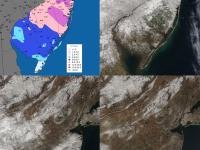
Two storms took the spotlight during April, one for its snow and the other for its flood-generating rain. One other event delivered inch-plus rain to a portion of NJ, while a few others brought as much as a half-inch. A quick-hitting late-season snowstorm started things off on the morning of the 2nd. Snow fell heavily across the northern half of the state, with just a few tenths of an inch of rain falling in the south. Twelve counties saw one or more locations collect at least 3.0” of snow (Table 1, Figure 1). Cedar Grove led the way with 8.2”, with 7.0”–7.5” totals in communities in six other counties. The largest precipitation totals (melted snow) were in Parsippany-Troy Hills with 0.76”, and North Arlington (Bergen), Hawthorne, and Washington Township (Morris) each with 0.74”.
| County | Location | Snowfall |
|---|---|---|
| Bergen | Tenafly | 7.4” |
| Essex | Cedar Grove | 8.2” |
| Hudson | Kearny | 6.8” |
| Hunterdon | Bethlehem Township | 7.0” |
| Middlesex | Woodbridge | 3.4” |
| Monmouth | Colts Neck | 3.0” |
| Morris | Green Pond | 7.3” |
| Passaic | Little Falls | 7.4” |
| Somerset | Peapack-Gladstone | 7.5” |
| Sussex | Highland Lakes | 7.4” |
| Union | New Providence | 6.0” |
| Warren | Allamuchy, Blairstown, Hackettstown, & White Township | 6.0” |
Table 1. Largest snowfall in the 12 NJ counties where totals on April 2nd equaled or exceeded 3.0” at one or more locations.
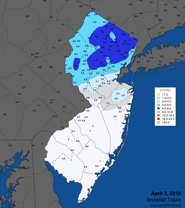
Figure 1. Snowfall totals for April 2nd.
Rain showers on the 3rd were accompanied by thunder in some locations. The heaviest totals were in the north, with under 0.20” further south. Sussex (Sussex) received 0.77”, Vernon Township (Sussex) 0.68”, West Milford (Passaic) 0.62”, and Franklin (Sussex) 0.61”. Daytime showers returned on the 4th in the southeast, with two Estell Manor (Atlantic) stations recording 0.49” and 0.34” and Port Republic (Atlantic) 0.33”.
All was quiet until cloudy, drizzly conditions on the 15th transitioned into moderate to heavy rain from south to north during the evening into the early morning hours of the 16th. There was even some freezing rain and sleet at the outset in higher northern elevations. The heavy morning rain on the 16th was accompanied by strong winds and thunderstorms. Some damage from lightning strikes occurred in several locations. Everywhere received a soaking of over an inch (Figure 2), with the largest amounts in the northeast, including Westwood (Bergen) with 4.48”, Palisades Park 4.23”, River Vale (Bergen) 4.17”, Woodbridge (Middlesex) 4.14”, and Harrison (Hudson) 4.05”. Thirty CoCoRaHS stations caught from 3.00”–3.99”, 52 from 2.50”–2.99”, 72 from 2.00”–2.49”, and 47 from 1.15” (Jackson Township) to 1.99”. The morning downpour resulted in flash flooding of streams and numerous roadways. Storm runoff brought some rivers to low to moderate flood stages, and a few to levels seen only once every 3 to 4 years.
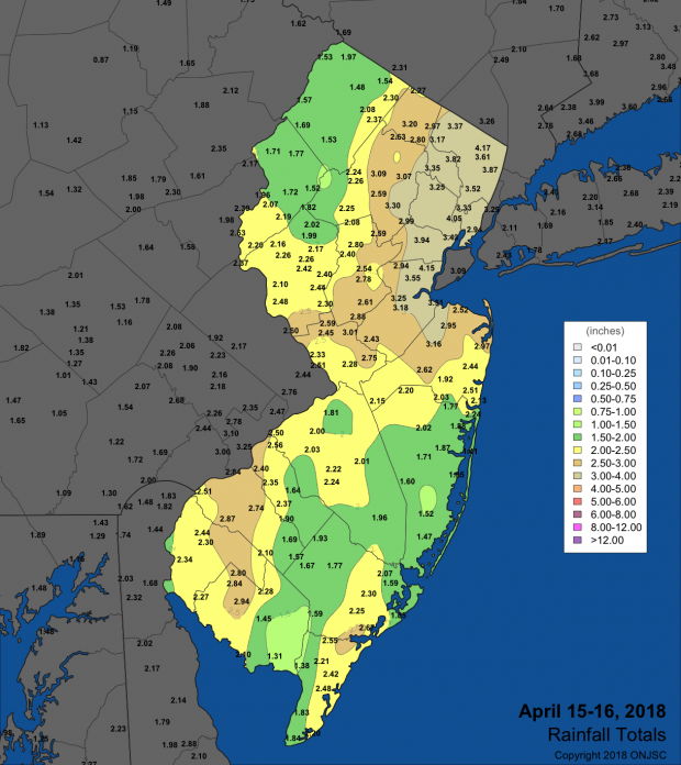
Figure 2. Rainfall totals for April 15th-16th.
A swath of rain crossed northern NJ in the predawn hours of the 19th. A few tenths of an inch of snow mixed in at higher elevations. Modest rainfall totals of 0.53” were found at River Vale, 0.48” in Hawthorne, 0.44” to Glen Rock (Bergen), and 0.43” at Glen Gardner (Hunterdon).
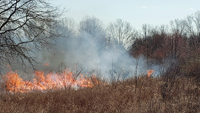
Despite the heavy rains a week earlier, a forest fire erupted in the Penn State Forest (Burlington) on the 22nd. Before being mostly contained by midday on the 23rd, over 800 acres burned. Fortunately, there were no injuries reported nor any buildings damaged.
Off and on rain plagued all portions of the state from the evening of the 24th until early on the 26th. Hawthorne received 2.90”, Southampton (Burlington) 2.28”, and two Little Falls stations 2.13” and 1.92”. Twenty eight other locations saw 1.00”–1.99”, with the remainder of the 212 CoCoRaHS reporting sites catching under an inch.
A few tenths of an inch of rain fell, mainly in the south, early on the 27th. More widespread showers followed during the evening of the 28th into the predawn hours of the 29th. Most locations received several tenths, with Little Falls catching the most with 0.58”, followed by 0.55” in West Caldwell (Essex) and six Franklin Township (Somerset) stations coming in with 0.55”, 0.52”, 0.52”, 0.50”, 0.49” and 0.41”. Thunder was heard with the showers in some northern locations.
While long-term records at higher elevations in northern NJ are unavailable, it is certainly a rare April when snowfall is observed on ten days even at those heights. Such was the case this month, with both the High Point Ranger Station and Wantage (Sussex) at 1020’ meeting that mark. Each location saw flakes flying on the 2nd, 6th, 10th, 15th, 16th, 17th, 18th, 19th, 20th, and 30th. The snow was measureable on six of those days at the Ranger station (7.7” total) and five at Wantage (7.1” total).
The highest barometric pressure in April was in the 30.45”¬–30.50” range on the 23rd. The lowest pressure was about 29.40” on the 16th. Winds gusted to 40 mph or higher at one or more NJWxNet locations on nine April days. It must be noted that the windiest NJWxNet anemometer at High Point Monument was damaged by ice on the 16th and awaits repair. Fortescue (Cumberland) had a gust of 41 mph on the 3rd. The 4th was an exceptionally windy day, with gusts at eight stations equaling or exceeding 50 mph and 21 stations gusting between 40 mph–49 mph. HPM reached 59 mph, Pennsauken and Seaside Heights (Ocean) 55 mph, Logan Township 52 mph, and Fortescue, Harvey Cedars (Ocean), Pittstown (Hunterdon), and Sea Girt (Monmouth) reaching 50 mph. As winds slowly subsided on the 5th, HPM still reached 61 mph, Pennsauken (Camden) 48 mph, Fortescue 46 mph, Seaside Heights 44 mph, and Sea Girt 41 mph.
A gusty mid-month interval began with a 40 mph reading at Seaside Heights on the 12th and 41 mph at Harvey Cedars on the 13th. The 15th found Fortescue and Sea Girt gusting to 44 mph, Seaside Heights 43 mph, and seven stations between 40 mph–42 mph. Mullica (Atlantic) reached 48 mph on the 16th, with Berkeley Township and Sea Girt at 47 mph and six stations between 40 mph–42 mph. Fortescue hit 40 mph on the 19th. Calmer conditions prevailed later in the month, though Stewartsville gusted to 44 mph during an evening squall on the 28th.


