May Overview
Weather often varies from week-to-week and even day-to-day during the spring transition season. Such was certainly the case in spring 2021, as will be recapped later in this report. However, when it came to such “weather indecision,” May 2021 took the cake. Starting off somewhat damp with seasonable temperatures, a prolonged period of exceedingly dry weather ensued, first accompanied by cooler-than-normal temperatures and frosty mornings, and later by summer-like heat. As several wildfires broke out and soil moisture vanished, concerns of early-summer drought arose. Then along came one of the coolest Memorial Day weekends on record, accompanied by more than an average May’s worth of rain in some locations. This led to frequent decision making amongst farmers, gardeners, water resource managers, utility companies and customers, and day trippers. All were left wondering what might come next! Cicadas perhaps?
With the thermometer up and down throughout May, the statewide average temperature of 61.0° was just 0.2° below the new 1991–2020 normal. This ranked as the 47th mildest May since 1895. The average maximum of 73.0° was 0.7° above normal, while the 49.0° average minimum was 1.2° below normal. This is illustrative of a month that had many clear days and cool nights with low humidity. Despite dry conditions for most of the month, monthly precipitation came in close to normal, averaging 3.95” across NJ. This is 0.20” above normal, ranking 48th wettest of the past 127 years. Far south and west central areas were driest, while the central coast and northeast saw the most rain (Figure 1). Unlike last May, no snow was observed.
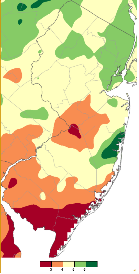
Figure 1. May 2021 precipitation across New Jersey based on a PRISM (Oregon State University) analysis generated using NWS Cooperative and CoCoRaHS observations from 7 AM on April 30th to 7 AM on May 31st. Note the scale in inches at the bottom of the figure. Totals range from 2.00”-3.00” (red) to 6.00”–7.00” (dark green).
Precipitation and Storms
The wettest location in the state in May was Brick Township (Ocean County), where three CoCoRaHS observers recorded 7.32”, 7.08”, and 6.84”. Elsewhere in northern coastal Ocean County, Pine Beach caught 6.71”, Point Pleasant Beach 6.55”, Lacey Township 6.54”, and two Toms River locations 6.31” and 6.13”. Elsewhere, Mt. Arlington (Morris) saw 6.22” and Cedar Grove (Essex) 6.17”. Long Beach Township in southern Ocean County received the least May rainfall with just 1.50”. This was followed by Ocean City (Cape May) at 2.32”, three Woodbine (Cape May) stations with 2.46”, 2.48”, and 2.72”, Lower Township (Cape May) 2.49”, and in Atlantic County, Hamilton Township with 2.62”, Somers Point 2.71”, and Galloway Township and Estell Manor each with 2.73”.
The first rainfall of the month began during the afternoon of the 3rd, tapering off before dawn on the 4th. This brought 1.12” to Tenafly (Bergen), Montague (Sussex) 1.06”, Woodbridge (Middlesex) 0.98”, and Bergenfield (Bergen) 0.97” (Figure 2). Of the 256 CoCoRaHS reports, 95 were between 0.50”–0.99”.
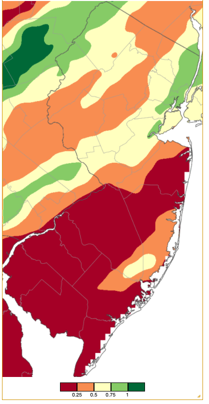
Figure 2. Rainfall from approximately 7 AM on May 3rd to 7 AM on May 4th based on a PRISM (Oregon State University) analysis generated using NWS Cooperative and CoCoRaHS observations. Note the scale in inches at the bottom of the figure.
Rain resumed during the daytime hours of the 5th, bringing 0.65” to White Township (Warren), Clinton (Hunterdon) 0.61”, and Oxford (Warren) 0.59”. Nine locations saw 0.51”–0.58”.
Rain from late on the 7th into the morning of the 8th brought local totals of as much as 1.18” to Haddon Heights (Camden), Pennsauken (Camden) 0.71”, Knowlton Township (Warren) 0.70”, Kingwood (Hunterdon) 0.67”, and Mt. Ephraim (Camden) 0.65”. Fast-moving squally lines of showers and thunderstorms during the afternoon of the 8th covered the ground with hail in Randolph (Morris) and spawned a waterspout in Barnegat Bay near Seaside Heights (Ocean). Hail from pea to ¾” diameter was observed in eight counties. Rainfall totaled 0.86” in Woodbridge, Livingston (Essex) 0.82”, and Colts Neck (Monmouth) 0.78”. Sixteen CoCoRaHS locations saw from 0.50”–0.66”. Northern areas caught some rain early on the 10th, amounting to 0.77” in both Montague and Wantage (Sussex), and 0.79” and 0.71” at two Vernon Township (Sussex) locations.
Aside from a few widely-scattered showers on the 15th, little to no rain fell across New Jersey from the 11th through the 25th. Sunny skies and low humidity quickly dried out vegetation and soil. As a result, a 600-acre fire in Bass River State Forest (Ocean) burned from the 16th–17th, and an over 400-acre fire occurred in Brendan Byrne State Forest (Burlington) on the 17th–18th. No injuries or significant structural damage was reported in either fire, though homes were threatened.
The increasingly dry conditions led to the entire state being placed into the Abnormally Dry category (D0) on the May 27th National Drought Monitor (NDM) map. A D0 rating is representative of dry conditions over a period of at least several weeks that occurs approximately every three to five years. It functions as a heads up, if you will, of potential drought conditions that may be on the way.
The NDM map is based on conditions through midday two days before its weekly release and does not consider forecasts of impending rain, or for that matter, continued dry conditions. Thus, the lines of thunderstorms that brought substantial rain to portions of the state during the late afternoon and evening of the 26th were not factored into the 27th map report. These storms brought as much as 2.09” and 2.07” to two Pine Beach gauges, 1.98” and 1.33” at two Toms River sites, Berkeley Township (Ocean) 1.82”, Brick 1.62” and 1.49”, Moorestown (Burlington) 1.61” and 1.52”, and Lacey Township 1.55” (Figure 3). Sixteen of the 254 CoCoRaHS reports came in between 1.00”–1.49”, and 85 from 0.50”–0.99”. All but five reports totaled more than 0.10”. Pea size hail was observed in Atlantic County. Strong winds brought down trees and wires during a 5:00–8:00 PM squall line in the north and a 10:00–midnight line in the mid-south. Peak gusts recorded at NJWxNet stations included 59 mph at Seaside Heights, Lower Alloways Creek Township (Salem) 55 mph, Moorestown 50 mph, Hillsborough-Duke (Somerset) 49 mph, Upper Deerfield (Cumberland) 47 mph, and four stations from 40–45 mph.
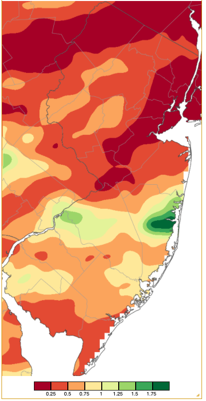
Figure 3. Rainfall from approximately 7 AM on May 26th to 7 AM on May 27th based on a PRISM (Oregon State University) analysis generated using NWS Cooperative and CoCoRaHS observations. Note the scale in inches at the bottom of the figure.
While the rains of the 26th put a dent in the dry conditions, for most areas it represented less than a normal May week’s worth of rain. Clearly more would be needed to greatly relieve increasing drought worries. Just such rain arrived on Friday afternoon the 28th, ending by the evening of Sunday the 30th. The steadiest rain fell from the evening of the 28th through the afternoon of the 29th and again from early on the 30th into the afternoon. Drizzle often occurred at other times. Unfortunately timed to coincide with the Memorial Day weekend and accompanied by unseasonably cool temperatures (see next section), the rain nonetheless significantly reduced drought concerns. The June 3rd NDM map showed D0 just in the far south and a small portion of the northwest.
Precipitation totals for the multi-day event ran as high as 4.74”, 4.70”, and 4.46” at three Brick locations, Point Pleasant Beach 4.51”, Lacey Township 4.41”, Washington Township (Gloucester) 4.27”, Toms River 4.16” and 3.73”, and Pine Beach 4.09” (Figure 4). Of 253 CoCoRaHS reports, 52 were from 3.00”–3.99”, 145 from 2.00”–2.99”, and 47 from 1.00”–1.99”. Long Beach Township saw the least rain but still managed to pick up 0.88”. The storm brought strong easterly winds that resulted in some minor to borderline moderate coastal flooding. Peak gusts on the 28th were 43 mph at Seaside Heights and 40 mph in both Sea Girt (Monmouth) and Atlantic City Marina (Atlantic). Gusts on the 29th reached 50 mph at Harvey Cedars (Ocean), Seaside Heights 49 mph, Sea Girt 45 mph, Atlantic City Marina 44 mph, and Berkeley Township 41 mph.
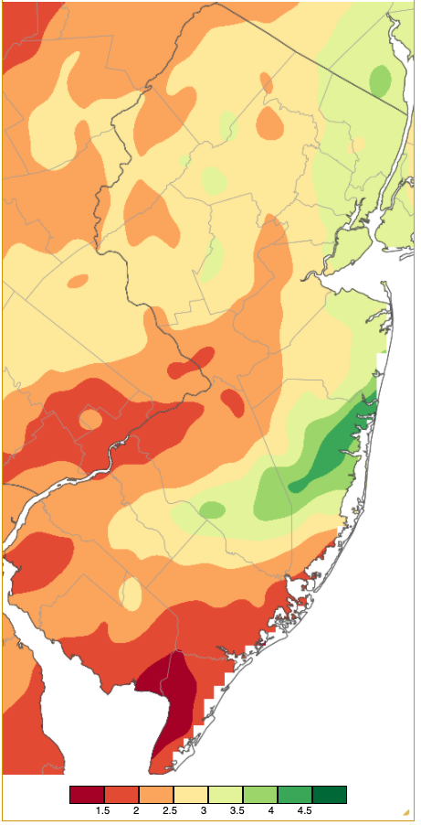
Figure 4. Rainfall from approximately 7 AM on May 28th to 7 AM on May 31st based on a PRISM (Oregon State University) analysis generated using NWS Cooperative and CoCoRaHS observations. Note the scale in inches at the bottom of the figure.
The lowest barometric pressure readings of May were observed on the 4th and 5th, running from 29.60”–29.70”. The highest pressure of 30.50”–30.55” occurred on the 21st. Excessively windy conditions on April 30th persisted into May 1st, when gusts over 40 mph were found at nine NJWxNet stations. They included 48 mph at Harvey Cedars, Fortescue (Cumberland) and Seaside Heights each at 47 mph, and Wantage 46 mph. Unfortunately, the strong winds on April 30th damaged anemometers at the two highest elevation and often windiest NJWxNet stations, namely High Point Monument (Sussex) and Vernon Township. Repairs are due to be completed in early June. Two other May days brought gusts exceeding 40 mph, with Fortescue peaking at 43 mph on the 8th and Sicklerville (Camden) 43 mph on the 15th.
Temperature
Eight May afternoons saw the thermometer rise to summerlike warmth of 85° at one or more NJWxNet station. Four other days found some locations peaking from 80°–84°. On the flip side, eight May mornings found lows of 35° or colder at some locations, with the upper 30°s achieved on seven other days.
Looking at 85°+ days, two occurred early in the month. Sicklerville reached 86° and 15 other stations 85° on the 2nd. Upper Deerfield hit 86° on the 4th, a day that exhibited a rather classic sea breeze configuration up and down all but the far southern coast (Figure 5). With inland southern temperatures in the upper 70°s to mid 80°s, much cooler temperatures in the upper 50°s and low 60°s inhabited Atlantic coastal locations. The northeasterly wind direction diminished the sea breeze effect along the Cape May Atlantic coast and the Delaware Bay coast.
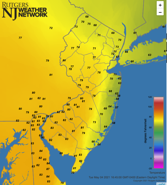
Figure 5. Air temperatures at 4:45 PM on May 4th as recorded at Rutgers NJ Weather Network stations.
Warmth appeared with a vengeance on the 19th, as the first 90° readings of the season were observed at Hillsborough-Duke (91°) and four sites at 90°. Some 46 other NJWxNet stations out of 64 total topped out at 85°–89°. Fortescue and High Point Monument were coolest at 79°. The 19th brought a morning low of 40° and afternoon high of 87° to Walpack (Sussex). The most often cooler northwest saw the warmest weather in the state on the 21st with Sandyston (Sussex) up to 88° and both Pequest (Warren) and Walpack 87°. Seventeen other locations were 85° or 86°, while Sea Girt was coolest at 66°. The two warmest days of the month followed on the 22nd and 23rd. South Harrison (Gloucester) peaked at 94° on the 22nd, followed by 42 NJWxNet stations at 90°–93° (Figure 6). High Point Monument and Vernon Township made it to 80° for the first time this season. Offshore winds permitted the thermometer to soar at coastal locations on the 23rd, with Atlantic City Marina among the ten stations within NJ that peaked at 93°. Thirty-four others reached 90°–91°, while High Point Monument was coolest at 79° (Figure 7). Four stations made it to 92° on the 26th, with 25 either 90° or 91°, making this a rather impressive fourth day of 90° weather this May for many NJ locations (Figure 8). May warmth ended on the 27th with Woodbine and Hamilton (Mercer) climbing to 85°.
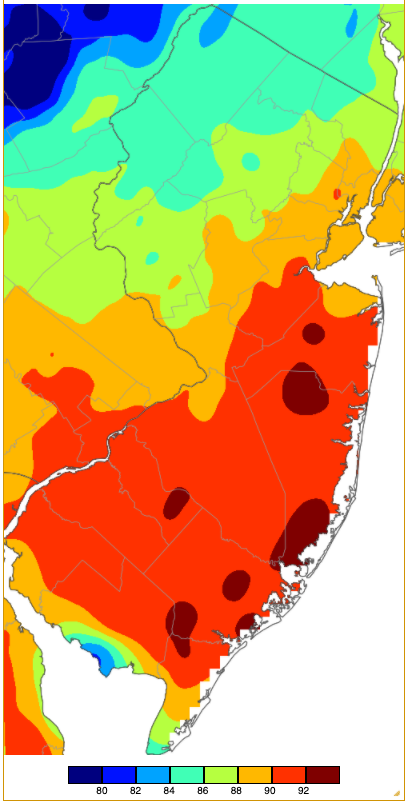
Figure 6. Maximum temperatures on May 22nd based on a PRISM (Oregon State University) analysis generated using NWS, NJWxNet, and other professional weather stations. Note the consistent coverage of temperatures that are aligned with elevation, except for some far-south sea breeze effects (also some on the barrier islands that are not shown).
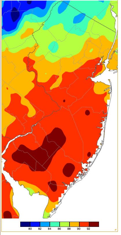
Figure 7. Maximum temperatures on May 23rd based on a PRISM (Oregon State University) analysis generated using NWS, NJWxNet, and other professional weather stations. Note the coverage of temperatures similar to the 22nd only with the mid 80°s a bit farther north.
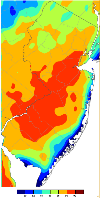
Figure 8. Maximum temperatures on May 26th based on a PRISM (Oregon State University) analysis generated using NWS, NJWxNet, and other professional weather stations. Note a pronounced sea breeze cooling along the entire Atlantic and Delaware Bay coasts.
Daily minimums of 35° or lower were confined to the first half of the month. The 1st found High Point Monument down to 32° with twelve NJWxNet stations from 34°–39°. Cold returned on the 7th, with Walpack at 31°, Pequest 33°, and 20 locations from 34°–39°. Sandyston fell to 30° on the 9th, with Walpack and Pequest at 31°, and 22 sites 35°–39°. Sandyston was 33° and Pequest 34° on the 11th. The 12th found Walpack at 30° and both Pequest and Berkeley Township 33°.
The 13th was the coldest morning of May, with Walpack down to 28°, Sandyston 29°, Pequest 30°, and 24 NJWxNet stations from 33°–39° (Figure 9). Walpack reached 34° on the 15th. The last NJWxNet location with a May freezing temperature, and likely until late summer or early fall, was Berkeley Township at 32° on the 16th. Oswego Lake (Burlington) fell to 34°, while eleven other locations were from 35°–39°. This demonstrates how cold low-lying Pine Barrens locations can become on calm, clear nights, especially when the atmospheric and surface conditions are both dry.
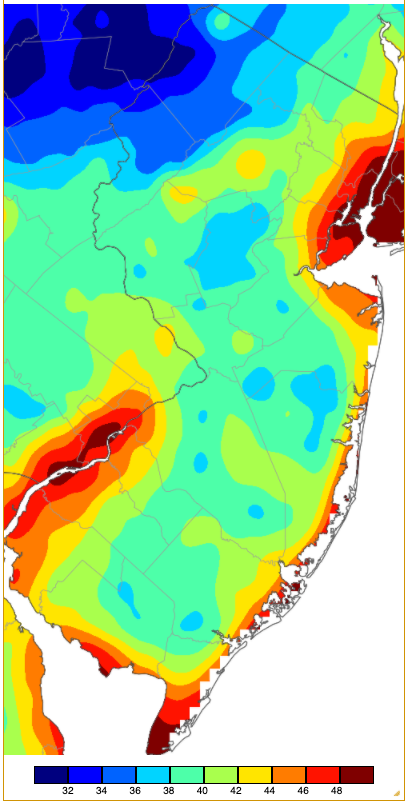
Figure 9. Minimum temperatures on May 13th based on a PRISM (Oregon State University) analysis generated using NWS, NJWxNet, and other professional weather stations. Note the northwest valley cold, cool conditions at lower inland elevations of central and south NJ, somewhat milder minimums in the Highlands, and the least cold in urban and coastal locations.
The unusually cool conditions that occurred late in May were notable in several respects. In particular, the 29th and 30th had daytime temperatures in the 40°s and 50°s, with the highest temperature of 54° found at seven locations on the 30th. Sussex (Sussex) achieved record low maximums of 47° on the 29th and 30th, Newark Airport (Essex) had the same at 52° on the 29th and 53° on the 30th, as did Atlantic City Airport/Pomona (Atlantic) at 54° on both days, and Atlantic City Marina at 54° on the 30th. These highs are 16° to 27° below normal. Even more impressive was High Point Monument only reaching 42° on the 29th with a low of 38°, and 43°/39° on the 30th.
Spring Overview
Rainfall and melted snow averaged 10.70” across NJ during the March–May interval. This is 1.43” below normal and ranks as the 55th driest. The first two months had subnormal precipitation (-0.36” in March and -1.26” in April), with only May coming in slightly above normal (+0.20"). Precipitation was heaviest along the central coast and lowest from northern Burlington through Middlesex counties (Figure 10). The largest spring totals at CoCoRaHS stations included 16.06” and 15.27” at two Brick locations, two Pine Beach stations with 15.25” and 14.11”, Point Pleasant Beach 15.19”, Lacey Township 14.81”, and Berkeley Township 14.45”. On the low end was Lawrence Township (Mercer) with 8.79”, Maurice River Township (Cumberland) 8.83”, New Brunswick 9.35”, Ewing Township (Mercer) 9.36”, and Franklin Township (Somerset) with seven stations reporting 9.55”, 9.55”, 9.59”, 9.68”, 9.84”, 9.84”, and 9.96”.
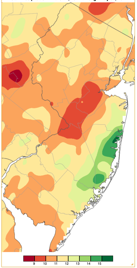
Figure 10. Spring 2021 precipitation across New Jersey based on a PRISM (Oregon State University) analysis generated using NWS Cooperative and CoCoRaHS observations. NJ totals range from 9.00”–9.99” (red) to 15.00”–15.99” (dark green).
The statewide snowfall total for the season was a trace. This was the sixth spring without measurable snow since 1895, other years being 1903, 1913, 1946, 1966, and last year. Only a few locations picked up several tenths of an inch in March and April, but not enough to bring even a divisional total to a measurable level.
The statewide spring temperature averaged 52.5°, which is 1.3° above normal and ranks as the 12th warmest on record. March was +3.0° on the mild side, April +1.1°, and May slightly below normal at -0.2°, all compared to the new 1991–2020 normals. Looking at 1895–2021 period of record mean temperatures, March was 4.5° above normal, April +2.9°, and May +0.9°.


