
 was held on the sunny and dry afternoon of May 26th. The competition is the oldest bicycle race in North America, with top national, international, Olympic, and professional cyclists participating.")

.")
 on March 20th. Photo by Judy Kopitar.")
. Photo by <a href=\"https://www.facebook.com/jan.humphreys.79/posts/pfbid0JLoZ9bemcB7zZ1tFVwbDN9ettxzYBEZfD67ZGQ34EN8GN2jSWfC2GX39RiGHqHt2l\" target=\"_blank\">Jan Humphreys</a>.")
Bitter Cold, a Blizzard, and a Thaw: January 2018 Summary
 to freeze, as seen on the 11th. Photo by Jim Battista.")
The first month of 2018 was replete with cold, warmth, snow, rain, and stretches of dry weather. First came an impressive episode of subfreezing conditions that began in late December and extended into the second week of January. This interval included a storm that brought over 10” of snow and blizzard conditions to coastal counties. Next was a heavy rain event accompanied by much warmer air, then later in the month, several scattered rain and snow episodes interspersed with dry conditions and some 60° warmth. Something for most everyone, I suppose you could say!
The statewide January mean temperature was 29.2°. This is 1.5° below the 1981–2010 mean and ranks as the 55th coldest January of the 124 since 1895. It was the coldest January since 2015. Precipitation (rain and melted snow) across NJ averaged 2.69”, which is 0.71” below average for the month. This was the 39th driest on record and the lowest total since 2010. January snowfall across the state averaged 8.3”, which was 1.1” above average. Northern counties averaged 7.9” (-1.4”), central ones 6.9” (-1.0”), and the south on top with 9.2” (+3.4”). Through January, this snow season has brought an average of 17.0” (+4.1”) to New Jersey, with the north at 16.6” (-0.8”), central 14.7” (+0.3”), and south 17.0” (+4.1”).
 on December 31. Photo by Erik Namendorf.")
 overnight during November 7th-8th, as seen looking northwest towards the Delaware valley fog near Port Jervis, NY. Photo courtesy of Shawn Viggiano.")
 on September 19 (photo by Tim Hawk/NJ.com).")

 early on July 22nd. Photo by Nick Stefano.")
 sky after storms on the evening of June 19. Photo by Twitter user <a target=\"_blank\" href=\"https://twitter.com/davidmkirby/status/876968798267592704\">@davidmkirby</a>.")
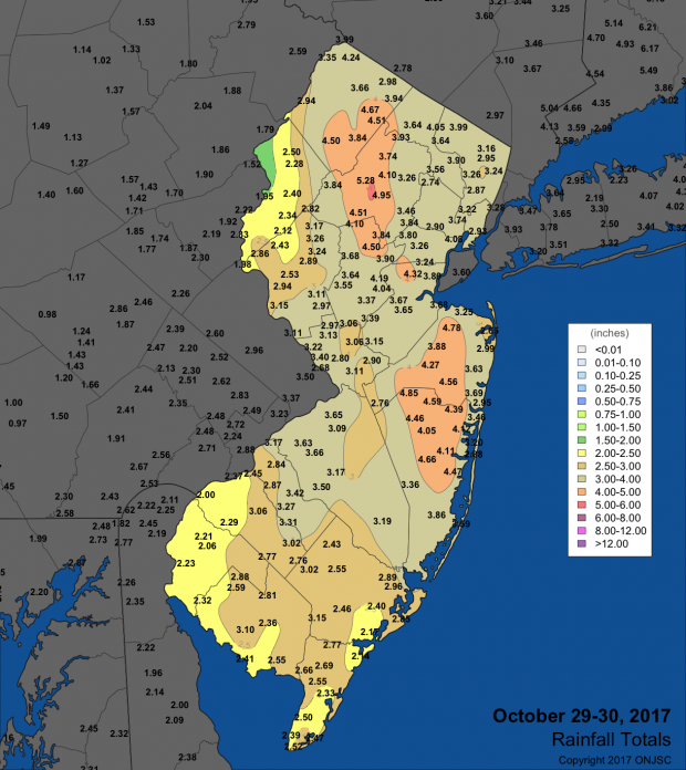
, where around 3.00\" of rain occurred within a three hour period (photo by Bridget Schumacher).")
")