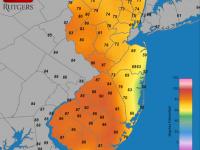
If there is one thing that was consistent with New Jersey's weather in May, and for that matter throughout this past spring (March-May), it was the inconsistency. Of course this is rather typical of many a spring month, as our region sits in the battle zone between reluctantly retreating winter conditions and sporadically advancing summer weather. When all was said and done, May 2013 came in with a near average statewide temperature of 60.7°. This was 0.1° below the 1981-2010 average and ranks as the 53rd mildest May of the past 119 years (1895-present). Precipitation averaged 4.01", a minute 0.01" above average and was the 42nd wettest on record. It was not only day-to-day conditions that varied in May, there were also notable differences in temperature and precipitation from one location to another.
While it took until the last three days of May for warm conditions to persist for more than a day or two, seven days saw the thermometer top out at 85° or higher at one or more of the 55 NJ Weather and Climate Network stations distributed across NJ. The 10th saw Sicklerville (Camden County) and Oswego Lake (Burlington) reach 85°. Walpack (Sussex) hit this mark on the 16th, an interesting situation where the northwest corner of the state was mildest, given its distance from onshore flow of cool ocean-conditioned air that enveloped much of NJ. The 21st saw Hawthorne (Passaic), Haworth (Bergen), and Walpack reach 89°, and five stations rose to 87° on the 22nd.
The state's first heat wave of the year (defined as three or more consecutive days with highs of 90° or better somewhere in NJ) arrived on the 29th. Toms River (Ocean) and Berkeley Township (Ocean) made it to 91°, with four stations coming in at 90°. The heat expanded and intensified on the 30th, with Haworth, Oswego Lake, Toms River, and Hillsborough (Somerset) at 94° and 30 other stations between 90°-93°. Atlantic City Marina was the coolest location at 74°. The 31st was a bit warmer, with Hawthorne and Berkeley Township up to 95°, 34 other stations between 90°-94°, and Atlantic City Marina again the coolest at 76°.
Despite ever-shorter nights, the thermometer managed to drop below freezing somewhere in NJ on nine mornings in May. As expected, these locations were most often the valley stations of Walpack and Pequest (Warren) in northwest NJ or the low lying, sandy Pinelands station in Berkeley Township where daytime heat is rather efficiently radiated to space on clear, calm nights. The 1st saw Pequest drop to 28° and Walpack to 29°. Pequest was 29° on the 2nd, with Walpack and Berkeley Township at 31°. Pequest was 30° and Walpack 32° on the 4th, with both these locations at 30° on the 5th and 31° on the 6th.
The low on the 13th fell to 29° at Walpack and 31° at Berkeley Township. The coldest morning of the month statewide was on the 14th, a rather unusually late date to see multiple locations drop to the freezing mark. Walpack bottomed out at 27° and Hope (Sussex) at 29°, with 10 others between 30°-32°. The mildest locations on the 14th were West Cape May (Cape May) and Harvey Cedars (Ocean), both at 44°. Walpack made it to 31° on the 15th, and joined with Pequest at 30° on the 27th for what may be the last freeze until fall.
Assuming June stays above freezing statewide, a look at the duration of the recent freeze season is in order. The first freezing day last fall was October 8th, when Basking Ridge (Somerset) fell to 32°. A more widespread northern NJ freeze occurred on October 12, when Walpack and Pequest fell to 26° and 29°, respectively. The last freeze of the season was at these two stations on the 27th of May, giving them a freeze season duration of 228 days (Basking Ridge's last freeze was on the 14th, giving that location a 219 day freeze season). On the opposite end of the freezing spectrum, Atlantic City Marina did not fall to freezing until November 29th and last froze on April 4, making for a 127-day freeze season. West Cape May bested this for the shortest duration, with the first freeze on November 28th and last freeze on March 24, making for a 117-day season. This exceptional 111-day difference between longest and shortest station duration is due to the late arrival of freezing conditions near the shore last fall and the rather unusual late freeze in the inland valleys.
Statewide precipitation was discussed above, although the average value hardly tells the entire story of the month. There were two events that deposited over 3.00" at multiple locations, yet other spots did not come close to that amount for the entire month. This resulted in some wet locations, with Franklin Township (Hunterdon) topping the list of close to 200 CoCoRaHS stations at 8.21". This was followed by River Vale (Bergen) with 7.77", two Oakland (Bergen) locations at 7.43" and 7.69", Hawthorne (Passaic) with 7.39", and Harrison (Hudson) and Lebanon (Hunterdon) at 7.30". On the dry side was Pennsville Township (Salem) with 1.70", Wildwood Crest (Cape May) 1.71", Medford Lakes (Burlington) 2.26", Lacey Township (Ocean) 2.32", and Moorestown (Burlington) 2.36".
The first week of May was dry throughout NJ. Next came the first of the two 3.00" episodes. Showers from the second half of the 7th through the morning of the 9th, some accompanied by thunder, pea-size hail (Frenchtown in Hunterdon County), and localized minor road and stream flooding (Helmetta (Middlesex) and Tenafly (Bergen)) deposited as much as 3.88" of rain in Lawrence Township (Mercer). Other hefty totals included 3.54" in Wood Ridge (Bergen), 3.25" in Franklin Township (Hunterdon), and 3.22" in Kearny (Hudson). Ten stations saw in excess of 3.00" and 47 stations between 2.00" and 2.99" of the over 200 CoCoRaHS stations reporting. The rain was heaviest in northeast and west-central areas, while the southeast had under 0.50" at 12 stations, including only 0.15" in Egg Harbor Township (Atlantic).
Rain returned on the evening of the 10th, was scattered throughout the 11th, and ended early on the 12th. This time the most rain fell in the southeast, with Egg Harbor Township topping the list at 2.69". Woodbine (Cape May) caught 2.08" and Linwood (Atlantic) 1.83". The far northwest saw only 0.21" and 0.23" at two Wantage (Sussex) locations. Thunderstorms were observed in some locations with pea-size hail in Medford (Burlington) and strong winds that toppled trees in four counties (see May wind report below).
Moderate rain fell over the eastern half of the state from the afternoon of the 18th through the 19th, ending as drizzle on the morning of the 20th. This persistent event deposited 0.94" in Stafford Township (Ocean), 0.85" at Little Egg Harbor (Ocean), and 0.82" in Estell Manor (Atlantic). Montague (Sussex) only saw 0.04", while Sparta (Sussex), Andover (Sussex), and Elk Township (Gloucester) received 0.05". Lanoka Harbor (Ocean) reported pea-size hail on the 17th.
Heavy rain returned to portions of the northern half of NJ, falling at times during the second half of the 23rd, though the 24th, and into the predawn hours of the 25th. Heaviest accumulations were in a zone extending from northern Hunterdon and Warren counties northeast into Passaic and Bergen counties. This included the bulk of the watersheds that flow into the state's reservoirs, thus fortunately they ended May essentially full. Ringwood (Passaic) saw the largest total of 3.98", followed by North Haledon (Passaic) 3.67", River Vale (Bergen) 3.60", Wayne (Passaic) 3.56", and Oakland (Bergen) 3.55". Fifteen CoCoRaHS stations reported over 3.00" and 42 between 2.00"-2.99". During the late evening of the 23rd into the 24th Pascack Brook in Westwood (Bergen) and the Wanaque River in Wanaque (Passaic) crested within a half foot above flood stage, while the Ramapo River in Mahwah (Bergen) and the Saddle River in Lodi (Bergen) crested within a half foot below flood stage. Less rain fell in the southern half of NJ, with 44 stations receiving less than 0.50" and Wildwood Crest (Cape May) only catching 0.11", Pine Beach (Ocean) 0.18", and Wall Township (Monmouth) 0.21".
The last event of May began during mid morning on the 28th and lasted less than 24 hours. Statewide totals mostly ranged between 0.10" and 0.50", although scattered locations such as Sea Isle City (Cape May) 0.84", Kearny (Hudson) 0.72", Blairstown (Warren) 0.71", and Mine Hill (Morris) 0.68" received a bit more. This was followed by widespread dense fog on the morning of the 29th.
The maximum barometric pressure in May was on the 1st and 2nd, with readings between 30.45" and 30.50". The minimum pressure was close to 29.65" on both the 12th and 24th. Winds gusted to 40 mph or greater on only three days. A thunderstorm on the 11th brought a 46 mph gust to Woodbine (Cape May). A 42 mph gust also accompanied a storm at Jersey City (Hudson). Certainly there were higher localized gusts on the 11th, as trees were reported down in portions of Somerset, Morris, Essex, and Hudson counties. The overall windiest day of May was the 25th with the coastal stations of Seaside Heights (Ocean), Sea Girt (Monmouth), Harvey Cedars (Ocean), and Point Pleasant (Ocean) gusting to 45 mph, 45 mph, 44 mph, and 40 mph, respectively. Inland, Cream Ridge (Monmouth) gusted to 42 mph and 20 other stations peaked between 30 mph – 39 mph. Some branches came down, but there were no reports of significant damage.
Spring Overview
Climatological spring (March-May) averaged 50.3° across New Jersey. This is 0.7° below average and marks the 57th mildest spring of the past 119. The last below average spring was in 2005 (48.9°). The first 90° readings of the year were observed at locations in Camden and Burlington counties on April 10th during a short-lived warm spell. The last freezing conditions were experienced in northwest NJ valleys on May 27th.
Statewide precipitation averaged 9.77" over the three spring months. This is 2.52" below average and made this the 35th driest spring on record. Despite a deficiency in precipitation it fell frequently enough to minimize the fire danger during this vulnerable season. Northern areas were wettest, with Oakland (Bergen) receiving 13.21", followed by Hawthorne (Passaic) 12.90", Randolph Township (Morris) 12.71", Ringwood (Passaic) 12.60", and Lebanon (Hunterdon) 12.59". The southwest and far northwest corners were driest, with Pennsville (Salem) only catching 6.87", Woolwich Township (Gloucester) 7.13", Wantage (Sussex) 7.74", Woodstown (Salem) 7.88", and Collingswood (Camden) 8.12".
Snow only fell in March, with West Milford (Passaic) coming in with 18.4", Hardyston (Sussex) 16.3", Oakland (Bergen) 12.4" and 15.9", and Jefferson Township (Morris) 15.0". At best, several inches fell in the southern third of NJ.


