Overview
The new decade got off on a rather unwintry note, with January temperatures well above average, snow rarely falling, and just one significant storm that brought only rain. The statewide average temperature of 37.3° was 6.6° above the 1981–2010 mean. This ranks as the 8th mildest January (tied with 1933) since records commenced in 1895 (Table 1). Anomalies and rankings were quite similar across the state. January 2020 was milder than December 2019 by 1.0°. The last time this climatological flip occurred was in December 2005/January 2006. Most notably, January 11th and 12th saw record daily temperatures in the upper 60°s to as high as 70°.
| Rank | Year | Jan. Avg. Temp. |
|---|---|---|
| 1 | 1932 | 41.0° |
| 2 | 1950 | 39.7° |
| 3 | 1998 | 38.8° |
| 4 | 2006 | 38.7° |
| 5 | 1913 | 38.2° |
| 6 | 1990 | 38.0° |
| 6 | 1937 | 38.0° |
| 8 | 2020 | 37.3° |
| 8 | 1933 | 37.3° |
| 10 | 2002 | 36.9° |
Table 1. The ten warmest Januaries across NJ since 1895.
Precipitation fell mostly in the form of rain and mainly on the 25th. The monthly average across NJ was 2.38”. This is 1.02” below the mean and ranks as the 26th driest. The north was 1.27” below average, the south -0.84”, and the coast -1.12”, with all divisional totals between 2.14”–2.55”.
The monthly average snowfall for NJ was 1.3”. This is 5.9” below the mean and ranks as the 11th least-snowy January back to 1895. There was only one snowfall event that deposited 2.0” or more at a location somewhere within the state, a rare low value. As a result, the north averaged 2.9”, 6.4” below the mean and the 22nd least-snowy January. Central NJ came in with 2.0”, 5.8” below the mean and earning a 23rd lowest snow ranking. The south barely saw a flake, with 0.1” the average. This is 5.7” below the mean and only the 9th time in the past 126 years with January snowfall coming in at 0.0” or 0.1”. Seasonal snowfall to date is 4.5”, some 8.5” below the mean. This marks the 19th slowest start to the snow season and is the slowest since the 2.3” from October 2006 to January 2007. The 4.5” to date surpasses the full season low totals of 4.0” in winter 1972/1973 and 4.3” in 1918/1919, so there will not be a record low this season.
There were a few things that conspired to keep January rather snow-free. The storm track mainly steered clear of the Mid-Atlantic, thus the overall low precipitation totals. Cold air remained well to our north. This means that most of the precipitation that arrived was in the form of rain. Storms that approached the area mainly tracked to the west, keeping NJ in a mild southerly flow. Finally, the tropospheric (lower atmosphere) polar vortex has stayed well to the north this season. This has not been the case of the western United States being cold and the east warm. All of the lower 48 has been milder than average, while Alaska has been quite a bit colder than average. You must head to the 49th state to find frigid conditions.
Temperature
In this mild January, the thermometer failed to fall to the freezing point anywhere in the state on January 3rd and 11th. Not even the “regular” cold locations in the northwest, be they at the highest locations or in the deeper valleys, saw a freeze on those days. On the other hand, 12 days saw the daily maximum fail to exceed freezing at one or more NJWxNet station. The cold conditions that prevailed at times were neither cold nor sustained enough to generate safe ice conditions on New Jersey’s ponds and lakes. Tragically, this resulted in three separate drownings when individuals fell through thin ice.
Looking first at the higher temperatures achieved in January, there were seven days where multiple locations reached 55°. The first occurrence was on the 4th, with Cape May Court House (Cape May County) reaching 58°, Woodbine (Cape May) 57°, and 16 stations from 55°–56°. An impressive warm spell began on the 10th, with Toms River (Ocean) up to 63°, Berkeley Township (Ocean) 62° (following a morning low of 20°), and nine locations from 60°–61°. Record-breaking temperatures occurred at a number of locations on the 11th and 12th. The 11th found Jersey City (Hudson), Newark Airport (Union), Caldwell Airport (Essex), and Teterboro Airport (Bergen) up to 70°. Eleven NJWxNet stations reached 69°, and 35 rose to between 65°–68°. The coolest location was a still rather mild 55° at Atlantic City Marina (Atlantic). The 12th found the Atlantic City Airport in Pomona (Atlantic) up to 70°, with 69° maximums at Egg Harbor Township (Atlantic) and Mansfield (Burlington). Twenty-two stations were at 68°, and 34 from 64°–67°. Among the 61 NJWxNet stations, this left only three stations cooler than 64°: Fortescue (Cumberland) at 55°, High Point Monument (Sussex) 60°, and High Point (Sussex) 61°.
The 55° mark was reached on the 16th at Cape May Court House, Dennis Township (Cape May), and Woodbine. On the 24th, West Deptford (Gloucester) rose to 59°, Cherry Hill (Camden) 58°, Red Lion (Burlington) 57°, and 19 other stations from 55°–56°. Five stations reached 57° on the 25th, with 14 from 55°–56°.
On the cold side of the ledger, ten days found low temperatures down to 15° or lower at one or more NJWxNet station. Every one of those days included either High Point Monument (HPM), generally associated with cold air being transported into the region from the north, or Walpack (Sussex), most always a function of cold air drainage into valleys on calm, clear nights. The 9th found HPM down to 11°, with High Point and Walpack both 13°, Pequest (Warren) 14°, and Sandyston (Sussex) 15°.
A seven-day period of cold weather, the longest of the month, commenced on the 17th with HPM at 8° and High Point 10°. HPM fell to 7°, High Point 9°, and 10 stations from 12°–15° on the 18th, followed by HPM at 15° on the 19th. HPM dropped to 9° and both High Point and Walpack reached 11° on the 20th. The 21st was the coldest morning of the month, with Walpack 2°, Pequest 5°, Sandyston 7°, Hopewell Township (Mercer) 8°, HPM 9°, and 23 stations from 10°–15°. Lower Alloways Creek Township was “mildest” at 22°. The 22nd rivaled the 21st as coldest, with Walpack down to 3°, Sandyston 5°, Pequest 7°, Hopewell Township 9°, and 20 stations from 10°–15°. Harvey Cedars (Ocean) only made it down to 26°. The 23rd saw Walpack at 7°, Sandyston 8°, and 12 locations from 10°–15°.
Cold returned on the 30th, with Walpack and Sandyston both 11° and seven stations from 12°–15°. The 31st found Walpack at 12° and Sandyston 14°.
Precipitation and Storms
January precipitation totals at individual stations were confined within a rather narrow1.58” range across NJ. On the high end were southwestern stations led by Pitman (Gloucester) at 3.27”, Medford (Burlington) 3.13”, Woodstown (Salem) 3.08”, Pennsville (Salem) 3.05” and 3.00” (two sites), and Winslow Township (Camden) 3.00”. Jersey City was the month’s driest location at 1.69”, followed by Kearny (Hudson) 1.73”, Franklin Township (Somerset) 1.76” and 1.82”, Westfield (Union) 1.82”, Manville (Somerset) 1.85”, and Bridgewater (Somerset), Stafford Township (Ocean), and North Brunswick (Middlesex) each receiving 1.86”.
Monthly station snowfall totals were at a maximum in the northwest hills. Both White Township (Warren) and Jefferson Township (Morris) received 4.1”. Rockaway Township (Morris) and Mine Hill (Morris) each picked up 4.0”, Hackettstown (Warren) and another Jefferson Township station saw 3.9”, and Sparta (Sussex) 3.8”.
The first precipitation event of the month involved a protracted period of on and off mostly light rain throughout the 3rd–4th. Most of NJ received within a few tenths of 0.40”, while higher totals were posted in the far south (Figure 1). Among the highest totals in Cape May County were 0.81” in Sea Isle City, 0.80” at each of three Lower Township locations, and 0.77”–0.78” at three Middle Township stations. Two Flemington (Hunterdon) stations recorded the least, each at 0.22”.
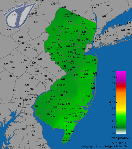
Figure 1. Rainfall from approximately 7AM on January 18th to 7AM on January 19th showing a quite uniform distribution of totals at CoCoRaHS stations.
A fast-moving squall line crossed the state from west to east close to daybreak on the 12th. Totals were greater in the western half of NJ, petering out to the east. Medford quickly picked up 0.69”, Pitman 0.54”, Greenwich (Warren) 0.51”, and Holland Township (Hunterdon) 0.50”. Most of the western half receive several tenths of an inch of rain, with the east coming in under 0.10”.
The 18th saw a mixed bag of precipitation across NJ during the daylight hours into the evening. The far south saw just rain, while 17 of the state’s 21 counties received some measurable snow. In all but the higher elevations, where snow prevailed throughout, the event ended as some sleet, freezing rain, or rain. Rain and melted frozen precipitation amounted to as much as 0.50”, 0.49”, and 0.46” in Woodbine, Sea Isle City 0.47”, and Winslow Township 0.46”. Eight counties had one or more locations receive 2.0” or more of snowfall, with the top total being 3.0” in both Hillsdale (Bergen) and Rockaway Township, followed by 2.9” in Westwood (Bergen), and 2.8” in both Green Pond (Morris) and Hope (Warren).
January 2020 was on a pace to be close to the 5th driest on record until a storm on the 25th doubled and tripled totals that had previously accumulated. Rain began to invade the southwest before dawn and moved northward through the state throughout the morning hours, ending in the northeast during the afternoon. Downpours deposited as much as 2.06” in Pennsville (Salem), Little Falls (Passaic) 1.78”, West Caldwell (Essex) 1.75”, and Princeton (Mercer) and Woodstown each with 1.71”. Of the 209 CoCoRaHS observations, 164 were between 1.00”–2.06” (Figure 2). The lowest total was 0.55” in Lower Township.
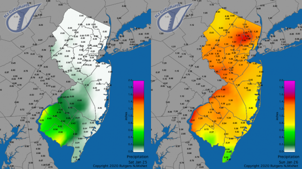
Figure 2. Rainfall from approximately 7AM on January 24th to 7AM on January 25th (left) and from 7AM on January 25th to 7AM on January 26th (right) based on CoCoRaHS station reports.
The barometer topped out between 30.75”–30.80” on the 9th, followed not too far behind by 30.65”–30.75” readings on the 10th, 17th, and 18th. The lowest pressure was recorded on the 4th, ranging from 29.50”–29.55” across the state.
Wind gusts exceeded 40 mph at one or more NJWxNet station on ten January days. Not surprisingly, HPM led the way seven times. The 5th found Fortescue up to 48 mph, Point Pleasant (Ocean) 45 mph, West Cape May (Cape May) 44 mph, and five stations from 41–42 mph. Harvey Cedars reached 50 mph on the 8th, with Pennsauken (Camden) to 49 mph, Pittstown (Hunterdon) and Fortescue each 45 mph, and four stations from 41–44 mph. Berkeley Township reached 40 mph on the 11th and 52 mph on the 12th, when it was joined at that mark by HPM, followed by 49 mph at Atlantic City Marina and Seaside Heights (Ocean), with 11 stations from 41–47 mph.
The 16th saw gusts to 63 mph at HPM, Pennsauken 48 mph, Harvey Cedars 46 mph, and 41–45 mph at 19 stations. Gusts hit 61 mph at HPM on the 17th, along with 48 mph at both Lower Alloways Creek Township and Pennsauken, 46 mph at Harvey Cedars, and 40–45 mph at eight stations. HPM and Lower Alloways Creek Township topped out at 54 mph and 41 mph, respectively, on the 19th, with HPM up to 46 mph on the 20th. Pittstown and Columbus (Burlington) each reached 41 mph on the 25th. HPM gusted to 42 mph on the 28th and 29th.


