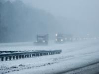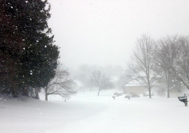
Snow in Hillsborough (Somerset County) on the morning of January 23rd.
Overview
While average monthly temperature and precipitation (rain and melted snow) did not vary much from their long term averages, January 2016 certainly had enough of a potpourri of atmospheric conditions to satisfy (or displease) most anyone in the Garden State. Temperatures ranged from 67° to -2°, a storm deposited as much as 2.35" of rain, and a blizzard dumped record-breaking snow in several locations and caused moderate to major flooding, especially in south Jersey coastal communities.
The statewide monthly average temperature of 31.1° was 0.1° below the 1981–2010 normal and ranked as the 66th coldest since 1895. The temperature averaged 16.7° colder than the record-shattering December 2015 warmth. This is not a record for a December to January swing in temperature, nor for several other monthly pairs too, however it ranks among the largest. Precipitation averaged 3.65", which is 0.17" above normal and 44th wettest. Statewide snowfall averaged 20.0". This was 12.1" above normal and ranks as the 7th highest since 1895 and the largest since the record 23.1" total in 2011. The north received 20.4", which is 11.1" above normal and ranks 13th largest for January, 23.1" (+15.3") fell in central NJ, ranking 5th greatest for the month, and the south averaged 18.2" (+12.5") tied for the 4th highest January total.
Precipitation and storms
Little to no precipitation fell statewide during the first eight days of the New Year. Light rain began on the morning of the 9th and became heavier and steadier late that day and though the morning of the 10th. This was followed by a quick-moving squall line with some embedded lightning/thunder in the north that evening. Event totals were as high as 2.35" in the Morris County communities of Morris Township, Chatham, and Boonton. Of the approximately 200 CoCoRaHS stations reporting, 33 received between 2.00"–2.35", 82 from 1.50"–1.99", and 51 from 1.00"–1.49". Most of northern and central NJ caught at least 1.00", with totals tapering off further south, with the Cape May County communities of Lower Township, Middle Township, and Wildwood Crest seeing 0.40", 0.43", and 0.44", respectively.
Up to an inch of snow in Montague (Sussex) accumulated in an evening squall on the 12th. Five other stations caught as much as 0.5". This was notable, since it was the first observation of an inch or more somewhere in NJ thus far in the winter season. Another measurable event deposited 0.7" in Oakland (Bergen), Rockaway (Morris), and Jefferson Township (Morris) early on the 14th. Little did anyone know that Mother Nature would deposit such totals in minutes a little more than a week ahead.
The next rain event brought 0.50"–1.00" to the southern third of the state and 0.20"–0.50" most everywhere else from late on the 15th through the morning of the 16th. Wildwood Crest topped the list with 1.02" followed by 0.88", 0.93", and 1.00" at three Middle Township stations. Sea Isle City (Cape May) and Estell Manor (Atlantic) each received 0.85". The lowest totals included 0.12" in Cranford (Union) and 0.14" at both Westfield (Union) and Maplewood (Essex).
The first widespread snow event of the season, and the first to dump more than 2.0", occurred during the afternoon into the evening of the 17th. Southern locations picked up the most, including 2.8" at the Atlantic City Airport in Pomona (Atlantic), 2.5" in Pittsgrove (Salem), 2.3" in Little Egg Harbor (Ocean), and 2.2" at Dennisville (Cape May). Totals close to 0.5" were rather common around the state.
The final notable precipitation event of the month was a doozy. Snow began falling in the south during early evening of the 22nd, moving steadily northward. The intensity of the storm grew overnight, with heavy snow falling by the morning of the 23rd, winds howling, and ocean waters pouring into coastal communities at times of high tide after daybreak and later in the evening. Early snow turned over to a mix of snow, sleet, and rain in some central and southern coastal areas, before turning back to snow toward the storm’s end. Elsewhere, snow of varying intensities persisted through the daylight hours and into the evening before tapering off close to midnight.
Tragically, eight NJ residents lost their lives in storm-related incidents. Flood damage was significant along the coast, particularly in the south, where water levels in Cape May County exceeded those observed during Sandy and ranked in the top 10 on record. Beach erosion was moderate to major, particularly from central areas southward. Fortunately, power outages did not become widespread, likely due to the absence of wet snow and freezing rain, along with winds keeping snow from accumulating on tree branches and wires.
A record-breaking snowfall total was observed at Newark Airport (Essex), where the 28.1" storm total eclipsed the previous record of 27.8" in the January 1996 blizzard. Records at the airport go back to 1931. The 26.9" total recorded in New Brunswick (Middlesex) exceeds the 22.6" observed in the 1996 storm. Records in the Hub City date back to 1893. Rather ironically, this storm was the 7th latest occurrence of the first inch or more from an event during all winter snow seasons within the past 124 years.
Storm totals ranged from 6.2" at a station in Wantage (Sussex) to 30.0" at Long Valley (Morris), Succasunna (Morris), and Bernards Township (Somerset). Table 1 lists the maximum and minimum snowfall totals for each NJ county, as deemed representative of local conditions following an exhaustive evaluation of all snowfall totals received from various sources. A complete set of storm totals is available on the ONJSC website here. A map of storm totals (Figure 1) shows the highest values in central portions of the state, particularly between the Interstate 78 and 80 corridors. Snow totals varied by multiple inches over rather short distances for a variety of reasons. They include the abrupt cut off in precipitation in northwestern NJ, the turn over to mixed precipitation along the coast, regional banding of the heaviest precipitation in this dynamic storm, and varying snow measurement practices amongst observers.
|
County |
Minimum Snow |
Maximum Snow |
|
Atlantic |
10.0" |
17.5" |
|
Bergen |
15.1" |
23.9" |
|
Burlington |
10.5" |
22.2" |
|
Camden |
13.0" |
22.0" |
|
Cape May |
7.0" |
11.3" |
|
Cumberland |
10.8" |
13.5" |
|
Essex |
17.0" |
28.1" |
|
Gloucester |
12.0" |
21.0" |
|
Hudson |
25.0" |
26.5" |
|
Hunterdon |
20.7" |
29.6" |
|
Mercer |
16.0" |
24.0" |
|
Middlesex |
16.0" |
28.1" |
|
Monmouth |
16.5" |
25.5" |
|
Morris |
18.0" |
30.0" |
|
Ocean |
12.7" |
23.0" |
|
Passaic |
16.9" |
22.6" |
|
Salem |
12.1" |
14.0" |
|
Somerset |
18.5" |
30.0" |
|
Sussex |
6.2" |
16.0" |
|
Union |
19.0" |
28.3" |
|
Warren |
20.0" |
28.0" |
Table 1. The range of snowfall totals observed in each NJ county during the January 23–24, 2016, blizzard.
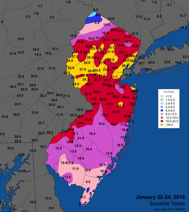
Figure 1. January 23–24th snowfall totals from National Weather Service (NWS) Cooperative observers and spotters, and CoCoRaHS volunteers. For larger view, click here.
Not all regions of the state experienced blizzard conditions during the storm. However, many exposed areas certainly had three or more consecutive hours of winds frequently sustained or gusting to 35 mph or higher and visibility below one quarter of a mile in falling and/or blowing snow to meet the blizzard criteria. Such measures are nearly impossible to meet in sheltered areas such as forests or even wooded suburban locations. Thus I believe it is appropriate to broadly label this storm a blizzard across NJ. And how the wind did howl, with snowfall rates exceeding two inches per hour at times during the storm. Along the coast on the 23rd, Harvey Cedars (Ocean) experienced a gust up to 64 mph and Sea Girt (Monmouth) to 60 mph. Six other NJWxNet stations gusted between 50–57 mph, 14 from 40–49 mph, and 19 from 30–39 mph. Such widespread strong winds had not been observed since Sandy in October 2012, though in most coastal locations gusts were 20 mph lower than in Sandy (except south of Atlantic City where they were nearly equivalent) and up to 30 mph lower inland. It is important to note that while flooding and winds were similar to Sandy along the southern coast, this region was spared the massive destruction that occurred farther north during Sandy.
The only reasonable means of securing a realistically accurate measurement of the liquid equivalent of the snowpack from this storm was to take and melt a core of the snow in an area determined to be representative of the average depth at an observing station. Between the excessive amount of snowfall and the wind, gauge catch of the snow and subsequent melting did not provide a reasonable snow water equivalent (SWE) value for the event. An evaluation of what were deemed to be reasonable SWE measurements found quite close to a 10:1 ratio of snowfall to liquid. This is not always the case for major snows, where ratios tend to be a little larger, however the particular crystalline nature of the snow, ongoing compaction from the deep snow, and perhaps also the wind led to a more dense snowfall than might have been expected. Of course in areas where the snow turned to mixed precipitation or plain rain the ratio was smaller. Thus we estimate that 1.00"–2.00" of melted precipitation fell from this storm in the southern half of the state, less than an inch in the far northwest, and 2.00–3.00" in central and northeastern areas.
The highest barometric pressure during the month occurred on the 5th, with values near 30.65" around the state. The lowest pressure ranged from 29.25"–20.30" on the 10th. Including the winds on the 23rd associated with the blizzard, gusts equaled or exceeded 40 mph somewhere in the state on ten January days. Warm winds on the 10th gusted to 46 mph at High Point Monument (Sussex), 43 mph at Charlotteburg (Passaic), and 40–42 mph at eight other NJWxNet stations. The Monument reached 47 mph on the 11th. The 12th brought gusts of 51 mph at Cream Ridge (Monmouth), 49 mph at High Point Monument, 11 stations between 40–48 mph, and 31 stations from 30–39 mph. Wantage reached 46 mph, the Monument 41 mph, and Harvey Cedars and Sea Girt 40 mph on the 13th.
Wantage and High Point Monument peaked at 48 mph and 45 mph, respectively, on the 18th. The 19th was windy statewide, with the Monument and Wantage up to 55 mph, Sea Girt 44 mph, Mullica (Atlantic) 40 mph, and 35 stations between 30–39 mph. The Monument and Wantage were 49 mph and 43 mph, respectively, on the 20th. The winds of the 23rd were discussed previously, with Wantage holding onto a gust of 46 mph into the 24th. The two windy sites of High Point Monument and Wantage competed a windy month with gusts to 46 mph and 43 mph, respectively, on the 29th.
Temperature
Temperatures throughout January were a roller coaster ride. There was a minimum temperature of 10° or lower and a maximum of 50° or higher somewhere in the state every four (or fewer) days. The only exception was a nine-day interval toward the end of the month where no station reached 50°. Looking first at the warmth, six NJWxNet stations topped out at 52° on the 3rd. Berkeley Township (Ocean) reached the 52° mark on the 7th, followed by Oswego Lake (Burlington) and Toms River (Ocean) at 51°. Both Walpack (Sussex), with a high of 44° and low of 5°, and Berkeley (minimum of 13°), experienced a 39° diurnal temperature range on the 7th.
Greenwich (Cumberland) and West Cape May (Cape May) got to 57° on the 9th. The 10th was the warmest day of January 2016. Oswego Lake and Woodbine (Cape May) led the way at 67°, followed by 10 stations at 66°. Some 38 of the 54 NJWxNet stations topped out between 60°–67°, with the High Point Monument and High Point (Sussex) stations coolest at 54°. West Cape May reached 51° on the 14th, with Cape May Courthouse (Cape May) and Greenwich at 50°. Berkeley Township and Toms River topped out at 58° on the 15th. Sicklerville (Camden) saw 56°, and Cape May Courthouse and Cherry Hill (Camden) 55° on the 16th.
The 26th found Cape May Courthouse and Egg Harbor Township (Atlantic) up to 57° and 55°, respectively. The Courthouse hit 54° on the 27th. The 31st was the second mildest day this month, with Oswego Lake at 65°, Mullica 64°, and 15 stations between 60°–63°. Despite snow cover remaining on the ground in most central and northern locations, every station except Atlantic City Marina (Atlantic) at 49° topped the 50° mark.
Fourteen January days saw the thermometer dip to 10° or lower. First up was the 4th when cold air advection dropped High Point Monument to 0° and High Point to 1°. West Cape May was “mildest" at 18°. The 5th was the coldest day of the month, with the Monument at -2° and High Point 0°. 33 other NJWxNet stations were between 1°–10°, with West Cape May at 15°. The 6th saw cold air drainage into the valleys become more common, with Walpack falling to 1° and Berkeley Township 2°. 24 stations were between 3°–10°. Walpack dropped to 5° on the 7th and Pequest (Warren) 7°. Walpack was by far the coldest location in NJ on the 8th at 9°, with the next coldest spot Hope (Warren) at 18°. Walpack also reached 9° on the 12th before what appeared to be a hungry mouse severed the wire from the temperature sensor to the data logger, putting the sensor out of commission until a replacement was installed on the 31st.
More advective cold appeared on the 14th, dropping High Point Monument to 10°. Additionally, the Monument fell to 9° on the 18th, 7° on the 19th, and 8° on the 22nd. On those days, the High Point station 300 feet lower in elevation got to 10°, 8°, and 9°, respectively, accompanied by Pequest at 9° on the 22nd. The 24th saw Pequest fall to -1° and Hope to 7°. Pequest was 1° on the 25th and Kingwood (Hunterdon) 3°, while along the coast, Atlantic City Marina and Harvey Cedars only cooled to 25°. The 26th found Basking Ridge (Somerset) and Kingwood down to 9°, with Basking Ridge, Hillsborough (Somerset), and Hopewell Township (Mercer) all experiencing 39° diurnal ranges over the still snow-covered ground. On the 27th, Pequest and Kingwood reached 6°.


