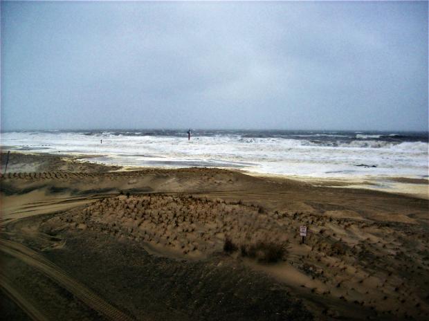
Large waves crashing along the beach in Sea Girt (Monmouth County) on January 23rd. The storm's gale force winds caused considerable beach erosion and some minor to moderate coastal flooding up and down the coast (photo by Jay Amberg).
Overview
A progressive weather pattern dating back to last fall continued to hold serve across the eastern US in January. This resulted in temperatures swinging between mild and cold levels and unsettled weather systems moving through often enough to bring precipitation levels close to average but, with one notable exception, not staying around too long to wreak havoc. Overall, it was a mild month, with a statewide average temperature of 36.2°, which is 5.5° above the 1981–2010 mean. This ranks as the 12th mildest January since 1895. It is interesting to note that while 10 of New Jersey’s warmest 15 years have occurred since 2000 and 14 of 15 since 1990, Januaries have not as often kicked off these warm years as much as one might imagine (Table 1). Only 5 of the 15 mildest Januaries over the 123 year record have occurred since 2000 and just 8 of the 15 mildest since 1990.
| Rank | Year | Jan. Avg. Temp. |
|---|---|---|
| 1 | 1932 | 41.0° |
| 2 | 1950 | 39.7° |
| 3 | 1998 | 38.8° |
| 4 | 2006 | 38.7° |
| 5 | 1913 | 38.2° |
| 6 | 1937 | 38.0° |
| 6 | 1990 | 38.0° |
| 8 | 1933 | 37.3° |
| 9 | 2002 | 36.9° |
| 10 | 1949 | 36.7° |
| 10 | 2007 | 36.7° |
| 12 | 2017 | 36.2° |
| 13 | 1995 | 35.7° |
| 14 | 1947 | 35.6° |
| 14 | 2012 | 35.6° |
Table 1. The 15 warmest Januaries across New Jersey since 1895.
Precipitation (rain and melted snow) averaged 3.69” in January. This is 0.29” above the 1981–2010 mean and ranks as the 43rd wettest on record. Statewide, snowfall averaged 5.8”, which is 1.4” below average. The southern third of NJ received the most snow, coming in with 6.4”, which is 0.6” above average. Central NJ caught 5.8” (-2.1”) and the northern region 4.7” (-4.7”). Season-to-date statewide snowfall is averaging 8.1” (-3.2”), with the highest amount of 32.1” having fallen at the High Point Ranger Station (1500’ elevation in Sussex County).
Precipitation and Storms
There was over a 4” difference between the wettest and driest locations in the state in January. The central and northern coast received ample rain and snow that brought monthly totals as high as 6.80” in Lacey Township (Ocean), 6.32” at Berkeley Township (Ocean), 6.12” to Ocean Township (Monmouth), 5.98” in Belmar (Monmouth), and 5.90” at Manchester Township (Ocean). Southwest NJ was driest, with 2.67” falling in Upper Deerfield (Cumberland), 2.82” in Woodstown (Salem), and 2.92” at Pittsgrove (Salem).
As mentioned, snowfall ran highest in the south, with Berlin (Camden) and Lacey Township each coming in with 9.8” for the month, followed by 9.7” in Wildwood Crest (Cape May), 9.5” in Berkeley Township, 9.4” in Stafford Township (Ocean), and 9.0” at both Mt. Laurel (Burlington) and Little Egg Harbor (Ocean). These are all complete monthly totals; the storm on the 7th deposited 10.7” at Barnegat Light (Ocean) but this is the only January observation available for this location.
The first event of 2017 brought rain to NJ from the predawn hours of the 2nd through the early morning of the 4th. Central and southern coastal areas received the most, with Toms River (Ocean) leading the way with 2.01”, followed by 1.80” in Middle Township (Cape May), and Port Republic (Atlantic) and Ocean City (Cape May) each with 1.50”. Many locations around NJ received 0.75”–1.50”, with Mt. Olive (Morris) at the low end with 0.40”.
Precipitation resumed late on the 5th into the morning of the 6th, this time in the form of light snow. The NJ Turnpike corridor received the most, including 2.5” in Hopewell Township (Mercer), 2.4” in both Burlington (Burlington) and Metuchen (Middlesex), Cherry Hill (Camden) 2.3”, and Franklin Township (Somerset) 2.2”. Little fell to the southeast or northwest of this swath.
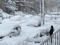
The largest snow event of the month occurred during the daylight hours of the 7th, which marked the 21st anniversary of the blizzard of 1996. Five or more inches fell in 14 counties, with the largest totals listed in Table 2. A coastal storm that deposited heavier snow to the south of NJ sideswiped the Garden State, thus northern counties came out on the short end, especially in Sussex and Warren where less than an inch fell. Leading the way was the aforementioned 10.7” at Barnegat Light, along with an observer in Estell Manor (Atlantic) that measured 9.0”. Perhaps due to bands of snowfall noted during the storm or the windy conditions that made for challenging measurements, another Estell Manor observer reported 7.0”. This was a low-density snow, with Stafford Township having the highest melted equivalent of 0.66”, followed by 0.59” in Long Branch (Monmouth) and 0.57” in Lacey Township (not all volunteers who measured snowfall submitted liquid equivalents).
| County | Location | Snowfall |
|---|---|---|
| Atlantic | Estell Manor | 9.0" |
| Burlington | Marlboro | 6.8” |
| Camden | Haddnon Heights | 6.5” |
| Cape May | Lower Twp. | 8.5” |
| Cumberland | Vineland | 6.5” |
| Essex | Newark Airport | 5.8” |
| Gloucester | Pitman | 7.1” |
| Hudson | Harrison | 5.6” |
| Mercer | Robbinsville | 5.3” |
| Middlesex | Fords | 7.0” |
| Monmouth | Lincroft | 7.9” |
| Ocean | Barnegat Light | 10.7” |
| Salem | Pittsgrove Twp. | 7.0” |
| Somerset | Franklin Twp. | 5.0” |
| Union | Roselle | 5.4” |
Table 2. Greatest snowfall in the 14 NJ counties where totals on January 7th equaled or exceeded 5.0”.
Two fast-moving systems brought relatively uniform rainfall totals of several tenths of an inch (most locations under 0.40”) to the state during the overnight hours of the 10th into the 11th and 11th into the 12th. Some light snow in central and northern sections followed this during the afternoon of the 14th. This brought as much as 2.0” to Lebanon (Hunterdon) and Green Township (Sussex).
It was back to rain on the 17th, although some freezing rain fell in higher elevations up north. Precipitation was on the light side during the day, turning moderate in the evening. This resulted in most NJ locations receiving 0.25”–0.75”, topped by 0.82” in Pine Beach (Ocean) and 0.78” in the Middlesex County communities of North Brunswick and Woodbridge. Ocean City received the least at 0.12”.
The first half of the 22nd saw over 0.25” of rain fall in much of southern and central NJ, with little further north. Egg Harbor Township (Atlantic) topped the charts with 0.46”. This event was a precursor to the most powerful storm of the month, one that is destined to make the 2017 top ten event list. Precipitation moved north into NJ on the morning of the 23rd, was heaviest during the afternoon and evening, and slowly tapered off by the afternoon of the 24th. While mostly rain, sleet mixed in at times in central and northern areas. Notable accumulations of sleet along with some snow fell in the northwest. Lacey Township received the most liquid precipitation, coming in with 3.16”. Other locations exceeding 3.00” included Ocean City and Berkeley Township, each at 3.10”, and Lavallette (Ocean) with 3.05”. Of the 210 CoCoRaHS reports, 29 had storm totals between 2.00”–2.99” and 153 locations were between 1.00”–1.99”. Only the southwest was less than 1.00”, with Upper Deerfield lowest at 0.42” and 0.47” at both Pittsgrove and Woodstown. Sleet and snow amounted to as much as 4.1” and 2.9” at two Highland Lakes (Sussex) locations, 3.5” in Vernon Township (Sussex), and 2.9” at Hardyston (Sussex).
While precipitation was excessive, this storm will best be known for its gale force winds and minor to moderate coastal flooding and beach erosion. Perhaps the windiest storm since Sandy in 2012, 13 NJWxNet stations reported peak gusts of 50–59 mph and 20 maxed out between 40–49 mph. Most notably, Seaside Heights (Ocean) and Sea Girt (Monmouth) gusted to 59 mph, Fortescue (Cumberland) to 58 mph, and 55 mph gusts were observed at Berkeley Township, Mullica (Atlantic), Harvey Cedars (Ocean), and West Creek (Ocean). It is also worth noting that anemometers at two of the often windiest NJWxNet stations (Atlantic City Marina [Atlantic] and High Point Monument [Sussex]) were out of commission during this event. Before the storm departed, the wind gusted to 55 mph at Seaside Heights on the 14th, along with 49 mph gusts at Harvey Cedars and Sea Girt. Tidal levels were 3–4 feet above normal from the morning of the 23rd through peak water level early on the 24th. This resulted in prodigious quantities of sand being swept off shore along the entire stretch of Atlantic beaches and the flooding at high tides of low lying areas of coastal communities.
Calmer conditions prevailed in succeeding days until two minor storms brought snow to the far south on the morning of the 30th and northern and central areas during the daytime hours of the 31st. Each event had liquid equivalent totals of under 0.20”. The first one saw only Cape May County locations coming in with an inch or more. This included 3.8” in North Cape May, 2.5” at Middle Township, and 2.0” in Green Creek. The second gave Montague (Sussex) 3.2”, Oakland (Bergen) 2.0”, Jefferson Township (Morris) 1.9”, Hawthorne (Passaic) 1.7”, Blairstown (Warren) 1.1”, and Harrison 1.0”. Also worth noting were some snow squalls that raced across the southern half of the state in the late afternoon on the 30th. As much as 0.5” fell quickly in some locations, with one squall in Burlington County accompanied by thunder.
The 23rd–24th storm brought the lowest barometric pressures to NJ in January, bottoming out at 29.30”–29.35”. The barometer was as high as 30.70” on the 13th–14th. In addition to the 40 mph or higher gusts on the 23rd–24th, gusts to that magnitude were observed at High Point Monument on the 4th (45 mph), 5th (41 mph), 8th (45 mph), 11th (40 mph), and 13th (46 mph). The Monument anemometer went out of commission during an icing event on the 16th and will be repaired once safe conditions return. The only other 40 mph gusts in January occurred on the 26th with Pennsauken (Camden) reaching 46 mph, Harvey Cedars 45 mph, and 10 other stations 40–44 mph.
Temperature
Temperatures reached 50° or higher at one or more of the 64 NJWxNet locations on 14 January days. On 11 days the temperature fell into the teens or lower. The 1st found Woodbine (Cape May) up to 56°, with five stations at 54°. Six stations reached 51° and seven 50° on the 3rd, with Atlantic City Marina, West Creek, and Woodbine up to 57° on the 4th. Following some cold and snow, temperatures soared to record and near-record levels from the 11th–13th. The first day found Mullica up to 60° and Hammonton (Atlantic), Oswego Lake (Burlington), and Piney Hollow (Gloucester) all at 59°. Warmth enveloped the entire state on the 12th, with Howell (Monmouth), Oceanport (Monmouth), Red Lion (Burlington), and Toms River all reaching 70°. Ten NJWxNet stations topped out at 69°, 21 were between 65°–68°, and 13 from 60°–64°. Southerly winds off of a cool Delaware Bay kept Fortescue with a 51° maximum. Long term National Weather Service stations at Newark Airport and Atlantic City Airport in Pomona (Atlantic) both set record highs at 67°. The 13th saw highs of 64° in Cape May Courthouse (Cape May), 63° at four stations, and 60°–62° at an impressive 37 NJWxNet locations. Walpack (Sussex) was coolest at 49°.
Fifty-degree warmth returned on the 18th and remained for over a week. Woodbine and Bivalve (Cumberland) were 50° on the 18th and Cape May Courthouse 53°, with Jersey City (Hudson), Wayne (Passaic), and Woodbine 52° on the 19th. In the north, Charlotteburg (Passaic) and Walpack reached 56° on the 21st. It was interesting that High Point Monument at 53° was the warmest location in NJ on the 22nd, while seven stations from West Cape May (Cape May) to Stewartsville (Warren) to Haworth (Bergen) got up to 51°. After having the coolest maximum in the state on the very mild 12th, Fortescue was the mildest location on the 23rd at 50°. The 25th found Greenwich (Cumberland) up to 56° and nine stations at 55°. Jersey City, New Brunswick (Middlesex), Mansfield (Burlington), and Woodbine all maxed out at 57° on the 26th, when 26 NJWxNet locations reached 55°–56° and 34 were 50°–54°. High Point Monument was coolest at 44°. Much as the month began, highs exceeded 50° on the 31st, making it up to 51° in Egg Harbor Township and 50° at three locations.
The first sub-20° minimum of 2017 was achieved on the 5th, when High Point Monument fell to 16° and High Point (Sussex, 367’ lower in elevation than the 1755’ Monument station) was 17°. The 6th saw Walpack down to 10°, High Point to 11°, and the Monument at 12°. These three stations were either 10° or 11° on the 7th. The chilling influence of fresh snow cover was abundantly evident on the mornings of the 8th–10th, especially at inland locations where snow was deepest. Fresh snow helps to dry out the overlying atmosphere, thus enhancing cooling, and also insulates the atmosphere from milder underlying soil. Berkeley Township in the Pinelands fell to 4° on the 8th, with Basking Ridge (Somerset) and High Point Monument (despite little snow at the latter) down to 6°. The temperature plunged to -8° at Berkeley Township on the 9th, when Howell, Piney Hollow, and Hopewell Township all hit -2°. Four stations were at -1°, three at 0°, 27 between 1°–5°, and 17 from 6°–10°. Fortescue, Logan Township (Gloucester), and Pennsauken were “mildest” at 14°. Berkeley fell to -6° on the morning of the 10th before rocketing to 45° in the afternoon. Hopewell was -1° and 49 stations bottomed out between 0°–10°.
The 14th saw colder air sweep into higher elevations, with the two High Point stations at 16°. The winds calmed and cold air sank into northwest valley locations on the 15th with Walpack down to 10° and Pequest (Warren) at 12°. The next morning found Walpack at 6° and Pequest 8°. Sub-20° air did not return to NJ until the 30th, when High Point Monument was 16° and Walpack 17°. Both High Point stations were 14° on the 31st, with four stations down to 16°.


