drought

Talk of Drought Evaporates: May and Spring 2017 Recaps

June 5, 2017 - 4:19pm -- Dave Robinson

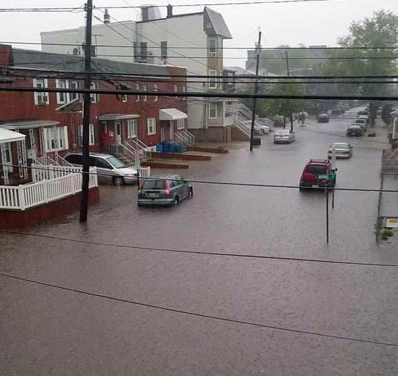
Bayonne street flooding

It is always comforting to enter the water demand season, namely summer, with a bit of a hydrological cushion. Such is the case this year across NJ, thanks to ample rain and some late-season snow in recent months. This timely precipitation has eliminated drought concerns that stemmed from drier-than-normal intervals during 2016. As a result of the precipitation deficits, ground water, streamflow, and reservoirs all dropped to precarious levels, thus the issuance last fall of a drought warning by the NJ Department of Environmental Protection over northern NJ and a drought watch in some southern counties. Aside from two reservoirs in west central NJ remaining below average, at the moment all other hydrological signs are positive. However, no one should let their guard down and fail to appreciate the finite nature of our fresh water resources, and how quickly a period of abundance can lapse again into drought.

More will be noted regarding spring (March–May) conditions later in this report. First taking a look at May, New Jersey experienced its 9th wettest on record, with observations extending back to 1895. The statewide average rainfall of 6.62” was 2.63” above the 1981–2010 average and the wettest May since 1990. Frequent clouds and rain resulted in many chilly days, however, a mid-month heat wave was impactful enough such that the average statewide temperature of 59.8° was only 0.7° below the 1981–2010 average. It was the 61st coolest May of the past 123 years, with none cooler since 2008.

Record Warmth Returns: April 2017 Recap

May 5, 2017 - 2:19pm -- Dave Robinson

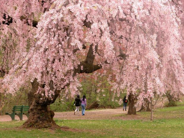
Cherry blossom photo

Following a March with the first substantially below-average monthly temperature anomaly in NJ in over a year, April brought a return to record warmth last seen in February. With a statewide average of 56.0°, the month was 5.1° above the 1981–2010 mean. This ranked as the warmest April since statewide records commenced in 1895. Five of the top 10 and nine of the top 20 mildest Aprils of the past 123 years have occurred since 2002. With the warmth of January, February, and April hardly balanced by the colder March, this year is off to the 4th warmest start on record. Only January–April averages in 2012, 1998, and 2002 were higher, and five of the eight mildest such intervals in the past 123 years have been since 2002. The 12-month period from May 2016 through April 2017 was the third warmest on record at 55.5°. It was only surpassed by May 2011–April 2012 (56.5°) and 2015–2016 (56.2°). Twelve of the 15 warmest such intervals of the past 123 years have occurred since 1999, the others being in 1931–1932 (#10), 1990–1991 (#11), and 1991–1992 (#14).

March in February, & Another Mild Season: February and Winter 2016-2017 Recap

March 6, 2017 - 4:26pm -- Dave Robinson

Crocuses photo

On many an afternoon this past February, one had to be reminded that, according to the calendar, we were in the midst of a winter month. While there was a modest snowstorm for central and northern areas on the 9th, there were 11 days, including the day prior to the storm, when temperatures equaled or exceeded 60° at one or more New Jersey locations. The average statewide monthly temperature of 40.1° made February 2017 NJ’s mildest since records commenced in 1895. The average was 6.6° above the 1981–2010 mean and 1.0° above the previous record in 1998. In fact, the 2017 average was only 0.7° lower than the mean for March, and would rank as the 54th mildest (69th coolest) March on record. February precipitation (rain and melted snowfall) averaged 1.70”. This was 1.10” below the 30-year mean and ranks as the 11th driest on record. Only the storm on the 9th delivered more than an inch of rain or melted snow to some observing stations around the state.

A Rather Quiet End to the Year: December 2016 Recap and Annual Summary, including the Top 10 Events of 2016

January 4, 2017 - 3:40pm -- Dave Robinson

Snow photo

The atmosphere was in a progressive mode throughout December, which explains why no particular weather feature lingered in NJ or elsewhere across North America for too long. The seemingly day-to-day changes resulted in the statewide mean temperature of 36.4° being just 1.2° above the 1981–2010 normal. This ranks as the 28th mildest December since statewide records commenced in 1895, a far cry from last year’s record mild conditions. Despite there being seven precipitation events, one of which was mainly a carry over from November 30th, the rapid movement of these systems meant that none deposited prodigious totals in NJ. Thus 3.37” fell, which is 0.48” below average. This ranks as the 55th driest December. Monthly statewide snowfall averaged 2.0”. This is 2.1” below the 1981–2010 average and ranks 45th least snowy. The northern seven counties averaged 5.5”, the central six counties averaged 1.8”, and the eight southern counties 0.2”, all below average.

Gradual Seasonal Transition: November 2016 and Fall 2016 Recaps

December 8, 2016 - 1:51pm -- Dave Robinson

Snow photo

Much like the entire fall season, the transition into the cold half of the year was in no great hurry in November. Leaves dropped from ten days to two weeks later than normal, but eventually by the 28th the temperature fell to the freezing mark at West Cape May (Cape May County) and Newark Airport (Essex), these being the last locations in the state to experience their first freeze. A major exception to the slowly-transitioning pattern was the moderate high-elevation snowfall the weekend before Thanksgiving.

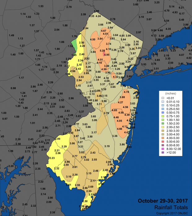
Drought conditions continued to be worrisome across the state, even spreading southwards. However, back-to-back heavy rainfall events on the 29th and 30th provided some replenishment to thirsty soils and began adding water to surface reservoirs across central and northern counties. It will be interesting to see if the atmospheric pattern change that delivered the late-month soakings is fleeting or will be longer lasting. Monthly precipitation (rain and melted snow) averaged 2.48” across NJ. This is 1.13” below the 1981–2010 average and is the 43rd driest November since 1895. It is worth noting that most of the National Weather Service stations that go into determining this average report in the morning. Thus the rain that fell later on the 30th is not factored into the monthly average; rather, it will be part of the December total. Snowfall averaged 0.4” for NJ but broken into regions amounted to 1.3” in the north, 0.1” central, and 0” south. The statewide total is average for Novembers between 1981–2010 but 0.7” below the 1894–present average.

A Climatological Potpourri: October 2016 Recap

November 9, 2016 - 2:21pm -- Dave Robinson

oradell reservoir

Season transitional months are often known for the wide swings in daily and weekly weather conditions. October 2016 did not disappoint when it came to exhibiting such variability. Moisture associated with a weakening hurricane to the south contributed to south Jersey’s heaviest rain event. A modest late-month storm brought the first frozen precipitation of the season to northern counties. Record warmth for so late in the season was part of a dry mid-month week. Halloween eve seeing the temperature touch 80° in some locations before a thunder-strewn frontal passage dropped temperatures to more seasonal temperatures for trick or treating.

Summer is Slow to End: September 2016 Recap

October 5, 2016 - 4:25pm -- Dave Robinson

Sunrise photo

Summer warmth continued into September, only beginning to relinquish its grip on the Garden State during the last week of the month. The average statewide monthly temperature of 70.1° was 4.3° above the 1981–2010 mean. This ranks as the 4th warmest September going back to 1895, with five of the eight warmest Septembers occurring since 2005. Seven of the most recent 13 months have ranked in the top 10 for warmth in their respective months.

Monthly rainfall averaged 3.36” across the state, which is 0.69” below average and ranks as the 61st driest of the past 122 Septembers. However, as discussed below, the average this month does not show the wide disparity of rainfall between the northern and southern parts of the state. While concerns for persistent dry conditions continued increasing across most of NJ through mid September, two soakings in the south alleviated worries in this region. Meanwhile, only one event of note produced totals exceeding an inch in much of the north, thus this region remains much too dry. As of the 27th, a good deal of north and central NJ was considered in moderate drought, with the remainder deemed abnormally dry according to the US Drought Monitor. North Jersey remained under a NJ Department of Environmental Protection “drought watch."

Top Ten August for Heat and Dryness, Yet Another Hot Summer in the 2000s: August and Summer 2016 Recaps

September 6, 2016 - 10:40pm -- Dave Robinson

Beach photo

While above-average temperatures persisted from July into August, the precipitation regime did a 180° reversal between months. A 9th warmest July transitioned to a 2nd warmest August across the Garden State, based on records extending back to 1895. The 14th wettest July proved to be a hydrological blessing following the 20th driest June and preceding the 9th driest August. While August ended with most of New Jersey designated as “abnormally dry” and the northeast in “moderate drought” according to the US Drought Monitor, and north Jersey remained under a NJ Department of Environmental Protection “drought watch,” water supplies would have been in far worse shape come late summer had July been dry.

Near Record Warmth and Quite Dry…until the 30th: September 2015 Recap

October 4, 2015 - 3:30pm -- Dave Robinson

Wildfire photo

The ninth month of 2015 served as a bookend of sorts to an extended warm season. The average statewide temperature of 70.7° was 4.5° above the 1981–2010 normal and ranks as the 3rd warmest on record (since 1895). This ranking is the same as that achieved in May, with the intervening months all above average, though not nearly as much so as these shoulder months. Five of the ten warmest Septembers have occurred since 2002. A look back at the past five months finds that this most recent May through September interval was the third warmest on record. Even more notable than the recent run of warm Septembers, eight of the top ten warm seasons occurred within the last 18 years and four within the last six years.

What had been a rather dry month with drought concerns ended on a damp note on the 30th with a wet episode that extended into early October. Through the 29th, the month ranked as the 14th driest. However, an approximate statewide-average rainfall of 1.50” on the 30th brought the monthly average to 3.44” (-0.63”) and with it the rank of 63rd driest.

New Jersey Smart Lawn Watering Initiative: Conserving Water Starts With You!

September 15, 2015 - 4:49pm -- Jessica Raff

Grass photo

About 70% of the fresh water used around the world is devoted to irrigation, and a similar figure holds true with respect to New Jersey’s water use. Much of this in New Jersey is put towards lawn watering. It is apparent to anyone paying attention to the frequency and timing of when lawns are watered that, just as research suggests, many New Jersey homeowners are over-irrigating their lawns. This wastes precious water that could be conserved wisely by employing more efficient irrigation methods. This article outlines a simple way that you can participate in our New Jersey Smart Lawn Watering Initiative without investing in new sprinkler equipment or devoting large amounts of time to lawn management. By following the instructions discussed below, you can save water and money, while keeping your lawn green and beautiful.

Pages

Subscribe to RSS - drought