Overview
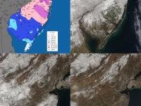
While April 2021 did not have a flare for the dramatic, it did provide a bit of a last look at winter and a glimpse ahead to summer. Overall, it was milder and drier than normal, but not exceedingly so for either variable. The statewide average temperature of 52.6° was 1.1° above the 1991–2020 normal*. Compared to an average over the 1895–present period, the temperature was 2.9° on the plus side, thus explaining the 2021 ranking as the 17th warmest April since 1895. Precipitation averaged 2.47”, which was 1.23” below normal and ranks as the 22nd driest. Coastal areas were wettest with approximately 3.50”–4.50” of rain, a good portion of the state received 2.50”–3.50”, while scattered areas were under 2.50” (Figure 1). Statewide and divisional snowfall came in at a trace.
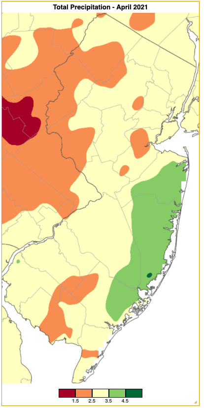
Figure 1. April 2021 precipitation across New Jersey based on a PRISM (Oregon State University) analysis generated using NWS Cooperative and CoCoRaHS observations from 7 AM on February 28th to 7 AM on March 31st. Totals range from 0.50”–1.49” (red) to 4.50”–5.49” (dark green).
*NOAA’s National Centers for Environmental Information (NCEI) has released 1991–2020 averages for NJ monthly temperature and precipitation. In this report, we are using these values for the first time when discussing departures from normal. For the past decade we have used 1981–2010 normals, thus the difference with the new normal compared to what we’ve used previously is the addition of the past decade and the removal of 1981–1990. More will be reported on changes in a forthcoming note from our office, but a quick look shows that, overall, temperature normals have warmed in eleven months and annually (November cooled slightly). Precipitation increased in nine months and annually (April, May, and November became drier).
Temperature
The thermometer swung back and forth weekly during April, with the minimum below freezing at one or more Rutgers NJ Weather Network stations on 16 days from the 1st to the 27th, and maximums reaching 70° or higher on 14 days from the 5th to 30th. Eight days saw locations down to freezing and others up to 70°. In fact, on four days, Walpack (Sussex County) reached both marks, including a high of 75° and low of 30° on the 7th.
Of the warmer maximums, Mansfield (Burlington) started things off with 72° on the 5th. Sicklerville (Camden) followed at 75° on the 6th, with 34 NJWxNet stations (out of 62) from 70°–73°. The evening found air temperatures falling into the upper 40°s to low 60°s (Figure 2) with an unusual distribution of atmospheric moisture across the state. Very dry conditions prevailed in northern and central NJ, with dew points from the single digits to 20°s, but were as high as the low 40°s in the south (Figure 3). Thus, relative humidity ranged from the teens in central NJ to near 60° along the southern coast (Figure 4).
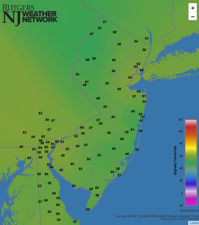
Figure 2. Air temperatures at 8:40 PM on April 6th as recorded at Rutgers NJ Weather Network stations.
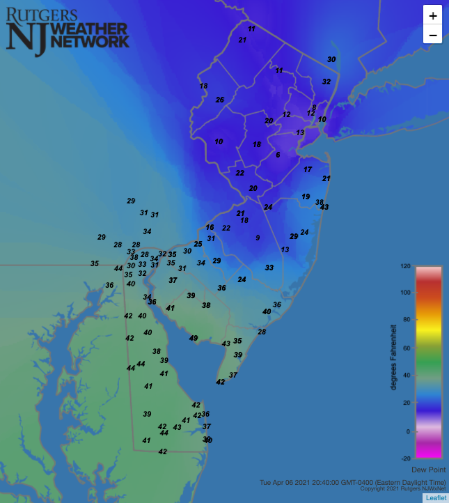
Figure 3. Dew point temperatures at 8:40 PM on April 6th as recorded at Rutgers NJ Weather Network stations.
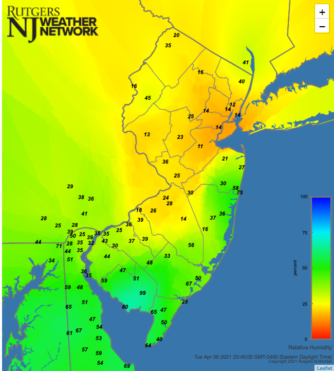
Figure 4. Relative humidity at 8:40 PM on April 6th as recorded at Rutgers NJ Weather Network stations.
Walpack and Sandyston (Sussex) led the way with 75° on the 7th, with Sandyston again on top on the 8th at 74°. The scene shifted to the south on the 10th with Piney Hollow (Gloucester) and Sicklerville each 76°. Mannington (Salem) and Upper Deerfield (Cumberland) followed with 76° on the 11th. Next, it was up to the northern coast, with Holmdel (Monmouth) and Point Pleasant (Ocean) at 72° on the 14th.
A 77° maximum was achieved at Berkeley Township (Ocean), West Deptford (Gloucester), and Sicklerville on the 20th, with 50 stations from 70°–76°. It was much cooler at the coast with Atlantic City Marina (Atlantic) only reaching 60°. The 21st found four stations up to 76°, but this time it was Sea Girt (Monmouth) that only made it to 60°. These readings were reached in the late morning and early afternoon prior to a strong cold front passage that lowered temperatures from west to east by upwards of 20°–25° in not much more than an hour (Figures 5, 6, 7). Storminess associated with the front is discussed in the next section.
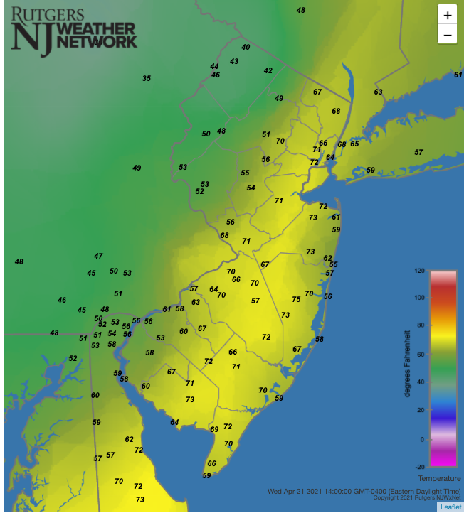
Figure 5. Air temperatures at 2:00 PM on April 21st as recorded at Rutgers NJ Weather Network stations.
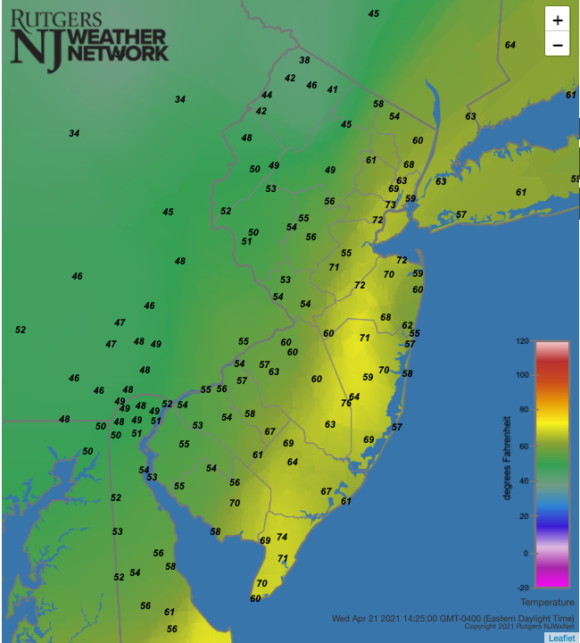
Figure 6. Air temperatures at 2:25 PM on April 21st as recorded at Rutgers NJ Weather Network stations.
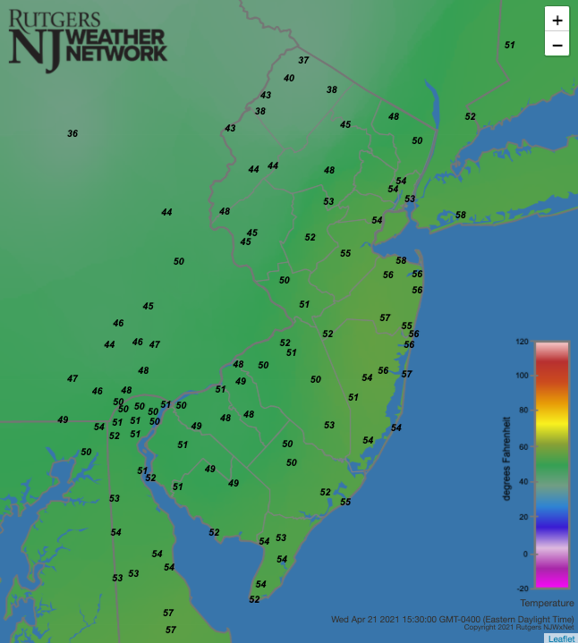
Figure 7. Air temperatures at 3:30 PM on April 21st as recorded at Rutgers NJ Weather Network stations.
The 24th had an impressive dozen stations all taking top honors at 70°. Warm days following cool mornings were found on the 27th and 28th. Greenwich (Cumberland) reached 81° on the first day, with four stations at 80°. Meanwhile, a few stations had a 42° diurnal range, while Sea Girt and Point Pleasant only made it up to 56°, joining three other coastal stations with either 13° or 14° diurnal ranges. The first 90° readings of the season occurred on the 28th, with that mark reached at West Deptford, West Creek (Ocean), and Sicklerville. Highs of 85°–89° occurred at 45 stations, with 80°–84° readings at 13 others. Fortescue (Cumberland) was coolest at 74°, and Walpack had a low of 41° and high of 88°. Atlantic City Airport in Pomona (Atlantic) had a record high of 89°.
The warmth continued on the 29th, with 83° reached at Cape May Court House (Cape May), Piney Hollow, Sicklerville, and Woodbine (Cape May). The previous day’s warmth held over into the early hours of the 30th. Prior to a morning cold front passage, Cape May Court House sat at 77° and Egg Harbor Township (Atlantic) 76°.
The first seven days of April brought subfreezing minimum temperatures to some NJ locations. High Point Monument (HPM; Sussex) reached 26° on the 1st and High Point (Sussex) 27°. The 2nd was the last day of the season with every NJWxNet station dipping to the freezing mark. It was as cold as 17° at HPM and “mild” as 32° at Atlantic City Marina, Harvey Cedars (Ocean), and West Cape May (Cape May). The 3rd found Sandyston and Walpack down to a monthly minimum 15° with only West Cape May (34°) and Lower Alloways Creek Township (LACT; 33°) failing to fall to freezing. Sandyston reached 28° on the 4th, Pequest (Warren) and Walpack 29° on the 5th, Walpack 25° on the 6th, and Berkeley Township 29° on the 7th.
Sandyston fell to 32° on the 14th and 29° on the 16th. Seven of the eight days from the 20th–27th saw subfreezing temperatures at some NJ locations. Walpack dropped to 31° on the 20th and HPM 28° on the 21st. Two cold nights followed with HPM down to 24° and 12 NJWxNet stations from 26°–32° on the 22nd, and Walpack to 26° and 11 stations from 28°–32° on the 23rd. Walpack reached 28° on the 24th, HPM 30° on the 26th, and both Walpack and Berkeley Township 31° on the 27th.
Precipitation and Storms
As in March, coastal NJ saw the most April precipitation, only this time further up the coast. Brick (Ocean) led the way with 4.51” followed by Point Pleasant Beach (Ocean) 4.50”, Toms River (Ocean) 4.40”, Berkeley Township 4.35”, and to the west, Haddon Heights (Camden) 4.17”. The driest conditions prevailed in the northwest, with Blairstown (Warren) receiving just 1.39”, Newton (Sussex) 1.66”, Frelinghuysen Township (Warren) 1.84”, Washington Township (Warren) 1.90”, and Greenwich Township (Warren) 1.92”.
Included in the monthly precipitation totals was rain from an event that began during the afternoon of March 31st and continued to the morning of the 1st. As explained in past reports, this precipitation applies to April totals. Less than 0.25” fell in the northwest, so this did not greatly influence the monthly values listed above, however, parts of the south saw amounts that contributed significantly to monthly totals (Figure 8). Medford Lakes (Burlington) received 1.82”, Southampton Township (Burlington) 1.74”, Pennsville (Salem) 1.61”, Point Pleasant Beach 1.59”, Evesham (Burlington) 1.57”, and Howell (Monmouth) 1.56”. Of the 252 CoCoRaHS reports, 66 exceeded an inch, with 19 under 0.25”. A few tenths of an inch of snow fell at elevations above 1400 feet in the north.
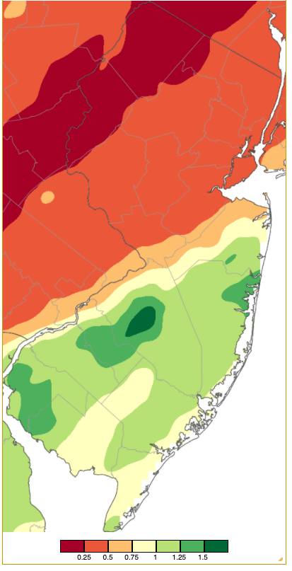
Figure 8. Rainfall from approximately 7 AM on March 31st to 7 AM on April 1st based on a PRISM (Oregon State University) analysis generated using NWS Cooperative and CoCoRaHS observations.
Rain began in the predawn hours of the 11th, moving from southwest to northeast during the morning, continuing in spots until early on the 12th. Localized heavy totals reached 1.59” in Woodbury (Gloucester), Mount Ephraim (Camden) 1.57”, Egg Harbor City (Atlantic) 1.47”, with 77 CoCoRaHS stations over 1.00” (Figure 9). Some thunder was heard in coastal locations during the event.
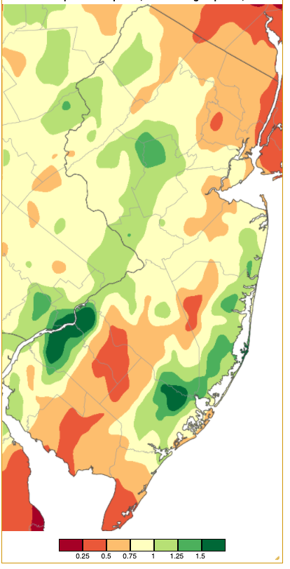
Figure 9. Rainfall from approximately 7 AM on April 10th to 7 AM on April 12th based on a PRISM (Oregon State University) analysis generated using NWS Cooperative and CoCoRaHS observations.
Rain resumed during the morning of the 12th, continuing off and on until early on the 13th, primarily in the north where two Wayne (Passaic) sites caught 0.81” and 0.77, Glen Rock (Bergen) 0.80”, and Little Falls (Passaic) 0.74”. Morning rain along the coast on the 15th moved into northeastern NJ during the afternoon. Tenafly (Bergen) totaled 0.91”, two Long Branch (Monmouth) stations 0.81” and 0.76”, Bergenfield (Bergen) and Ocean Township (Monmouth) each 0.76”, and Bradley Beach (Monmouth) 0.75”.
The aforementioned front on the 21st brought numerous reports of lightning, hail, brief downpours, and gusty winds throughout the state. Pea to dime size hail fell in at least eight counties, rain amounted to as much as 0.51” in Hackettstown (Warren), 0.38” in Holland Township (Hunterdon), and 0.36” in Vernon Township (Sussex). Wind gusts brought down some trees and power lines, registering 63 mph at Atlantic City Airport in Pomona, Mystic Island (Ocean) 62 mph, Fortescue 58 mph, Atlantic City Marina 52 mph, and 12 WxNet stations from 41–47 mph. The cold air behind the front brought unstable air that resulted in snow squalls in central and north Jersey early on the 22nd that dusted the ground in places up to 0.1” in Califon (Hunterdon). Later in the morning, a squall crossed from southwest Jersey almost reaching the coast.
Morning rain on the 25th deposited 1.14” in Sea Isle City (Cape May), Linwood (Atlantic) 1.09”, Wildwood Crest (Cape May) 1.05”, and Ocean City (Cape May) 1.02” (Figure 10). Of 252 CoCoRaHS reports, 167 were from 0.50”–1.00”. Early morning rain on the 29th in the far northwest brought 0.89” and 0.57” to two Vernon Township sites, Branchville (Sussex) 0.71”, and Wantage (Sussex) 0.53”. Afternoon rain on the 29th across northern portions of south Jersey deposited 0.69” in Gloucester City (Camden), Colts Neck (Monmouth) 0.64”, and Southampton 0.63”.
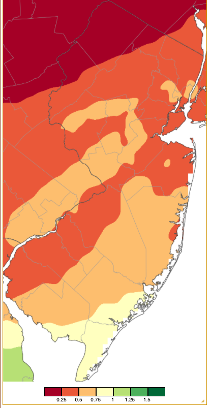
Figure 10. Rainfall from approximately 7 AM on April 24th to 7 AM on April 25th based on a PRISM (Oregon State University) analysis generated using NWS Cooperative and CoCoRaHS observations.
The highest barometric pressures of the month were in the 30.35”–30.45” range on the 3rd. Lowest pressures were from 29.35”–29.50” on the 30th. The transition from low to high pressure early in the month was accompanied by winds gusting on the 1st to 54 mph at HPM, 42 mph at LACT, and 40 mph at both Wantage and Fortescue. HPM reached 44 mph on the 2nd. HPM was up to 43 mph and Seaside Heights (Ocean) 40 mph on the 5th.
Winds slackened until later in the month when eight of the last ten days saw 40 mph gusts at one or more locations. The previously-mentioned gusts on the 21st started things off. This was followed on the 22nd with HPM up to 45 mph, Sea Girt and Atlantic City Marina each to 42 mph, and three stations either 40 mph or 41 mph. HPM was the sole station gusting above 40 mph on the 23rd (42 mph), 25th (43 mph), 26th (46 mph), and 28th (43 mph). Strong gusts began to become more widespread on the 29th with Logan Township (Gloucester) up to 47 mph, Moorestown (Burlington) 43 mph, and Pennsauken (Camden) 40 mph. One of the windiest days in recent years occurred on the 30th as a storm deepened over Atlantic Canada and high pressure began moving into NJ from the west. LACT reached 61 mph, Fortescue 56 mph, Moorestown 55 mph, Harvey Cedars 53 mph, both Columbus (Burlington) and Pennsauken 52 mph, and Seaside Heights and Pittstown (Hunterdon) each 50 mph. An impressive 23 NJWxNet stations had peak gusts from 40–49 mph.


