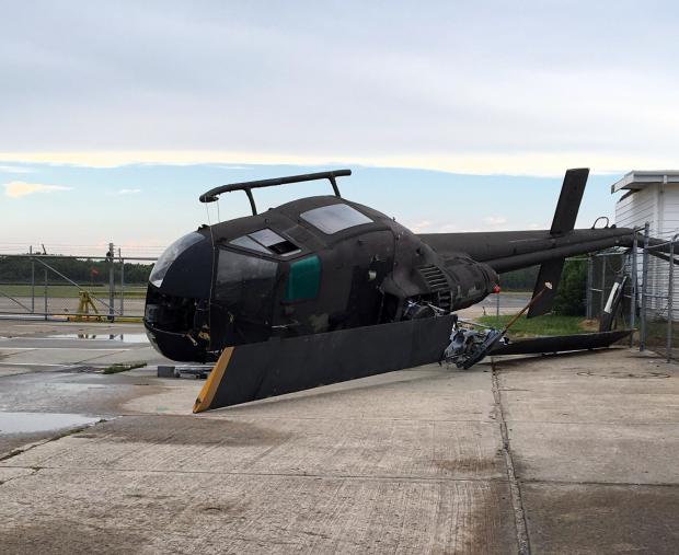
Strong thunderstorm winds toppled a helicopter and flipped a small plane at Cape May County Airport (Lower Township) on the afternoon of June 21st. Photo by Twitter user @Villasone.
Overview
Despite some damaging storms impacting portions of New Jersey on several days and some localized deluges near month’s end, June rainfall came in well below average. The statewide average of 2.36” was 1.66” below the 1981–2010 average. This ranks as the 20th driest June since 1895. Northern and central counties were generally drier than those to the south. At month’s end, the counties from Hunterdon, Somerset, and northern Middlesex northward were classified as being in “moderate drought,” the D1 category on the US Drought Monitor. The counties to the south, through Ocean and Burlington, were in the Monitor’s “abnormally dry” D0 category. June stream flow, ground water, and precipitation levels were all well below average, while reservoir capacities in the north began to dip below average near the end of the month.
Temperatures began on the cool side, but the second half of the month was warm enough to bring the statewide average June temperature to 70.6°, which was 0.5° above average. This ranks as the 30th mildest June on record. There was one minimal heat wave at some inland lower-elevation locations, where temperatures climbed to 90° or higher from the 19th–22nd. However, no location exceeded 93° this month. The dry conditions helped to rid the atmosphere of the previous day’s warmth during the nighttime hours, thus temperatures of 45° or lower were observed in spots on seven mornings.
Precipitation and storms
Monthly totals ranged from 6.35” in Fairfield (Cumberland) to 0.99”, 1.13”, and 1.24” at three locations in Stafford Township (Ocean). Other wet locations included two Washington (Warren) stations with 5.99” and 5.15”, Lebanon (Hunterdon) 5.64”, Glen Gardner (Hunterdon) 5.59”, Dennis Township (Cape May) 5.07”, Upper Deerfield (Cumberland) 4.95”, and three locations in Middle Township (Cape May) at 4.88”, 4.51”, and 4.21”. Other dry locations included Lambertville (Hunterdon) 1.30”, Wantage (Sussex) 1.37”, Medford Township (Burlington) 1.46”, Frenchtown (Hunterdon) 1.48”, and Flemington (Hunterdon) 1.49”. As will be seen below, the huge difference in monthly precipitation across Hunterdon County was mainly due to one heavy event in Lebanon that was missed by the other sites. Lebanon is only nine miles from Flemington, yet their monthly totals differed by 4.15”.
While there were ten days where one or more location in the state received at least 0.50” of rain (eight of these with at least an inch somewhere), there was no event that could be categorized as a statewide soaker. The first rainfall came in the form of scattered thunderstorms during the late afternoon and evening of the 4th. They occurred in northwest and northeast corners, with the heaviest cell dropping 1.74” on Saddle Brook (Bergen County), where roads were briefly flooded. Elsewhere, Madison (Morris) received 0.94”, Little Falls (Passaic) 0.90”, and Andover (Sussex) 0.79”.
An evening squall line crossed NJ on the 5th. This resulted in one of the more widespread rainfalls of the month, with 16 of the 205 reporting CoCoRaHS stations over an inch, and 87 between 0.50”–0.99”. The rain was heaviest in the Interstate 80 corridor in the north and along the north central coast. Manchester Township (Ocean) caught 1.33” and Brick Township (Ocean) 1.25”. Wildwood Crest (Cape May) came in with the least at 0.04”. The wind gusted to 50 mph at Upper Deerfield and 43 mph at Cream Ridge (Burlington) and Logan Township (Gloucester), with 18 of the 56 NJWxNet stations that observe wind gusting between 30–39 mph. Trees were down in scattered areas, falling onto power lines, homes and, automobiles, though not in great abundance.
Isolated afternoon thunderstorms mainly affected southern portions of the Highlands on the 7th. Mount Olive (Morris) and Far Hills (Somerset) each received 0.61”, with Hampton (Hunterdon) at 0.56”. Little fell elsewhere, except a few tenths in the southwest. Again in some locations, tree-toppling winds gusted over 40 mph; for instance 47 mph in Upper Deerfield, 46 mph in Mullica (Atlantic), 44 mph at High Point Monument (Sussex), and 41 mph in Woodbine (Cape May).
Another squall line crossed NJ during the early afternoon of the 8th. The heaviest rain fell from Hunterdon County east to northern Monmouth County, where the towns of Freehold (1.02”), Long Branch (0.94”), and Rumson (0.91”) received the most. Pea to marble size hail was reported in White Township (Warren), Brick Township, and Cinnaminson (Burlington). 96 CoCoRaHS stations caught from 0.50” to 1.02”, with most of the northern two thirds of the state over 0.25”. Less rain fell to the south, however, winds were strongest in this region than further north, bringing trees down on wires and homes. Upper Deerfield was blasted with a 72 mph gust, Harvey Cedars (Ocean) reached 66 mph, Mullica 57 mph, Logan Township 55 mph, and Fortescue (Cumberland) and Red Lion (Burlington) each at 53 mph. 14 other stations gusted into the 40s mph and 12 into the 30s mph.
Dry conditions ensued for the next week, and on Sunday the 12th a brush fire engulfed 300 acres in Stafford Township. No buildings were lost but Route 72 was closed for several hours as weekend beach goers were trying to head home.
Scattered rain fell from the pre dawn hours of the 16th through the same hours on the 17th. Upper Deerfield caught 1.04”, while Middle Township (Cape May) and Woodbine each received 1.03”. The far south saw the most, with a few widely scattered moderate patches to the north where most spots saw less than 0.10”.
Two episodes of storms struck the southern half of NJ on the 21st. The period surrounding dawn brought some rain, while heavier quantities fell in the far south and along the Interstate 195 corridor in the central region from the afternoon into the evening. Jackson (Ocean) received 1.41” and Dennis Township 1.06”. Some northwest locations saw 0.10”–0.20” but other spots had less. Hail from pea to quarter size was observed in Brick Township and Barnegat (Ocean). A severe thunderstorm raked the Delaware Bay coast and Lower Township (Cape May). Winds gusted to 56 mph in Fortescue and 48 mph in West Cape May (Cape May). Approximately 3 miles north of the latter station, a microburst brought gusts that likely were close to 80 mph in and near Villas (Cape May). Falling trees did severe damage to a dozen homes and impacted at least 30 others. A small plane was overturned and a roof came off a building at the Cape May County Airport (Lower Township), and a roof was damaged in Atlantic City (Atlantic). Falling trees brought down power lines, with over 10,000 customers without power for an extended period. Fortunately, there were no severe injuries reported.
Southern areas again saw some rain on the evening of the 23rd. Pennsville (Salem) saw 0.67” and Lower Township 0.58”. Many areas throughout NJ saw no rain, with a few scattered areas picking up 0.10”–0.20”. Several slow-moving downpours developed over portions of Salem, Gloucester, Cumberland, Atlantic, and Cape May counties during the mid day and afternoon of the 24th. Fortescue was doused with 2.84”, Dennis Township 2.29”, Franklin Township (Gloucester) 1.89”, three Middle Township stations at 1.76”, 1.45” and 1.20”, and three Upper Deerfield locations with 1.67”, 1.50”, and 1.38”.
Daytime storms on the 27th brought heavy rain but no severe weather mainly to Cumberland, northern Cape May, and southern Atlantic counties. Fairfield received 2.57”, Dennis Township 1.86”, Egg Harbor Township (Atlantic) 1.72”, and two stations in Woodbine came in with 1.69” and 1.29”. Of the 215 reporting CoCoRaHS stations, 17 received more than an inch, with 50 between 0.50”–0.99”. The far southwest and north central areas had less than 0.20”.
The heaviest local rain of the month soaked an area from northern Hunterdon and southern Warren counties eastward into southern Morris and northern Somerset counties during the afternoon and evening of the 28th. Washington (Warren) was deluged with 3.97”, followed by 3.90” at one Lebanon location and 3.65” in Glen Gardner. 42 of 201 CoCoRaHS reports exceeded an inch, with 41 from 0.50”–0.99”. Little to no rain fell in the southern half of NJ.
The highest barometric pressure in June occurred on the 19th, with readings close to 30.35”. The lowest pressure was on the 6th, with values near 29.45”. Each of the five days that saw winds gust to or above 40 mph were documented in earlier portions of this section, thus will not be repeated here.
Temperature
Eight June days saw the thermometer top out at 90° or higher at one or more of the 60 NJWxNet stations or one of the eight National Weather Service airport stations around NJ. Cherry Hill (Camden), Sicklerville (Camden), and South Harrison (Gloucester) reached 90° on the 1st. It was not until the 11th that the mark was reached again, when a remarkably uniform array of high temperatures across the state saw Hamilton (Mercer), Jersey City (Hudson), Mansfield (Burlington), and Oswego Lake (Burlington) hit 91°. Otherwise, 18 NJWxNet stations reached 90°, 13 got to 89°, and nine to 88°. Five of the eight airport stations topped out at 90° and Newark Airport (Essex) at 91°. Three NJWxNet stations were coolest at 80°.
Woodbine soared to 93° on the 12th and West Creek (Ocean) 92°. Millville Airport (Cumberland) also reached 93°. 17 other stations were 90° or 91°, while it only reached 73° at High Point (Sussex) and High Point Monument.
The warmest spell of June began on the 19th, with Hawthorne (Passaic), Hamilton (Mercer), Red Lion, and both Trenton (Mercer) and Somerville (Somerset) airports up to 93°. 22 stations were between 90°–92°. The 20th was almost a carbon copy of the previous day, with Hamilton, Somerville Airport, and Red Lion again at 93°, joined by Hillsborough (Somerset). 21 stations were between 90°–92°. Five stations reached 90° on the 21st, when Newark Airport was warmest at 91°. Jersey City led the way with 91° on the 22nd, followed by Red Lion, Newark Airport, and Atlantic City Airport (Atlantic) at 90°. Hillsborough saw the lone 90° reading on the 26th.
The first of seven mornings with minimum temperatures of 45° or lower occurred on the 8th, when High Point Monument dropped to 45°. The 9th saw Walpack (Sussex) at 40°, the Monument 42°, four locations at 44°, and one at 45°. The 10th was the coldest morning of the month, with Walpack falling to a chilly 39°. Pequest (Warren) was 41°, Basking Ridge (Somerset) and Hopewell Township (Mercer) 42°, Kingwood (Hunterdon) and Somerville Airport 43°, and Howell (Monmouth) and High Point Monument 44°. Four stations fell to 45° and 14 were between 47°–49°.
Walpack again fell to 39° on the 11th, with Basking Ridge and Pequest at 42°, eight stations 43°–45°, and again 14 stations from 47°–49°. This was a day that warmed up considerably, with some stations topping out over 90°. Walpack rose to 88°, giving this site an impressive 49° diurnal temperature range. Oswego Lake and Basking Ridge each had diurnal ranges of 47°.
Walpack fell to 44° and High Point Monument 45° on the 14th. Walpack was 41°, Pequest 44°, and Basking Ridge, Kingwood, and Sussex Airport (Sussex) 45° on the 15th. Finally, the 18th saw Berkeley Township (Ocean) dip to 42°, with Basking Ridge at 44° and Pequest and Walpack each 45°.


