Overview
For the fourth consecutive year, summer weather stubbornly hung on well into September across the Garden State. The statewide average temperature of 70.4° was 4.6° above the 1981–2010 mean, and ranks as the third warmest since records commenced in 1895 (Table 1). September 2017, now ranking 11th, sat in the top 10 for just one year before being bumped out by 2018. This September was the fifth consecutive month of above-average temperatures. The past 12 months have seen the 2nd warmest October, 4th warmest May, 1st warmest August (tied with 2016 based on updated figures), and now the 3rd warmest September. The June through September period this year averaged 73.3° (+2.5°), making it the 4th warmest on record. The top 10 such intervals have all occurred since 2005. The August–September average of 73.7° (+4.3°) was the warmest on record, followed by 2005, 2016, 2015, and 2010.
| Rank | Year | Sept. Avg. Temp. |
|---|---|---|
| 1 | 1961 | 70.8° |
| 2 | 2015 | 70.7° |
| 3 | 2018 | 70.4° |
| 4 | 2005 | 70.2° |
| 5 | 2016 | 69.6° |
| 6 | 1931 | 69.5° |
| 7 | 2010 | 69.2° |
| 8 | 1921 | 69.1° |
| 9 | 2011 | 68.9° |
| 10 | 1930 | 68.6° |
Table 1. The ten warmest Septembers across NJ since 1895.
Perhaps what was most interesting about temperatures this past month was the disparity between average maximum and minimum temperature anomalies. The average maximum of 77.7° was 1.4° above average and ranked 27th warmest. However, the average minimum of 63.2° was 7.9° above average and is a whopping 2.2° milder than the previous highest September average minimum. This came about due to the excessive cloud cover and humidity throughout most of the month, which kept the days from getting too warm and, come nighttime, “trapped” much of the heat gained during the day within the lower atmosphere. Thus, unlike the past three warm Septembers (as well as 2013 and 2014), each of which had below-average precipitation, this year was anything but dry. There were frequent rainy episodes, which at times produced localized deluges and resultant flash flooding. The statewide average rainfall of 7.60” is 3.55” above the 1981–2010 average, and is tied with 1960 as the sixth wettest September since 1895 (Table 2). The wettest September on record remains 1999, which averaged 9.50 inches, in no small part due to Tropical Storm Floyd’s rains. Aside from 1999, you have to go back to 1975 to find a September with more rain than this year.
| Rank | Year | Sept. Avg. Prcp. |
|---|---|---|
| 1 | 1999 | 9.50" |
| 2 | 1938 | 9.38" |
| 3 | 1934 | 8.41" |
| 4 | 1975 | 8.05" |
| 5 | 1907 | 8.03" |
| 6 | 2018 | 7.60" |
| 6 | 1960 | 7.60" |
| 8 | 1966 | 7.57" |
| 9 | 1944 | 7.41" |
| 10 | 2011 | 7.12" |
Table 2. The ten wettest Septembers across NJ since 1895.
Precipitation and Storms
There was not a location in New Jersey that experienced below-average precipitation in September. Given the month’s wet ranking, this is not too surprising. However, with just a few exceptions, there was a rather narrow range of totals among the several hundred rain gauges the state climate office monitors across the state. On the high end, two gauges in western Franklin Township (Somerset County) caught 11.28” and 10.71”. Other totals exceeding 10.00” included 11.08” and 10.02” in Dennis Township (Cape May), West Deptford (Gloucester) 10.32”, Blairstown (Warren) 10.20”, Andover (Sussex) 10.16”, Riverton (Burlington) 10.14”, Palisades Park (Bergen) and Southampton (Burlington) each 10.04”, and Salem (Salem) 10.02”. On the lower end was West Cape May (Cape May) and nearby Lower Township (Cape May) with, respectively, 3.83” and 4.75”. There was a jump to other low totals found in Franklin Township (Somerset) 5.44”, New Brunswick (Middlesex) 6.17”, Woodbridge (Middlesex) 6.21”, Florham Park (Morris) 6.28”, and Lacey Township (Ocean) 6.47”.
You many have noticed above that Franklin Township (Somerset) had two of the largest and one of the lowest monthly totals, despite the fact that these stations are only separated by about four or five miles. This is mainly due to a local deluge that afflicted the western portion of the Township on the 13th, missing the rest of the community (see more below). Also, wet Dennis Township sits only 10 to 15 miles from relatively dry West Cape May and Lower Township. Such can be the case with showery precipitation, although September had enough rainfall episodes that the totals ended up being rather evenly distributed over most of NJ.
Persistent cloud cover from the 6th–14th was accompanied by multiple rain episodes. This began with afternoon and evening thunderstorms on the 6th bringing rain to the northern tier of counties, with four Blairstown stations receiving 2.09”, 1.62”, 0.92”, and 0.92”, River Vale (Bergen) 1.49”, and Montague (Sussex) 1.30”. A wind gust of 42 mph was observed at High Point Monument (HPM; Sussex) and power outages were reported in Sussex County.
Next came a complex period of rain, with multi-inch totals in the southern half of the state and about an inch in the north. This began with afternoon showers on the 7th in the far south that went to heavy rain early on the 8th in Cape May, with the exception of the far southern communities. A steady rain during the day in the south transitioned to a steady, chilly light rain statewide on the 9th. Moderate rain fell statewide early on the 10th, tapering off in the morning, with the exception of heavy rain along the northern coast, which persisted into the afternoon. Some of the moisture from the later stage of this episode was associated with the remnants of tropical storm Gordon. All told for this episode, rain totals were as high as 7.00” in Dennis Township, 6.38” and 4.95” in Woodbine (Cape May), 6.26” and 5.65” in Sea Isle City (Cape May), Washington Township (Gloucester) 5.52”, Belmar (Monmouth) 5.32”, and Eatontown (Monmouth) 5.17”. Of approximately 220 CoCoRaHS reports, 22 had between 4.00”–4.99” and 40 stations 3.00” –3.99”. The least rain fell in Bridgewater (Somerset) with 0.92”. The rainfall during one 24-hour period during the event, from approximately 7AM on the 9th to 7AM on the 10th, is shown in Figure 1.
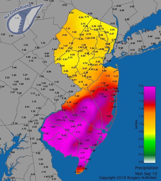
Figure 1. Rainfall from approximately 7AM on the 9th to 7AM on the 10th. Observations are from CoCoRaHS stations.
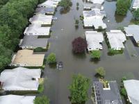
Flash flooding occurred at times in several locations, including on the 7th in the southwest along roadways such as the NJ Turnpike, I 295, and routes 55 and 130. Meanwhile, along the coast, this period saw persistent easterly (on shore) winds that on the 9th gusted to 43 mph in Harvey Cedars (Ocean), 41 mph in Seaside Heights (Ocean), and 40 mph at Sea Girt (Monmouth), and on the 10th reached 43 mph, 42 mph, and 41 mph, respectively, at these three locations. This piled up water along the coast, resulting in minor to moderate flooding, especially in Atlantic and Cape May counties.
A break in the rain ensued, but not for long, with scattered thunderstorms in the south during the afternoon of the 11th. Hefty totals included 3.43” in Franklin Township (Gloucester), Buena Vista (Atlantic) 3.06”, Pittsgrove (Salem) 2.61”, and Upper Deerfield (Cumberland) 2.32” (Figure 2). Next up were scattered showers during the afternoon and evening of the 12th, a very localized deluge in Somerset County during the predawn hours of the 13th, and then light rain during the daylight hours of the 13th (Figure 3). In Franklin Township (Somerset) rainfall totals included 5.12”, 0.91”, 0.73”, 0.66”, 0.64”, and 0.58”. Nearby Manville (Somerset) saw 3.32” and 2.83”, Readington (Hunterdon) 2.90”, and Bridgewater 2.60”. Flash flooding occurred along parts of I 287, Route 22, and on local roads.
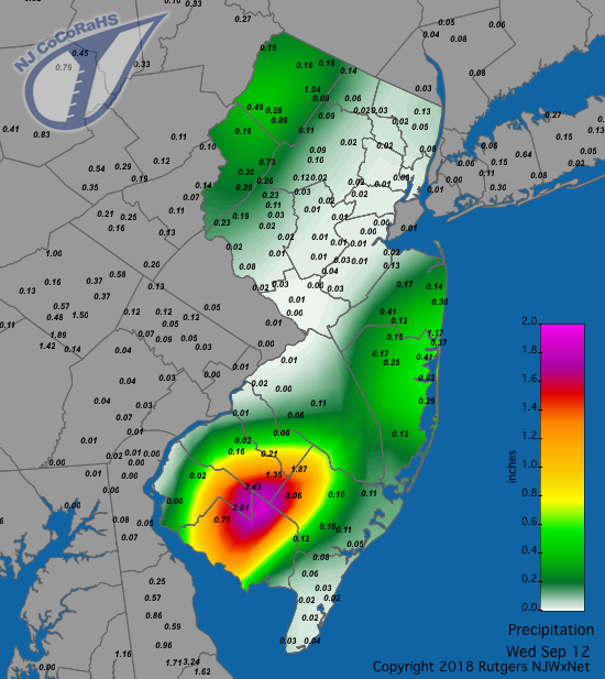
Figure 2. Rainfall from approximately 7AM on the 11th to 7AM on the 12th. Observations are from CoCoRaHS stations.
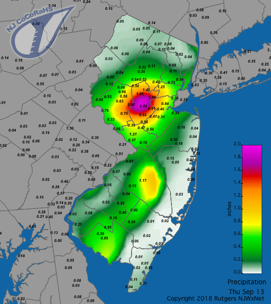
Figure 3. Rainfall from approximately 7AM on the 12th to 7AM on the 13th. Observations are from CoCoRaHS stations.
Heavy rainfall ceased until some scattered thunderstorms during the late afternoon and evening of the 17th in the western portion of northern NJ delivered 1.29” to Mine Hill (Morris), 1.26” at Holland Township (Hunterdon), 1.18” at Roxbury Township (Morris), and about 0.75”–1.00” in the general area. Morning showers on the 18th were followed by a north to south traveling squall line during the afternoon that included small hail in East Brunswick (Middlesex) and flash flooding in portions of Middlesex, Atlantic, and Cape May counties. Hefty totals included 3.12” in Galloway Township (Atlantic), South Brunswick (Middlesex) 2.33”, Port Republic (Atlantic) 2.15”, Hopewell Township (Mercer) 2.14”, North Wildwood (Cape May) 2.10”, and 2.01” at both South River and Plainsboro in Middlesex County.
The end of the month was rainy, beginning in the pre-dawn and into the afternoon of the 23rd in the southern half of the state. Rain was heaviest the farther south you went, totaling 2.94” in Dennis Township, three locations in Middle Township (Cape May) collecting 2.53”, 2.26”, and 1.66”, 2.47” and 2.38” falling in Woodbine, and 2.22” at Ocean City (Cape May; Figure 4).
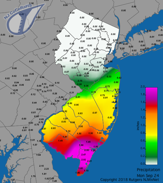
Figure 4. Rainfall from approximately 7AM on the 23rd to 7AM on the 24th. Observations are from CoCoRaHS stations.
Next up were a few showers in the south during the second half of the 24th that shifted northward as a warm front, bringing heavy rain to the northeast during the mid-day hours of the 25th and later in the afternoon to western Burlington and Mercer counties (Figure 5). The distribution of the heavier rainfall was quite the opposite of two days earlier (Figure 4). Prodigious totals in Bergen County included 6.13” in Palisades Park, Tenafly 4.72”, Bergenfield 4.40”, River Edge 3.87”, and River Vale 3.53”. Out of over 200 CoCoRaHS reports, two stations in Little Falls (Passaic) saw 3.36” and 3.30”, five others caught just over 3.00”, and 56 locations had between 2.00”–2.99”. Many roads experienced flash flooding in Essex, Hudson, Bergen, Mercer, and Burlington counties, with numerous water rescues from roads and buildings.
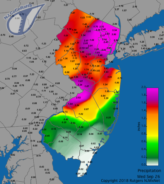
Figure 5. Rainfall from approximately 7AM on the 25th to 7AM on the 26th. Observations are from CoCoRaHS stations.
A mid-evening line of thunderstorms moved through all but the southeastern portion of the state on the 26th, quickly dropping 1.02” in Mansfield (Warren), 0.99” at White Township (Warren), and 0.95” in Andover. The 27th brought evening rain that picked up in intensity during the early portion of the 28th before tapering off during the morning. West central Jersey took top honors with 2.23” in Plainsboro, 2.21”, 2.17”, 2.11”, and 2.07” at four stations in Flemington (Hunterdon), Somerville (Somerset) 2.14”, with (out of 215 reports) ten stations between 2.00”–2.23”, 45 from 1.50”–1.99”, and 104 from 1.00”–1.99”.
Despite all of the rain, September barometric pressure was generally on the high side. The lowest pressure was observed on the 18th, ranging between 29.70”–29.75”. The highest value was on the 24th, from 30.40”–30.50”, almost matched on the 20th. Aside from the 40 mph wind gusts on three days mentioned earlier in this report, a month-high 44 mph gust was observed at High Point Monument on the 22nd.
Temperature
There were 13 afternoons in September where the maximum temperature equaled or exceeded 85° at one or more of the 63 NJWxNet stations. The 2nd to the 6th saw highs of at least 90°. The 2nd found Upper Deerfield up to 90°, and Pennsauken (Camden) and Sewell (Gloucester) at 89°. Hawthorne (Passaic) and Mansfield (Burlington) reached 95° on the 3rd, with 41 stations from 90°–94°. Yet hotter was the 4th, with Mansfield at 97°, Oswego Lake (Burlington), Cherry Hill (Camden), and Lower Alloways Creek Township (Salem) all at 96°, and 44 stations from 90°–95°. HPM was coolest at 82°. Sewell and Lower Alloways Creek made it to 96° on the 5th, with 39 stations between 90°–95°, while Seaside Heights and Harvey Cedars were just 82°. The 6th was the month’s hottest day, with Hamilton (Mercer) and Hawthorne roasting at 97°, seven stations at 96°, and 45 sites from 90°–95°. Harvey Cedars was least warm at 83°. Cape May Court House (Cape May) got to 88° on the 7th, as cooler air began infiltrating NJ, as witnessed at HPM where the temperature only rose to 68°.
It wasn’t long before above-normal temperatures returned, with Dennis Township and Lower Alloways Creek up to 86°. Another run of hot weather commenced on the 15th, with Haworth (Bergen) at 85°. Hawthorne hit 88° on the 16th and Vineland (Cumberland) 85° on the 17th. Highs of 89° were reached on the 18th at Oswego Lake, Point Pleasant (Ocean), and Vineland. The 19th saw the temperature rise to 86° at Vineland, Mansfield (Burlington), and Sewell. A week later on the 26th, 87° was achieved at Sewell and Howell (Monmouth).
With all the cloud cover and humidity, as mentioned above, minimum temperatures were quite elevated throughout September. Still, enough cool air was found to lower daily minimums into the 40°s on ten days, all but three of them from the 23rd onward. A cool spell from the 8th to 10th began with 49° reached at HPM and Wantage (Sussex) on the 8th. The 9th was a chilly day at HPM, with a low of 47° and maximum of only 51°. High Point (Sussex) had a low of 48° and Wantage 49°. HPM was 46° on the 10th, with six stations between 47°–49°. HPM fell to 46° on the 24th and 25th, 48° on the 27th, and 46° on the 28th. The 28th also found Berkeley Township (Ocean) at 47° and Basking Ridge (Somerset) at 48°. Berkeley Township and Pequest (Warren) reached 46° on the 29th, with 14 stations were from 47°–49°. The last day of September saw the coolest minimums of the early fall, with Basking Ridge bottoming out at 43°, four stations at 45°, and 12 between 46°–49°. The highest minimum on both the 29th and 30th was 61° at the Atlantic City Marina NJWxNet station (Atlantic).


