September Overview
September 2013 was the second consecutive month with the statewide average temperature coming in below normal. The 64.4° average was 1.8° below the 1981-2010 average. This ranks as the 40th coolest September since 1895, tied with 1920 and 1922, and the coolest since 1994.
Statewide precipitation averaged 2.40" in September. This is 1.67" below average and ranks as the 30th driest on record, tied with 1910. This is the first month since this past May with below-average precipitation.
Temperature
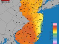
Of the first 21 days of the month, 14 saw at least one station within the 53 station NJ Weather and Climate Network reach 80°. Of these, seven saw a station reach at least 85°. Red Lion (Burlington County) and Cherry Hill (Camden) got to 91° on the 1st. The 2nd saw Dennis Township (Cape May) at 88° and West Cape May (Cape May) reaching 86°. Four stations topped out at 85° on the 3rd. Egg Harbor (Atlantic) and Dennis Township reached 86° on the 8th. Berkeley Township (Ocean) hit 89° on the 10th, when eight other stations reached 88°. The 11th was the warmest day statewide since July 20th. Howell (Monmouth) soared to 97° and Hawthorne (Passaic) hit 96°. Some 42 NJWxNet stations reached at least 90°, with Harvey Cedars (Ocean) the "coolest" at 80°. The last 85° or higher day of the month was the 12th, when Berkeley Township and Greenwich (Cumberland) both reached 92°.
Morning lows were in the 30°s with afternoon maximums of 80° or warmer at one or more locations elsewhere on the 7th and 19th. All told, there were 13 September days with lows in the 30°s somewhere in the state, with seven of these 35° or colder. The 9th saw Walpack (Sussex) fall to 35°. This valley station dropped to 33° on the 17th, when High Point Monument reached 36°. Walpack and Pequest (Warren) reached 33° on the 18th, with patchy frost at some of the 23 NJWxNet stations that fell into the 30°s. Kingwood (Hunterdon) was 35° on the 19th and Walpack 35° on the 23rd. Walpack recorded the first (and only) freeze of September, falling to 31° on the 24th, when 13 stations fell into the 30°s. While it is not all that unusual to see a September freeze at Walpack, at other northwest valley locations, or in the Pine Barrens, in many a year the first NJ freeze of the season at these locations is in early October. In 2011 it wasn't until October 27th that NJ's first freeze (at the High Point Monument NJWxNet station) was achieved as cold air rushed in ahead of the snowstorm that arrived two days later. The last sub-35° day of the month was the 25th when Walpack reached 33° and Pequest 35°.
Precipitation and storms
As expected, local differences accompanied the statewide 2.40" precipitation average for the month. Several locations were hit with heavy rain on multiple occasions, while passing showers and thunderstorms most often missed others. On the high end, Stratford Township (Camden) received 6.29" in September. This was followed by Somerdale (Camden) 6.01", Glen Rock (Bergen) 5.87", Glassboro (Gloucester) 5.62", Hawthorne (Passaic) 5.44", and Franklin Township (Hunterdon) 4.64". These totals demark where the localized heavy rains fell. Coming up short in the rainfall department was Atlantic City Marina (Atlantic) with 0.53". This was followed by Toms River (Ocean) 0.69", Middle Township (Cape May) 0.90", Brick Township (Ocean) 1.01" and 1.07", Point Pleasant Beach (Ocean) 1.02", and Berkeley Township (Ocean) with two stations at 1.06". Pockets with only 25%-50% of average monthly precipitation were found along the coast, in the far northwest, and in the urban northeast (excluding the Paterson area).
During the course of the month there were only four episodes with an inch or more of rain falling somewhere in NJ. The first two were not much more than a day apart. Thunderstorms during the morning hours of the 1st deposited as much as 2.12" in Riegelsville (Warren), 1.88" in Hightstown (Mercer), 1.62" in Jackson Township (Ocean), and 1.53" and 1.59" at two Oakland (Bergen) stations. At many locations around NJ totals were a few tenths of an inch to nothing. More widespread rain fell on the afternoon into the evening of the 2nd, with some excessive downpours leading to localized flash flooding. Glassboro (Gloucester) topped the list with 4.30", followed by 4.26" in Stratford (Camden), Elk Township (Gloucester) 4.12", Somerdale (Camden) 4.09", and Harvey Cedars (Ocean) 3.45". The heaviest rains were in Gloucester and western Atlantic counties and nearby parts of neighboring counties. Hunterdon and southern Warren saw heavy rains too, while most of the state saw several tenths of an inch, though drier along the northern coast and far southern Cape May County. Some local power failures accompanied the storms.
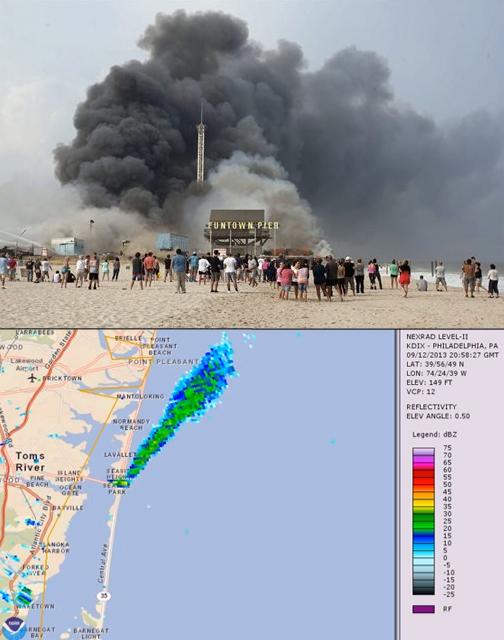
The 12th was a day of transition, as a cold front approached NJ from the west, destined to break the back of the brief hot spell and usher in a much cooler second half of the month. Ahead of the front were very warm temperatures and gusty southerly winds. The latter helped to fan the flames of the massive boardwalk fire in Seaside Park and Seaside Heights (Ocean County; more on this later). Elsewhere, late afternoon and late evening storms brought damaging winds and flooding to portions of north Jersey. A late afternoon storm deluged an area from southern Passaic County into northeastern Bergen County. Trees and branches fell, bringing down power lines, and flash flooding was prevalent. Similar conditions prevailed in the Warren-Morris county region later in the evening. Rainfall totaled 3.71" and 2.53" at two Hawthorne (Passaic) locations, 2.69" in Haworth (Bergen), 2.67" in Glen Rock (Bergen), 1.97" at River Vale (Bergen), and 1.63" at both Washington Township (Morris) and Oxford Township (Warren). The remainder of NJ had several tenths of an inch of rain, except the southwest, which came in under 0.20".
The final rain event of the month occurred from the evening of the 21st into the early hours of the 22nd. Most areas of the state saw over a half inch, except only a few tenths fell in the far northwest and along the coast. The heaviest totals occurred in the southwest, with inch plus totals northward into central NJ and the north central Highlands. Washington Township (Gloucester) received 2.01", Stratford (Camden) 1.95", Millstone Township (Monmouth) 1.88", Mt. Laurel Township (Burlington) 1.85", and Hainesport (Burlington) 1.83".
A fast-moving firestorm of sorts enveloped buildings housing at least 50 businesses along a four-block section of boardwalk in Seaside Park and Seaside Heights during the afternoon and evening of September 12th. The heroic actions of hundreds of firefighters and many others kept the inferno from spreading further north up the boardwalk. Fortunately only minor injuries occurred. There is no question that strong winds blowing from the south with gusts up to 30 mph measured at the nearby Seaside Heights NJWxNet station contributed to the rapid spread of the fire. A mid-evening slackening of the winds and a late evening shift in direction to a more westerly component assisted in bringing the fire under control. See the Office of the NJ State Climatologist's website post for a more complete discussion, including several graphs.
Only two September days saw winds gusting to 40 mph or higher at NJWxNet stations. A 52 mph gust was felt at Sicklerville (Camden) during a storm on the 2nd. The next highest gust that day was 30 mph in Hillsborough (Somerset). Storms on the 12th saw gusts to 47 mph at Pequest (Warren), 44 mph at Charlotteburg (Passaic), and into the 30-39 mph range at nine locations. Maximum atmospheric pressures were observed on the 17th, when they peaked at approximately 30.35". Minima near 29.70" occurred on the 13th.
Year-to-date Overview
The first nine months of 2013 have averaged very close to normal for temperature and have been wetter than average. The 55.9° statewide mean is exactly the January-September 1981-2010 average. However, given how mild recent decades have been compared to earlier ones dating back to 1895, this 2013 interval was the 23rd warmest of the past 119. Some 13 of the past 23 such intervals dating back to 1990 have been warmer than this year.
Precipitation has averaged 38.36" across NJ since January 1. This is 2.90" above the 1981-2010 mark and ranks as 27th wettest. Only five such intervals since 1990 have had greater totals.


