November Overview
In what has been a monthly see-saw of an autumn in the precipitation department (more below), November totals were on the low side. The statewide average total of 1.83” was 1.78” below the 1981–2010 mean. This ranked as the 22nd driest November since 1895. The northern half of the state averaged 2.31”, which is 1.55” below normal and ranks 31st driest. The south was drier at 1.54”, which is 1.91” below normal and ties with 1991 as the 18th driest. Temperature-wise it was the coldest month compared to normal since last November and, along with March, only the second below average one since then. The statewide average temperature of 41.3° was 3.9° below normal and ranks as the 27th coldest (tied with 1920 and 1955) of the past 125 Novembers. The north average 38.9°, which is 4.2° below normal and ties with six other years as the 24th coolest. The south averaged 42.6°, which is 3.8° below normal and ties with 1954 and 1972 as 27th coolest. Of late, there have been warmer and drier months compared to the norm, such as this past September and colder and wetter months including this past March. However, the last time New Jersey experienced a noteworthy dry and cold month (of any month) was November 2012 when the statewide average temperature was 3.7° below average and the precipitation 2.31” below average.
Precipitation and Storms
Few CoCoRaHS or NJWxNet stations exceeded the statewide climatological average for November. The Highlands received the most, with two West Milford (Passaic County) stations coming in with 4.81” and 4.10”. Jefferson Township (Morris) saw 4.13”, Mount Arlington (Morris) 3.94”, and both Long Hill Township (Morris) and Montague (Sussex) caught 3.86”. The south central region was driest, led by Toms River (Ocean) with 0.97”, Fortescue (Cumberland) 1.04”, Hammonton (Atlantic) 1.04” and 1.20” (two sites), Manchester Township (Ocean) with 1.13”, Cream Ridge (Monmouth) and Piney Hollow (Gloucester) each at 1.04”, Monroe Township (Gloucester) 1.16”, Medford Lakes (Burlington) and Tabernacle (Burlington) both with 1.18”, Evesham (Burlington) 1.19”, and Winslow Township (Camden) 1.20”.
The November totals include precipitation that fell late on October 31st into the early hours of November 1st. As discussed in the October report, a powerful cold front blasted through the state at that time, marking a major pattern shift across the United States that persisted for most of November. It bears repeating the portion of the October report that covered the event. Rainfall, most of which fell before midnight on October 31st, amounted to 2.26” at Walpack (Sussex), Sandyston (Sussex) 2.00”, Mount Arlington 1.85”, Jefferson Township 1.69”, and Blairstown (Warren) 1.63”. However, 89 of the 222 CoCoRaHS reports for the 24 hours ending on the morning of November 1st were under 0.50”, due to the rather short duration of the quick-hitting squall.
Winds howled as the squall line passed and an EF1 tornado occurred in Morris County. The tornado tore a discontinuous 4.9-mile long 150-yard wide path from Harding Township into Chatham Township, Madison, and Florham Park, touching down at 12:23 AM with 100 mph winds. Damage included downed trees falling onto homes, cars, and powerlines. Fortunately, there were no injuries reported. This was New Jersey’s 9th confirmed tornado in 2019, placing this year in a tie with 1987 for the second most on record since 1950, yet still well below the 17 in 1989. Elsewhere, damaging winds brought down trees and damaged some buildings at an airport in Wall Township (Monmouth). Gusts late on the 31st included Woodbine’s (Cape May) 49 mph, Point Pleasant (Ocean) 47 mph, Oswego Lake (Burlington) 46 mph, and nine other stations from 40–44 mph. Shortly after midnight, peak gusts reached 62 mph at High Point Monument (Sussex), Fortescue (Cumberland) 57 mph, Charlotteburg (Passaic) 54 mph, Hillsborough-Duke (Somerset) 54 mph, Harvey Cedars (Ocean) 53 mph, Woodbine 53 mph, Hammonton 50 mph, Moorestown (Burlington) 50 mph, and 17 other stations from 40–49 mph.
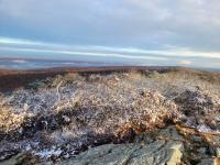
A dry first week of the month followed, until the 7th brought up to 0.50” of rain at Stillwater (Sussex). A few tenths of an inch fell elsewhere in the northwest and the first snowflakes of the season were reported at elevations over 1500’. Early on the 12th, a few tenths of an inch of rain fell in the southeast, with less elsewhere. Many locations saw their first snowflakes during that morning and early afternoon as temperatures declined on gusty winds. The ground was lightly covered in Hardyston (Sussex). The 12th began with dew points in the upper 40°s to low 50°s across all but the far northwest where the cold front arrived before midnight (Figure 1, left). By late evening much drier air covered the state, with dew points close to 0°, except still in the teens in the far south where they fell to near 0° early on the 13th (Figure 1, right).
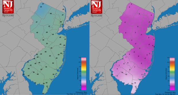
Figure 1. Maximum daily dew point temperatures at NJWxNet stations achieved during the early morning hours of November 12th (left). Late evening (10:54 PM) dew point temperatures approaching the daily minimum on 12th.
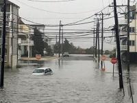
Minor coastal flooding occurred on the 17th–18th, the result of persistent onshore winds. The flow brought drizzle into the state during the daytime hours of the 18th, with moderate rain following during the evening into the early morning hours of the 19th. At 1.03”, West Milford received the most rain, with another station in the community catching 0.89”. Ringwood (Passaic) saw 0.92” and Vernon Township (Sussex) 0.91”.
Only a maximum 0.38” at Wildwood Crest (Cape May) could be wrung out of a weak system on the 22nd, with three Lower Township (Cape May) stations following with from 0.34”–0.37”. The only truly wet system of November arrived during the evening of the 23rd (Figure 2). At the outset of the event, sleet pellets mixed in with the rain at locations in north and central NJ. Rain became heavy overnight, ending in the early afternoon of the 24th. West Milford was again the wettest location in the state, with two reporting stations coming in with 2.03” and 1.66”. Vernon Township followed with 1.70”, Bloomingdale (Passaic) 1.66”, Kingwood (Hunterdon) 1.55”, Stockton (Hunterdon) 1.54”, and Lebanon (Hunterdon) 1.50”. Some 90 or the 227 reporting CoCoRaHS stations caught from 1.00”–1.49”. The least rain fell in Cape May County, with two Wildwood Crest stations at 0.31” and 0.43”, and four Lower Township sites from 0.41”–0.48”.
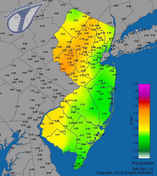
Figure 2. Rainfall from approximately 7AM on November 23rd to 7AM on November 24th. Observations are comprised of reports from CoCoRaHS stations.
The highest barometric pressure readings of the month were observed on the 14th and 16th, ranging from 30.40”–30.50”. The storm on the 24th contributed the lowest readings, in the 29.20” (east NJ) to 29.35” (west NJ) range. Aside from the strong winds early on the 1st, there were four other days with gusts exceeding 40 mph at one or more NJWxNet station. On the 16th, Harvey Cedars peaked at 41 mph, with Woodbine and Sea Girt (Monmouth) each up to 40 mph. Fortescue hit 45 mph on the 24th. A strong pressure gradient occurred in the Northeast on the 27th into Thanksgiving on the 28th resulting in a prolonged period of strong winds across NJ. Late evening 27th readings reached 52 mph at Pennsauken (Camden), 50 mph in Stewartsville (Warren), and 40–44 mph at five other locations. The 28th found gusts up to 49 mph at Mullica (Atlantic), Sea Girt and Pennsauken, and from 40–48 mph at 19 other NJWxNet stations. There were scattered reports of trees and branches down and some power outages from these winds.
Temperature
Despite being a colder-than-average month, there were ten days when one or more locations in the state reached at least 60°. The early hours of the 1st were the warmest of the month. Of the 64 NJWxNet stations, Hillsborough-Duke peaked at 74°, followed by 12 stations at 73°, and 27 from 70°–72°. The 4th found West Deptford (Gloucester) at 62° and 12 locations from 60°–61°. Five stations reached 65° on the 5th, with an impressive 49 other sites from 60°–64°. Lower Alloways Creek Township (Salem) got to 61° on the 6th and seven stations reached that mark on the 7th. Lower Alloways Creek was 60° on the 10th. Nine locations peaked at 68° on the 11th, with 47 from 60°–67°. In the southeast, Atlantic City Marina (Atlantic), Cape May Court House (Cape May), and Woodbine reached 60° on the 12th. Toward month’s end, seven stations hit 65° on the 26th with 43 from 60°–64°. On the 27th New Brunswick (Middlesex) topped out at 61° and both East Brunswick (Middlesex) and Hamilton (Mercer) reached 60°.
Winter-like cold dropped the thermometer to 20° or lower at some locations on ten occasions. The first such day was the 8th when Walpack bottomed out at 17°, High Point Monument (Sussex) and High Point (Sussex) 18°, Sandyston 19°, and Kingwood 20°. Minimum daily values were reached late in the evening, when for the first time all season, every NJWxNet station and the National Weather Service station at Newark Airport (Essex) reached the freezing mark, thus ending the growing season throughout the state. The first freezing temperature of the season was observed at the Walpack on October 4th and on the following morning at several other stations. More stations joined in on October 19th, however, it wasn’t until November 4th that a majority of stations fell below freezing. The last twelve NJWxNet stations to hit freezing on the 8th mainly hug the Atlantic and Delaware Bay coasts, with a few joining in up along the lower Delaware River and one in the Meadowlands. They include Point Pleasant, Seaside Heights (Ocean), Harvey Cedars, Atlantic City Marina, West Cape May (Cape May), Bivalve (Cumberland), Fortescue, Lower Alloways Creek Township, Logan Township (Gloucester), Pennsauken, Lyndhurst (Bergen), and Sea Girt.
The shortest growing season in 2019 was observed at Walpack, lasting 157 days (April 30th to October 3rd). Basking Ridge (Somerset) and Pequest (Warren) were each a day longer. The longest growing seasons occurred at Harvey Cedars and Atlantic City Marina, each lasting 220 days (April 2nd to November 7th). The 63-day difference in the length of the season across NJ is actually on the short end, as past years have included 103 day (2016) and 135 day (2015) differences.
The morning of the 9th dawned as one of the coldest on record for so early in the season. Walpack bottomed out at 11°, Hopewell Township (Mercer) 13°, and 35 stations from 14°–20° (Figure 3). Atlantic City Marina and Harvey Cedars were “warmest” at 29°. New Brunswick’s 19° minimum was a record for the date and also for so early in the season.
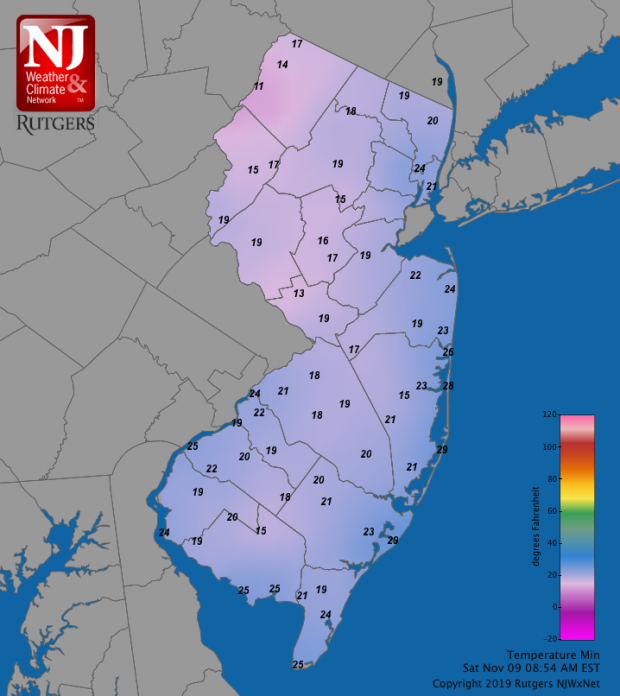
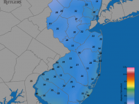
Figure 3. Minimum temperatures at NJWxNet stations on November 9th.
Cold continued on the 10th with Berkeley Township (Ocean) at 19° and Hopewell Township 20°. As cold air rushed back into the state on the 12th, High Point Monument reached 14°, High Point 15°, and five stations were from 18°–20°. High Point Monument and Walpack each fell to 11° on the 13th, and 24 locations were from 13°–20°. The 14th brought a minimum of 12° in Berkeley Township, 13° at Hopewell Township, and 15°–20° at 30 stations. Walpack was 16° on the 15th, with four stations from 18°–20°. Along with 18° at Walpack and 19° at the two High Point stations on the 16th came a return to low dew points (even lower than those on the 12th mentioned earlier). Lyndhurst’s dew point bottomed out at -9°, with Jersey City (Hudson), Pequest, and Sandyston all at -7°. The monthly minimum of 11° was reached for the third time on the 17th at Walpack, with the High Point stations at 16° and Sandyston 18°. Walpack dropped to 19° on the 23rd. The 30th found Walpack at 18° and High Point Monument 20°.
Fall 2019 Overview
Statewide, the fall (September–November) temperature averaged 56.1°. This is 0.9° above the 1981–2010 average and ranks as the 23rd warmest since 1895. Seasonal precipitation averaged 8.95”. At 2.60” below normal, fall ranked as the 44th driest on record.
Warm and dry were the key words to kick off the fall. The statewide average September temperature was the 9th warmest back to 1895, while precipitation ranked as the 7th driest. Mid to late October became wet, with the month ultimately ranking 15th wettest. Meanwhile, it remained warmer than normal, with the October temperature ranking 9th warmest. As reported above, the pattern flipped as November commenced, leading to a colder and drier-than-normal end to the season. No measurable snow fell during fall 2019 and there was the one tornado in Morris County early on November 1st.


