
Will the Present Strong El Niño Event Have a Major Impact on New Jersey’s Weather?
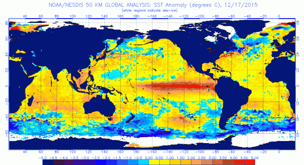
Roughly every two to seven years, a joint ocean – atmosphere phenomenon known as “El Niño” occurs. Right now happens to be one of those times and this event is showing every indication of being one of the three strongest El Niños of the past 65 years. An El Niño is defined as the prolonged warming of sea surface temperatures (SST) over the central and eastern equatorial Pacific and associated anomalies of atmospheric variables such as winds, clouds, and precipitation. According to the National Oceanic and Atmospheric Administration (NOAA), to be categorized as an El Niño, a 3-month SST anomaly of at least 0.9°F (0.5°C) above average must be observed in the central and eastern equatorial Pacific. There are related atmospheric anomalies elsewhere around the globe that are associated with conditions in the tropical Pacific. Do these anomalies extend to New Jersey, especially during a strong event? This article discusses the current El Niño episode as of mid-December and speculates as to whether NJ is already being impacted by this event and may continue to be into spring 2016.
 on Sunday, November 22nd. This was marveled at by many across NJ. Photo by Twitter user @CanoeCarnival.")
 on October 5. (Photo by Sharkey-Images).")
 on September 7. (Photo by B10 NJ Wildland Fire Page).")

 have been dropping steadily, leading to requests for voluntary water conservation (Photo by Tariq Zehawi/North Jersey Media Group)")
 on July 14. Photo by Layne Ball.")
 anomalies for July 20, 2015. NOAA/NESDIS.")

 during the afternoon of May 31st. Photo by Captain Jim Freda, Beach Manager for Borough of Sea Girt (@SGLifeguards).")