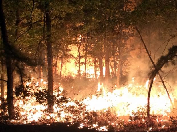
A Pinelands wildfire in Woodland Twp (Burlington County) on September 7. (Photo by B10 NJ Wildland Fire Page).
Overview
The ninth month of 2015 served as a bookend of sorts to an extended warm season. The average statewide temperature of 70.7° was 4.5° above the 1981–2010 normal and ranks as the 3rd warmest on record (since 1895). This ranking is the same as that achieved in May, with the intervening months all above average, though not nearly as much so as these shoulder months. Five of the ten warmest Septembers have occurred since 2002 (Table 1).
| Rank | Year | Sept. Avg. Temp. |
|---|---|---|
| 1 | 1961 | 71.4° |
| 2 | 2005 | 71.0° |
| 3 | 2015 | 70.7° |
| 4 | 1931 | 70.1° |
| 5 | 2010 | 69.5° |
| 6 | 2011 | 69.4° |
| 7 | 1998 | 68.9° |
| 8 | 1959 | 68.8° |
| 9 | 1945 | 68.7° |
| 10 | 2002 | 68.4° |
Table 1. Top 10 warmest NJ Septembers since 1895.
A look back at the past five months finds that this most recent May through September interval was the third warmest on record (Table 2). Even more notable than the recent run of warm Septembers, eight of the top ten warm seasons occurred within the last 18 years and four within the last six years.
| Rank | Year | May–Sept. Avg. Temp. |
|---|---|---|
| 1 | 2010 | 72.4° |
| 2 | 2011 | 71.8° |
| 3 | 2015 | 71.4° |
| 4 | 2012 | 71.1° |
| 5 | 2005 | 70.9° |
| 6 | 1959 | 70.5° |
| 7 | 1991 | 70.4° |
| 8 | 1999 | 70.3° |
| 9 | 2002 | 70.3° |
| 10 | 1998 | 70.3° |
Table 2. Top 10 warmest NJ May–September periods since 1895.
What had been a rather dry month with drought concerns ended on a damp note on the 30th with a wet episode that extended into early October. Through the 29th, the month ranked as the 14th driest. However, an approximate statewide-average rainfall of 1.50” on the 30th brought the monthly average to 3.44” (-0.63”) and with it the rank of 63rd driest. Some may wonder how this total can rank so close to the median value (it can also be looked at as the 59th wettest September) when it was over a half inch below average. There are two parts to an explanation of this. The first applies to monthly precipitation values in general and has to do with the skewness of totals over time. Precipitation totals are “bounded” by zero on one end of past values but there are no bounds on the high end. Thus totals such as those in September 1999 (9.58”, thanks to Hurricane Floyd) can far exceed the median and bring the long-term average quite a bit above the median. The second reason stems from the fact that Septembers were on average 0.27” wetter from 1981–2010 (the conventional 30-year average used in climate studies) than over the entire 1895–2015 observing history. Thus September 2015 was only 0.36” below the mean for the entire period of record.
The dry conditions from mid- to late summer led to the NJ Department of Environmental Protection issuing a drought watch on September 23rd for the three water supply regions (out of six statewide) in northeast, central, and north coastal areas. These have been the driest areas during the summer, leading to low stream flow, ground water, and reservoir levels. During a two-week rain-free period, surface moisture became exceedingly low and a 1000-acre fire burned in the Pinelands on the 7th–8th. Fortunately, despite another multi-week dry interval later in the month, no other significant fires burned elsewhere or during the remainder of the month. Recent precipitation has been extremely beneficial in replenishing surface moisture, getting streams and rivers flowing better in terms of both water quantity and quality, and of course minimizing fire danger. They are also reducing the need for late-season lawn and garden irrigation, rates of which had kept on a mid-summer like pace for most of September.
Temperature
Seven of the first nine days of the month saw temperatures top the 90° mark somewhere in NJ. South Harrison (Gloucester County) reached 94° on the 1st, with seven of the other 55 NJ Weather and Climate stations topping out at 93°. Hawthorne (Passaic) got to 95° and Cherry Hill (Camden) and Haworth (Bergen) 93° on the 2nd, while New Brunswick (Middlesex) and South Harrison hit 96° on the 3rd. Clayton (Gloucester) was 93° and South Harrison and Woodstown (Salem) 92° on the 4th. The last seasonal thrust of exceedingly hot weather impacted NJ on the 7th–9th, starting with Hawthorne and Haworth up to 95° and 94°, respectively, on the 7th. The month’s hottest day, and one that rivaled July 20th for the hottest of the summer, was the 8th. Hawthorne reached 98°, Haworth and New Brunswick 97°, and seven stations were either 95° or 96°. All told, 46 NJWxNet stations topped out at 90° or above. The mildest maximum on the 8th was Atlantic City Marina (Atlantic) at 82°. The last 90° day of the season occurred on the 9th, when Hamilton (Mercer) and Hillsborough (Somerset) reached 95°, with 37 other stations at 90°–94° and Seaside Heights (Ocean) “coolest” at 81°.
A recap of the 2015 90° season shows the highest counts in the driest areas (northeast urban and central Piedmont regions), which often have the most hot days in any summer. However, there is no question that the dry ground conditions in these areas amplified the maximum temperatures compared to wetter areas (or wetter summers). When moisture is available, a portion of the incoming solar energy goes to evapotranspiration, in the process transferring heat away from the ground and lower atmosphere as latent heat in water vapor. This heat is later released in the higher, cooler upper atmosphere as the vapor condenses to form clouds and rain. Of course with fewer clouds during dry periods more solar radiation makes it to the ground, further exacerbating the drying and heating.
New Brunswick reached the 90° or higher mark on 36 days between May 25th and September 9th. This was 15 days above average and tied for the 8th most annual days since 1896. The 35 days at Newark (Essex) were 8 above average. High Point Monument (Sussex) reached 87° on July 19th and 29th and September 8th but was never hotter. Annual 90° totals at these and other stations are listed in Table 3. The hottest temperature observed in New Jersey in 2015 was 98°. This occurred on July 19th at Newark, on August 17th at New Brunswick, and on September 8th at Hawthorne. On another note concerning the magnitude of summer warmth in New Brunswick, as of the end of September, the daily maximum at this central NJ location had equaled or exceeded 80° on 119 days in 2015. This exceeds the previous record maximum total of 115 days in 2010. Also, the consecutive string of 82° or higher daily maximums ended on September 9th at 66 days. This far exceeded the previous such string of 42 days, also in 2010.
| Station | County | Days ≥ 90° |
|---|---|---|
| New Brunswick | Middlesex | 36 |
| Hamilton | Mercer | 36 |
| Newark | Essex | 35 |
| Hillsborough | Somerset | 33 |
| Hawthorne | Passaic | 26 |
| Sicklerville | Camden | 26 |
| Haworth | Bergen | 24 |
| Woodbine | Cape May | 20 |
| Upper Deerfield | Cumberland | 15 |
| Sea Girt | Monmouth | 9 |
| West Cape May | Cape May | 5 |
| Wantage | Sussex | 2 |
| Harvey Cedars | Ocean | 2 |
| High Point Monument | Sussex | 0 |
Table 3. Number of days in 2015 with a maximum temperature of 90° or higher at selected New Jersey locations.
With dry conditions and lengthening nighttime hours, there were 14 days during the month when temperatures fell below 50° at one or more locations in the state. Nine of these days had lows between 38° and 45°. The first of these was on the 15th, when Pequest (Warren) reached 43° and Walpack (Sussex) and Oswego Lake (Burlington) were 44°. Eight of the month’s final eleven days saw minimums fall to 45° or lower, with Walpack one of these locations on each occasion. This northwest valley site fell to 43° on the 20th and 40° on the 21st, when Basking Ridge (Somerset) and Pequest were 45°. Walpack was 45° on the 22nd and Walpack and Pequest each 42° on the 23rd. The 24th was the coolest September morning, with Walpack at 38°, Basking Ridge 39°, Pequest and Berkeley Township (Ocean) 41°, and 20 other NJWxNet stations between 41°–49°. Walpack fell to 45° on the 25th and 26th, with Basking Ridge at 42° and Walpack and Pequest 43° on the 27th.
Precipitation and storms
Given the scattered nature of summer-like showers, September rainfall totals varied widely. As was rather commonly seen earlier in the summer, portions of northwestern and southwestern NJ were the wettest. Thanks to a very wet 30th, West Milford (Passaic) received the most with 7.38”. This was followed by Upper Deerfield (Cumberland) with 6.67”, East Greenwich (Gloucester) 6.48”, Blairstown (Warren) 6.20”, Andover (Sussex) 6.12”, and Jefferson Township (Morris) 6.05”. On the short end were northern coastal locations. Showers seemed to want to dodge Pine Beach (Ocean) where only 1.64” fell, followed by Berkeley Township 1.68”, Eatontown (Monmouth) 1.72”, Stafford Township (Ocean) 1.94”, and Point Pleasant Beach (Ocean) 2.04”.
There were just four September events that deposited an inch or more in some portion of the state and only two of them had widespread coverage. The first of the four was on the 4th when an isolated thunderstorm brought 1.16” to one CoCoRaHS station in Upper Deerfield while another in the community had only 0.23”. Woodstown received 0.40”. The remainder of the state was dry. The 9th–11th saw a statewide soaking that brought especially abundant totals to the northwest and southwest. The event started with scattered thunderstorms on the afternoon of the 9th. The most intense cell brought 2.38” and flash flooding to Holmdel (Monmouth). Overnight rain continued off and on through the 10th into the early hours of the 11th. Event totals included 4.05” in East Greenwich, Washington Township (Gloucester) 3.59”, Blairstown 3.44”, and Oxford (Warren) 3.14”. All told, 30 of the 224 reporting CoCoRaHS stations caught between 2.00”–2.99” and 1.63 from 1.00”–1.99”. On the short side, Stafford Township and Estell Manor (Atlantic) received just 0.19”.
The northwest saw rain from the evening of the 12th through the morning of the 13th. Liberty Township (Warren) caught 1.39”, Blairstown and Washington (Warren) 1.30”, and Rockaway Township (Morris) 1.24”. Little fell in central and southern areas, except up to 0.50” in the far south. This event was followed by rain-free conditions until the afternoon of the 29th. Despite the absence of precipitation, there was some extensive fog on the 19th and 29th, and scattered fog on several other mornings.
Scattered afternoon and evening showers on the 29th became a widespread heavy rain during the late evening into early morning of the 30th (Figure 1). A few tenths fell after morning CoCoRaHS observations on the 30th and are included in totals here but are not part of the statewide average mentioned previously. Topping the list was West Milford with 3.68”, followed by Rockaway Township 3.26”, Ringwood (Passaic) 3.23”, 3.19” and 3.08” at two Boonton (Morris) stations, and 3.00” in both Jackson Township (Ocean) and Bloomingdale (Passaic). Of the 226 CoCoRaHS reports, 53 stations received 2.00”–2.99”, and 152 from 1.00”–1.99”. Only four stations saw less than an inch, with Red Bank (Monmouth) lowest at 0.93”, followed by Fair Haven (Monmouth) with 0.96”.
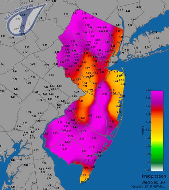
Figure 1. Rainfall between approximately 7AM September 29 and 7AM September 30.
Only one September day had a wind gust exceeding 40 mph somewhere in NJ. On the 14th, Wantage (Sussex) gusted to 43 mph and High Point Monument 41 mph. Kingwood (Hunterdon) had the next highest gust at 31 mph. Overall, the windiest day of the month was the 26th, with Woodbine (Cape May) gusting to 36 mph and eight other stations between 30–35 mph. The maximum barometric pressure during the month was in the 30.45”–30.50” range on the 26th. The lowest was from 29.60”–29.65” on the 12th.


