flash flooding

Sultry: July 2023 Recap
August 7, 2023 - 5:22pm -- Dave Robinson

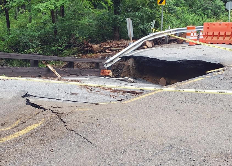
The aftermath of flash flooding in Warren County on July 16th as seen along Brass Castle Creek on Harmony Brass Castle Road by Hartsman Corner Road, Washington Township.

Yet another warmer-than-normal July is in the books. Nine of New Jersey’s 11 hottest Julys dating back to 1895 have occurred since 2010. Unlike last year where the heat was accompanied by the 12th driest July, this year was a wet and humid one, the 22nd wettest on record. The statewide average temperature of 77.2° was 1.8° above the 1991–2020 normal and 3.3° above the 1895–2021 period-of-record mean, ranking 10th warmest on record (tied with 2016). The average high was 87.0°, 1.3° above normal and ranking 18th warmest. The average low was 67.4°, 2.3° above normal and ranking 4th warmest. The northern climate division averaged 75.2° (+1.5°, 12th warmest), the southern division 78.5° (+2.0°, 10th), and the coast 78.3° (+2.1, 8th).

The 6.27” statewide average precipitation was 1.56” above normal to earn the 22nd wettest ranking. The northern division averaged 7.37” (+2.65”, 16th wettest), southern division 5.64” (+0.90”, 30th), and the coast 5.09” (+0.71”, 36th). The largest totals were found in Warren County and adjacent northwest counties, with some totals over a foot. The Pinelands region received the least, with totals of 2.50” to 3.50”.

Unprecedented: September 2021 Recap

October 11, 2021 - 4:38pm -- Dave Robinson

A flooded TD Bank Ballpark in Bridgewater (Somerset County) on September 2nd following the staggering rainfall caused by the remnants of Ida. Photo by Thomas P. Costello and Tariq Zehawi/USA Today Network.

Post-tropical storm Ida. The title of this month’s report speaks to this momentous weather extreme that will forever be the defining event of this month and likely the entire year. The storm delivered the most powerful tornado to strike the Garden State since 1990, demolishing multiple homes in Gloucester County. Rainfall exceeding 3.00” per hour led to the most widespread flash flood event on record for the state, resulting in the tragic deaths of 30 individuals in central and northeastern locales. A separate report on Ida has been prepared and may be accessed in the "News" menu.

There were 29 other days of weather this month that fortunately were not as dramatic as Ida on the 1st. All told, monthly precipitation averaged 6.20” across NJ. This was 2.04” above the 1991–2020 normal and ranks as the 15th wettest September since 1895. The north, where the bulk of Ida’s rain fell, averaged 8.92”, which was 4.46” above normal and ranks 7th wettest. The south averaged 4.61”, which was 0.62” above normal and ties as the 31st wettest. Along the coast, only 3.81” fell, some 0.08” below normal and ranking 44th wettest.

Ida Remnants Strike New Jersey

October 6, 2021 - 2:59pm -- Dave Robinson

Photo of flood debris from business establishments on Main Street in Manville on September 7 (photo credit: M. Holzer).

Post tropical storm Ida moved across the Garden State during the afternoon of September 1st into the early hours of the 2nd. It brought with it torrential rainfall, leading to flash and river flooding that took the lives of approximately 30 individuals and the rescue of countless more from raging waters. Additionally, it brought three tornadoes to southwestern and central areas, including the first EF-3 twister to strike New Jersey in 31 years. There were only minor injuries and no deaths from the tornadoes.

Ida developed in the Caribbean, being named a tropical storm on August 26th. From there, it moved northwestward, attaining hurricane status on the 27th as it passed over extreme western Cuba and moved into the Gulf of Mexico. It maintained a steady course as it strengthened into a major category 4 hurricane, making landfall in Louisiana on the 29th with sustained one-minute wind speeds as high as 150 mph. Once inland, winds diminished rather quickly but rainfall associated with the tempest remained heavy as the storm began to curve toward the northeast. This track remained quite steady as the storm weakened to a tropical depression on the 30th and became an extratropical low-pressure system as it approached the central Appalachians. On September 1st, Ida’s remnants merged with an advancing cold front as the system entered the Mid-Atlantic and crossed New Jersey before moving into southeast New England on the 2nd.

Subscribe to RSS - flash flooding